Webster, New Hampshire

Last updated

Webster, New Hampshire
WebsterNH OldMeetingHouse.jpg
Merrimack County New Hampshire incorporated and unincorporated areas Webster highlighted.svg
Location in Merrimack County and the state of New Hampshire.
Coordinates: 43°19′44″N71°43′04″W / 43.32889°N 71.71778°W / 43.32889; -71.71778
Country United States
State New Hampshire
County Merrimack
Incorporated 1860
VillagesWebster
Swetts Mills
Government
   Select Board David Hemenway, Chair
Normandie Blake
Marlo Herrick
  Town AdministratorDana Hadley
Area
[1]
  Total28.8 sq mi (74.6 km2)
  Land28.2 sq mi (73.1 km2)
  Water0.6 sq mi (1.5 km2)  2.02%
Elevation
682 ft (208 m)
Population
 (2020) [2]
  Total1,913
  Density68/sq mi (26.2/km2)
Time zone UTC-5 (Eastern)
  Summer (DST) UTC-4 (Eastern)
ZIP code
03303
Area code 603
FIPS code 33-80020
GNIS feature ID0873750
Website www.webster-nh.gov

Webster is a town in Merrimack County, New Hampshire, United States. The population was 1,913 at the 2020 census. [2]

Contents

History

A part of Boscawen until 1860, the town takes its name from American statesman Daniel Webster. [3]

Geography

According to the United States Census Bureau, the town has a total area of 28.8 square miles (74.6 km2), of which 28.2 square miles (73.1 km2) are land and 0.58 square miles (1.5 km2) are water, comprising 2.02% of the town. [1] The Blackwater River flows from north to south through the town, leading to the Contoocook River in Hopkinton. The entire town is part of the Merrimack River watershed. The highest point in Webster is 870 feet (270 m) above sea level, on an unnamed summit near the center of town that overlooks the eastern shore of Lake Winnepocket.

Adjacent municipalities

Demographics

Historical population
CensusPop.Note
1870 689
1880 647−6.1%
1890 564−12.8%
1900 496−12.1%
1910 445−10.3%
1920 334−24.9%
1930 3607.8%
1940 351−2.5%
1950 38610.0%
1960 45718.4%
1970 68048.8%
1980 1,09561.0%
1990 1,40528.3%
2000 1,57912.4%
2010 1,87218.6%
2020 1,9132.2%
U.S. Decennial Census [2] [4]

At the 2000 census there were 1,579 people, 581 households, and 464 families living in the town. The population density was 56.6 inhabitants per square mile (21.9/km2). There were 672 housing units at an average density of 24.1 per square mile (9.3/km2). The racial makeup of the town was 98.86% White, 0.06% African American, 0.06% Native American, 0.38% Asian, 0.06% from other races, and 0.57% from two or more races. Hispanic or Latino of any race were 0.13%. [5]

Of the 581 households 34.9% had children under the age of 18 living with them, 68.3% were married couples living together, 7.4% had a female householder with no husband present, and 20.1% were non-families. 14.5% of households were one person and 4.6% were one person aged 65 or older. The average household size was 2.71 and the average family size was 2.99.

The age distribution was 25.8% under the age of 18, 5.3% from 18 to 24, 31.7% from 25 to 44, 27.9% from 45 to 64, and 9.2% 65 or older. The median age was 39 years. For every 100 females, there were 94.0 males. For every 100 females age 18 and over, there were 93.2 males.

The median household income was $54,052 and the median family income was $57,396. Males had a median income of $35,449 versus $24,250 for females. The per capita income for the town was $20,852. About 3.6% of families and 5.0% of the population were below the poverty line, including 5.0% of those under age 18 and 5.4% of those age 65 or over.

Related Research Articles

<span class="mw-page-title-main">Merrimack County, New Hampshire</span> County in New Hampshire, United States

Merrimack County is a county in the U.S. state of New Hampshire. As of the 2020 Census, the population was 153,808, making it the third most populous county in New Hampshire. Its county seat is Concord, the state capital. The county was organized in 1823 from parts of Hillsborough and Rockingham counties, and is named for the Merrimack River. Merrimack County comprises the Concord, NH Micropolitan Statistical Area, which in turn constitutes a portion of the Boston–Worcester–Providence, MA–RI–NH–CT Combined Statistical Area. In 2010, the center of population of New Hampshire was located in Merrimack County, in the town of Pembroke.

<span class="mw-page-title-main">Bridgewater, New Hampshire</span> Town in New Hampshire, United States

Bridgewater is a town in Grafton County, New Hampshire, United States. The population was 1,160 at the 2020 census.

<span class="mw-page-title-main">East Merrimack, New Hampshire</span> Census-designated place in New Hampshire, United States

East Merrimack is a census-designated place (CDP) in the town of Merrimack, Hillsborough County, New Hampshire, United States. There is no village center named "East Merrimack"; rather, the CDP refers to the region of the town of Merrimack lying east of the F. E. Everett Turnpike, overlapping portions of the villages of Reeds Ferry, Thornton's Ferry, and the center of Merrimack. The population was 5,176 at the 2020 census, up from 4,197 at the 2010 census.

<span class="mw-page-title-main">Weare, New Hampshire</span> Town in New Hampshire, United States

Weare is a town in Hillsborough County, New Hampshire, United States. The population was 9,092 at the 2020 census. It is close to two important New Hampshire cities, Manchester and Concord.

<span class="mw-page-title-main">Boscawen, New Hampshire</span> Town in New Hampshire, United States

Boscawen is a town in Merrimack County, New Hampshire, United States. The population was 3,998 at the 2020 census.

<span class="mw-page-title-main">Bow, New Hampshire</span> Town in New Hampshire, United States

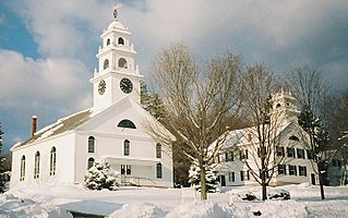
Bow is a town in Merrimack County, New Hampshire, United States. The population was 8,229 at the 2020 census, up from 7,519 at the 2010 census, an increase of 9.4%.

<span class="mw-page-title-main">Canterbury, New Hampshire</span> Town in New Hampshire, United States

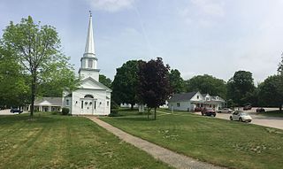
Canterbury is a town in Merrimack County, New Hampshire, United States. The population was 2,389 at the 2020 census. The Canterbury Shaker Village is in the eastern part of the town.

<span class="mw-page-title-main">Chichester, New Hampshire</span> Town in New Hampshire, United States

Chichester is a town in Merrimack County, New Hampshire, United States. The population was 2,665 at the 2020 census.

<span class="mw-page-title-main">Contoocook, New Hampshire</span> Census-designated place in New Hampshire, United States

Contoocook is a village and census-designated place (CDP) within the town of Hopkinton in Merrimack County, New Hampshire, United States. The population was 1,427 at the 2020 census. Contoocook is well known for its growth of small businesses, preservation of historical landmarks, community involvement and recreational activities within the village.

<span class="mw-page-title-main">Dunbarton, New Hampshire</span> Town in New Hampshire, United States

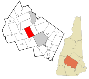
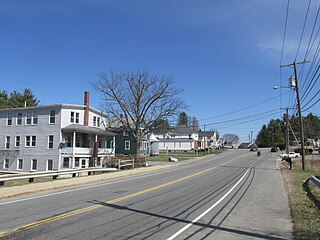
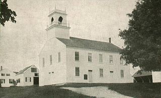
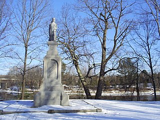
Dunbarton is a town in Merrimack County, New Hampshire, United States. The population was 3,005 at the 2020 census, up from 2,758 at the 2010 census.

<span class="mw-page-title-main">Franklin, New Hampshire</span> City in New Hampshire, United States

Franklin is a city in Merrimack County, New Hampshire, United States. At the 2020 census, the population was 8,741, the lowest figure of New Hampshire's 13 cities. Franklin includes the village of West Franklin.

<span class="mw-page-title-main">Hill, New Hampshire</span> Town in New Hampshire, United States

Hill is a town in Merrimack County, New Hampshire, United States. The population was 1,017 at the 2020 census. It is home to William Thomas State Forest.

<span class="mw-page-title-main">Hopkinton, New Hampshire</span> Town in New Hampshire, United States

Hopkinton is a town in Merrimack County, New Hampshire, United States. The population was 5,914 at the 2020 census. The town has three distinct communities: Hopkinton village, mainly a residential area in the center of the town; Contoocook, the town's business hub, located in the north; and West Hopkinton, within the more agricultural portion of the town. The town is home to the Hopkinton State Fair, adjacent to Contoocook village, and to the historic Contoocook Railroad Depot and the Contoocook Railroad Bridge, the oldest covered railroad bridge in the United States.

<span class="mw-page-title-main">Salisbury, New Hampshire</span> Town in New Hampshire, United States

Salisbury is a town in Merrimack County, New Hampshire, United States. The population was 1,422 at the 2020 census.

<span class="mw-page-title-main">Suncook, New Hampshire</span> Census-designated place in New Hampshire, United States

Suncook is a census-designated place (CDP) in Merrimack County, New Hampshire, United States. The population was 5,501 at the 2020 census. Approximately two-thirds of Suncook is located in the town of Pembroke, with the remainder in Allenstown.

<span class="mw-page-title-main">Warner, New Hampshire</span> Town in New Hampshire, United States

Warner is a town in Merrimack County, New Hampshire, United States. The population was 2,937 at the 2020 census. The town is home to Magdalen College of the Liberal Arts, Rollins State Park and Mount Kearsarge State Forest.

<span class="mw-page-title-main">Wilmot, New Hampshire</span> Town in New Hampshire, United States

Wilmot is a town in Merrimack County, New Hampshire, United States. The population was 1,407 at the 2020 census. The town includes the communities of Wilmot, Wilmot Flat, and North Wilmot.

<span class="mw-page-title-main">East Kingston, New Hampshire</span> Place in New Hampshire, United States

East Kingston is a town in Rockingham County, New Hampshire, United States. The population was 2,441 at the 2020 census.

<span class="mw-page-title-main">Wentworth, New Hampshire</span> Town in New Hampshire, United States

Wentworth is a town in Grafton County, New Hampshire, United States. The population was 845 at the 2020 census, down from 911 at the 2010 census. The town is home to Plummer's Ledge Natural Area, and part of the White Mountain National Forest is in the northeast. The town has a picturesque common, presided over by a Federal-style church and bordered by antique homes.

<span class="mw-page-title-main">Henniker, New Hampshire</span> Town in New Hampshire, United States

Henniker is a town in Merrimack County, New Hampshire, United States. As of the 2020 census, the reported total population of the town was 6,185, although the figure, 27.9% greater than the 2010 population, has been questioned by local officials. Henniker is home to New England College and Pats Peak Ski Area. Henniker is a college town and resort area, featuring both skiing and white-water kayaking.

References

  1. 1 2 "2021 U.S. Gazetteer Files – New Hampshire". United States Census Bureau. Retrieved December 16, 2021.
  2. 1 2 3 "Webster town, Merrimack County, New Hampshire: 2020 DEC Redistricting Data (PL 94-171)". U.S. Census Bureau. Retrieved December 16, 2021.
  3. History of Boscawen and Webster
  4. "Census of Population and Housing". Census.gov. Retrieved June 4, 2016.
  5. "U.S. Census website". United States Census Bureau . Retrieved January 31, 2008.