Campton, New Hampshire

Last updated

Campton, New Hampshire
Town
Campton NH 1.JPG
NH 175 in Campton Upper Village
Campton TownSeal.png
Grafton-Campton-NH.svg
Coordinates: 43°51′53″N71°38′12″W / 43.86472°N 71.63667°W / 43.86472; -71.63667
Country United States
State New Hampshire
County Grafton
Incorporated 1767
Villages
  • Beebe River
  • Campton Hollow
  • Campton Lower Village
  • Campton Upper Village
  • West Campton
Government
   Board of Selectmen
  • Craig Engel, Chair
  • Mort Donahue
  • Sharon Davis
  • Dan Boynton
  • Nik Coates
  Town AdministratorCorey Davenport
Area
[1]
  Total52.5 sq mi (136.1 km2)
  Land51.9 sq mi (134.3 km2)
  Water0.7 sq mi (1.8 km2)  1.33%
Elevation
676 ft (206 m)
Population
 (2020) [2]
  Total3,343
  Density64/sq mi (24.9/km2)
Time zone UTC-5 (Eastern)
  Summer (DST) UTC-4 (Eastern)
ZIP code
03223
Area code 603
FIPS code 33-08660
GNIS feature ID0873556
Website www.camptonnh.org

Campton is a town in Grafton County, New Hampshire, United States. The population was 3,343 at the 2020 census. [2] Campton, which includes the villages of Blair, Campton Hollow, Lower Campton and West Campton, is home to Blair State Forest and Livermore Falls State Forest. It is located in the foothills of the White Mountains, and parts of the White Mountain National Forest are in the northeast and northwest.

Contents

History

Both Campton and adjacent Rumney were granted by Governor Benning Wentworth in 1761 to Jabez Spencer of East Haddam, Connecticut, then settled about 1765. But Captain Spencer died before terms of the charter, which required settlement by 50 families, each farming 5 acres (20,000 m2) for every 50 received, were fulfilled. Two families, named Fox and Taylor, first settled here in 1765. [3] In 1767, Governor John Wentworth issued the heirs and others a new grant. Campton got its name when the first proprietors built a camp here to survey the two towns. [4]

Although the surface is mountainous and ledgy, farmers found good soil for cultivation in the intervales along the rivers. By 1859, when the population was 1,439, industries included one sawmill, one gristmill, one tannery and a carriage shop. [4] The town has three covered bridges, including Blair Bridge, which is 292 feet (89 m), 10 inches long, making it the second longest of those entirely within the state. [5]

Geography

The Pemigewasset River at Livermore Falls Livermore Falls.jpg
The Pemigewasset River at Livermore Falls

According to the United States Census Bureau, the town has a total area of 52.5 square miles (136.1 km2), of which 51.9 square miles (134.3 km2) are land and 0.69 square miles (1.8 km2) are water, comprising 1.33% of the town. [1] The highest point in Campton is Mount Weetamoo, at 2,548 feet (777 m) above sea level. The town is drained by the Pemigewasset River and its tributaries the Mad River, Beebe River, West Branch Brook, and Bog Brook. Campton lies fully within the Merrimack River watershed. [6]

The town is crossed by Interstate 93, U.S. Route 3, New Hampshire Route 49 and New Hampshire Route 175. Starting with the 2012 election, Campton was redistricted from NH's 2nd Congressional District to New Hampshire's 1st Congressional District; it was the only town in Grafton County to be redistricted.

Demographics

Historical population
CensusPop.Note
1790 395
1800 63560.8%
1810 87337.5%
1820 1,04719.9%
1830 1,31325.4%
1840 1,51315.2%
1850 1,439−4.9%
1860 1,320−8.3%
1870 1,226−7.1%
1880 1,163−5.1%
1890 982−15.6%
1900 9991.7%
1910 845−15.4%
1920 1,02821.7%
1930 1,18415.2%
1940 1,130−4.6%
1950 1,1491.7%
1960 1,058−7.9%
1970 1,17110.7%
1980 1,69444.7%
1990 2,37740.3%
2000 2,71914.4%
2010 3,33322.6%
2020 3,3430.3%
U.S. Decennial Census [2] [7]

As of the census [8] of 2000, there were 2,719 people, 1,128 households, and 759 families residing in the town. The population density was 52.4 inhabitants per square mile (20.2/km2). There were 1,759 housing units at an average density of 33.9 per square mile (13.1/km2). The racial makeup of the town was 98.01% White, 0.04% African American, 0.04% Native American, 0.70% Asian, 0.15% Pacific Islander, and 1.07% from two or more races. Hispanic or Latino of any race were 0.40% of the population.

There were 1,128 households, out of which 30.2% had children under the age of 18 living with them, 54.8% were married couples living together, 8.2% had a female householder with no husband present, and 32.7% were non-families. 25.0% of all households were made up of individuals, and 8.2% had someone living alone who was 65 years of age or older. The average household size was 2.41 and the average family size was 2.89.

In the town, the population was spread out, with 23.8% under the age of 18, 7.2% from 18 to 24, 30.0% from 25 to 44, 27.0% from 45 to 64, and 11.9% who were 65 years of age or older. The median age was 39 years. For every 100 females, there were 99.9 males. For every 100 females age 18 and over, there were 100.1 males.

The median income for a household in the town was $39,213, and the median income for a family was $46,492. Males had a median income of $30,640 versus $24,688 for females. The per capita income for the town was $20,189. About 5.8% of families and 8.8% of the population were below the poverty line, including 9.1% of those under age 18 and 8.5% of those age 65 or over.

Notable people

Sites of interest

See also

Related Research Articles

<span class="mw-page-title-main">Grafton County, New Hampshire</span> County in New Hampshire, United States

Grafton County is a county in the U.S. state of New Hampshire. As of the 2020 census, the population was 91,118. Its county seat is the town of Haverhill. In 1972, the county courthouse and other offices were moved from Woodsville, a larger village within the town of Haverhill, to North Haverhill.

<span class="mw-page-title-main">Stratford, New Hampshire</span> Town in New Hampshire, United States

Stratford is a town located on the Connecticut River in Coös County, New Hampshire, United States. The population was 662 at the 2020 census, a decline from the figure of 746 tabulated in 2010. Within the town are the villages of North Stratford, Stratford Hollow, and Beatties. U.S. Route 3 passes through the center of town, as does the St. Lawrence and Atlantic Railroad, formerly a part of the Grand Trunk Railway.

<span class="mw-page-title-main">Alexandria, New Hampshire</span> Town in New Hampshire, United States

Alexandria is a town in Grafton County, New Hampshire, United States. The population was 1,776 at the 2020 census, up from 1,613 at the 2010 census. Newfound Lake is in the northeast corner, with Wellington State Park on the western shore. The town is home to Welton Falls State Forest. Cardigan Mountain State Park, with Mount Cardigan, is in the west. Another attraction is Mowglis Mountain, named for Rudyard Kipling's Jungle Book hero.

<span class="mw-page-title-main">Bath, New Hampshire</span> Town in New Hampshire, United States

Bath is a town in Grafton County, New Hampshire, United States. The population was 1,077 at the 2020 census, unchanged from the 2010 census. Now a tourist destination and commuter town for Littleton, the town is noted for its historic architecture, including the Brick Store and three covered bridges. Bath includes the village of Swiftwater and part of the district known as Mountain Lakes.

<span class="mw-page-title-main">Benton, New Hampshire</span> Town in New Hampshire, United States

Benton is a town in Grafton County, New Hampshire, United States. The population was 374 at the 2020 census. Located in the White Mountains, Benton is largely surrounded by the White Mountain National Forest. The town is crossed by the Appalachian Trail.

<span class="mw-page-title-main">Bridgewater, New Hampshire</span> Town in New Hampshire, United States

Bridgewater is a town in Grafton County, New Hampshire, United States. The population was 1,160 at the 2020 census.

<span class="mw-page-title-main">Dorchester, New Hampshire</span> Town in New Hampshire, United States

Dorchester is a town in Grafton County, New Hampshire, United States. The population was 339 at the 2020 census.

<span class="mw-page-title-main">Easton, New Hampshire</span> Town in New Hampshire, United States

Easton is a town in Grafton County, New Hampshire, United States. The population was 292 at the 2020 census.

<span class="mw-page-title-main">Ellsworth, New Hampshire</span> Town in New Hampshire, United States

Ellsworth is a town in Grafton County, New Hampshire, United States. The population was 93 at the 2020 census.

<span class="mw-page-title-main">Holderness, New Hampshire</span> Town in New Hampshire, United States

Holderness is a town in Grafton County, New Hampshire, United States. The population was 2,004 at the 2020 census. An agricultural and resort area, Holderness is home to the Squam Lakes Natural Science Center and is located on Squam Lake. Holderness is also home to Holderness School, a co-educational college-preparatory boarding school.

<span class="mw-page-title-main">Landaff, New Hampshire</span> Town in New Hampshire, United States

Landaff is a town in Grafton County, New Hampshire, United States. As of the 2020 census, the town population was 446.

<span class="mw-page-title-main">Lyman, New Hampshire</span> Town in New Hampshire, United States

Lyman is a town in Grafton County, New Hampshire, United States. The population was 585 at the 2020 census.

<span class="mw-page-title-main">Monroe, New Hampshire</span> Town in New Hampshire, United States

Monroe is a town in Grafton County, New Hampshire, United States. The population was 864 at the 2020 census, up from 788 at the 2010 census. The town is located along the Connecticut River, across from Barnet, Vermont. It was originally chartered as part of Lyman.

<span class="mw-page-title-main">Orange, New Hampshire</span> Town in New Hampshire, United States

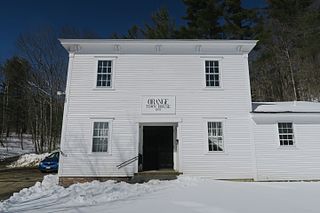
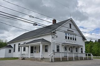
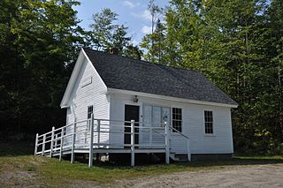
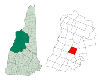
Orange is a town in Grafton County, New Hampshire, United States. The population was 277 at the 2020 census, down from 331 at the 2010 census.

<span class="mw-page-title-main">Rumney, New Hampshire</span> Town in New Hampshire, United States

Rumney is a town in Grafton County, New Hampshire, United States. The population was 1,498 at the 2020 census. The town is located at the southern edge of the White Mountain National Forest.

<span class="mw-page-title-main">Warren, New Hampshire</span> Town in New Hampshire, United States

Warren is a town in Grafton County, New Hampshire, United States. The population was 825 at the 2020 census, down from 904 at the 2010 census. Warren includes the village of Glencliff. The Appalachian Trail crosses the town in the west.

<span class="mw-page-title-main">Enfield, New Hampshire</span> Town in New Hampshire, United States

Enfield is a town in Grafton County, New Hampshire, United States. The population was 4,465 at the 2020 census. The town includes the villages of Enfield, Enfield Center, Upper Shaker Village, Lower Shaker Village, Lockehaven, and Montcalm.

<span class="mw-page-title-main">Plymouth (CDP), New Hampshire</span> Census-designated place in New Hampshire, United States

Plymouth is a census-designated place (CDP) and the main village in the town of Plymouth in Grafton County, New Hampshire, United States. Its population was 4,730 at the 2020 census, out of 6,682 in the entire town. The CDP includes the campus of Plymouth State University.

<span class="mw-page-title-main">Plymouth, New Hampshire</span> Town in New Hampshire, United States

Plymouth is a rural town in Grafton County, New Hampshire, United States, in the White Mountains Region. It has a unique role as the economic, medical, commercial, and cultural center for the predominantly rural Plymouth, NH Labor Market Area. Plymouth is located at the confluence of the Pemigewasset and Baker rivers and sits at the foot of the White Mountains. The town's population was 6,682 at the 2020 census. It is home to Plymouth State University, Speare Memorial Hospital, and Plymouth Regional High School.

<span class="mw-page-title-main">Seabrook Beach, New Hampshire</span> Census-designated place in New Hampshire, United States

Seabrook Beach is a census-designated place in the town of Seabrook and partially in the town of Hampton in Rockingham County, New Hampshire, United States. It had a population of 1,078 at the 2020 census.

References

  1. 1 2 "2021 U.S. Gazetteer Files – New Hampshire". United States Census Bureau. Retrieved November 19, 2021.
  2. 1 2 3 "Campton town, Grafton County, New Hampshire: 2020 DEC Redistricting Data (PL 94-171)". U.S. Census Bureau. Retrieved November 19, 2021.
  3. Article in Statistics and Gazetteer of New-Hampshire (1875)
  4. 1 2 Austin J. Coolidge & John B. Mansfield, A History and Description of New England; Boston, Massachusetts 1859
  5. New Hampshire Covered Bridges -- Blair Bridge
  6. Foster, Debra H.; Batorfalvy, Tatianna N.; Medalie, Laura (1995). Water Use in New Hampshire: An Activities Guide for Teachers. U.S. Department of the Interior and U.S. Geological Survey.
  7. "Census of Population and Housing". Census.gov. Retrieved June 4, 2016.
  8. "U.S. Census website". United States Census Bureau . Retrieved January 31, 2008.
  9. "LIVERMORE, Arthur, (1766 - 1853)". Biographical Directory of the United States Congress. Retrieved January 14, 2014.