Easton, New Hampshire

Last updated

Easton, New Hampshire
Town
Town center, Easton NH.jpg
Town center
Grafton-Easton-NH.png
Coordinates: 44°08′46″N71°47′24″W / 44.14611°N 71.79000°W / 44.14611; -71.79000
Country United States
State New Hampshire
County Grafton
Incorporated 1876
Government
   Board of Selectmen Zak Mei
Bob Thibault
Toni Woodruff
Area
[1]
  Total31.15 sq mi (80.68 km2)
  Land31.14 sq mi (80.64 km2)
  Water0.02 sq mi (0.04 km2)  0.04%
Elevation
1,167 ft (356 m)
Population
 (2020) [2]
  Total292
  Density9/sq mi (3.6/km2)
Time zone UTC-5 (Eastern)
  Summer (DST) UTC-4 (Eastern)
ZIP Codes
03580 (Franconia/Easton)
03785 (Woodsville)
Area code 603
FIPS code 33-22020
GNIS feature ID0873586
Website easton-nh.org

Easton is a town in Grafton County, New Hampshire, United States. The population was 292 at the 2020 census. [2]

Contents

History

Formed from a part of Landaff known as East Landaff, Easton was incorporated in 1876. Kinsman Mountain, the Kinsman Range, and Kinsman Notch are named for Nathaniel Kinsman, one of the original settlers. [3]

Geography

According to the United States Census Bureau, the town has a total area of 31.2 square miles (80.7 km2), of which 0.02 square miles (0.04 km2), or 0.04%, are water. [1] The west-flowing Wild Ammonoosuc River drains the southern part of town, while the north-flowing Ham Branch of the Gale River drains the northern portion and passes the town's village. Easton lies fully within the Connecticut River watershed. [4] The Kinsman Range of the White Mountains occupies the eastern side of the town, with the ridgecrest to the east in the town of Lincoln. The highest point in Easton is 4,040 feet (1,230 m) above sea level, just west of the 4,293-foot (1,309 m) summit of the North Peak of Kinsman Mountain.

New Hampshire Route 116 crosses the town from north to south, passing through the town center. New Hampshire Route 112 crosses the southern part of the town from east to west, following the Wild Ammonoosuc River.

Demographics

Historical population
CensusPop.Note
1880 302
1890 248−17.9%
1900 2490.4%
1910 226−9.2%
1920 131−42.0%
1930 1320.8%
1940 15618.2%
1950 94−39.7%
1960 74−21.3%
1970 9224.3%
1980 12434.8%
1990 22379.8%
2000 25614.8%
2010 254−0.8%
2020 29215.0%
U.S. Decennial Census [2] [5]

At the 2000 census there were 256 people, 117 households, and 84 families living in the town. The population density was 8.2 people per square mile (3.2/km2). There were 187 housing units at an average density of 6.0 per square mile (2.3/km2). The racial makeup of the town was 96.48% White, 0.78% Native American, and 2.73% from two or more races. Hispanic or Latino of any race were 0.78%. [6]

Of the 117 households 23.9% had children under the age of 18 living with them, 58.1% were married couples living together, 10.3% had a female householder with no husband present, and 28.2% were non-families. 23.1% of households were one person and 6.8% were one person aged 65 or older. The average household size was 2.19 and the average family size was 2.54.

The age distribution was 19.1% under the age of 18, 3.9% from 18 to 24, 22.3% from 25 to 44, 35.2% from 45 to 64, and 19.5% 65 or older. The median age was 47 years. For every 100 females, there were 98.4 males. For every 100 females age 18 and over, there were 97.1 males.

The median household income was $49,167 and the median family income was $69,375. Males had a median income of $41,875 versus $23,750 for females. The per capita income for the town was $31,841. About 6.0% of families and 10.0% of the population were below the poverty line, including 30.6% of those under the age of eighteen and none of those sixty five or over.

Notable person

Related Research Articles

<span class="mw-page-title-main">Grafton County, New Hampshire</span> County in New Hampshire, United States

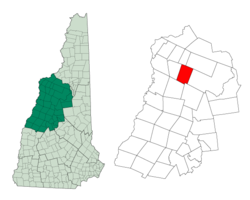
Grafton County is a county in the U.S. state of New Hampshire. As of the 2020 census, the population was 91,118. Its county seat is the town of Haverhill. In 1972, the county courthouse and other offices were moved from Woodsville, a larger village within the town of Haverhill, to North Haverhill.

<span class="mw-page-title-main">Dummer, New Hampshire</span> Town in New Hampshire, United States

Dummer is a town in Coös County, New Hampshire, United States. The population was 306 at the 2020 census. It is part of the Berlin, NH–VT micropolitan statistical area. Dummer is home to the Pontook Reservoir, popular with canoeists, kayakers and birdwatchers. In the western part of Dummer lies the village of Paris.

<span class="mw-page-title-main">Bath, New Hampshire</span> Town in New Hampshire, United States

Bath is a town in Grafton County, New Hampshire, United States. The population was 1,077 at the 2020 census, unchanged from the 2010 census. Now a tourist destination and commuter town for Littleton, the town is noted for its historic architecture, including the Brick Store and three covered bridges. Bath includes the village of Swiftwater and part of the district known as Mountain Lakes.

<span class="mw-page-title-main">Benton, New Hampshire</span> Town in New Hampshire, United States

Benton is a town in Grafton County, New Hampshire, United States. The population was 374 at the 2020 census. Located in the White Mountains, Benton is largely surrounded by the White Mountain National Forest. The town is crossed by the Appalachian Trail.

<span class="mw-page-title-main">Campton, New Hampshire</span> Town in New Hampshire, United States

Campton is a town in Grafton County, New Hampshire, United States. The population was 3,343 at the 2020 census. Campton, which includes the villages of Blair, Campton Hollow, Lower Campton and West Campton, is home to Blair State Forest and Livermore Falls State Forest. It is located in the foothills of the White Mountains, and parts of the White Mountain National Forest are in the northeast and northwest.

<span class="mw-page-title-main">Dorchester, New Hampshire</span> Town in New Hampshire, United States

Dorchester is a town in Grafton County, New Hampshire, United States. The population was 339 at the 2020 census.

<span class="mw-page-title-main">Ellsworth, New Hampshire</span> Town in New Hampshire, United States

Ellsworth is a town in Grafton County, New Hampshire, United States. The population was 93 at the 2020 census.

<span class="mw-page-title-main">Haverhill, New Hampshire</span> Town in New Hampshire, United States

Haverhill is a town and the seat of Grafton County, New Hampshire, United States. The population was 4,585 at the 2020 census. Haverhill includes the villages of Woodsville, Pike, and North Haverhill, the historic town center at Haverhill Corner, and the district of Mountain Lakes. Located here are Bedell Bridge State Park, Black Mountain State Forest, Kinder Memorial Forest, and Oliverian Valley Wildlife Preserve. It is home to the annual North Haverhill Fair, and to a branch of the New Hampshire Community Technical Colleges.

<span class="mw-page-title-main">Landaff, New Hampshire</span> Town in New Hampshire, United States

Landaff is a town in Grafton County, New Hampshire, United States. As of the 2020 census, the town population was 446.

<span class="mw-page-title-main">Lyman, New Hampshire</span> Town in New Hampshire, United States

Lyman is a town in Grafton County, New Hampshire, United States. The population was 585 at the 2020 census.

<span class="mw-page-title-main">Monroe, New Hampshire</span> Town in New Hampshire, United States

Monroe is a town in Grafton County, New Hampshire, United States. The population was 864 at the 2020 census, up from 788 at the 2010 census. The town is located along the Connecticut River, across from Barnet, Vermont. It was originally chartered as part of Lyman.

<span class="mw-page-title-main">Sugar Hill, New Hampshire</span> Town in New Hampshire, United States

Sugar Hill is a town in Grafton County, New Hampshire, United States. The population was 647 at the 2020 census, an increase over the figure of 563 tabulated in 2010. The town overlooks the White Mountain National Forest, with views of the Presidential, Franconia, Kinsman and Dalton ranges. Sugar Hill was incorporated as a town in 1962, the most recent in New Hampshire.

<span class="mw-page-title-main">Thornton, New Hampshire</span> Town in New Hampshire, United States

Thornton is a town in Grafton County, New Hampshire, United States. The population was 2,708 at the 2020 census, up from 2,490 at the 2010 census.

<span class="mw-page-title-main">Woodsville, New Hampshire</span> Census-designated place in New Hampshire, United States

Woodsville is a census-designated place (CDP) and the largest village in the town of Haverhill in Grafton County, New Hampshire, United States, along the Connecticut River at the mouth of the Ammonoosuc River. The population was 1,431 at the 2020 census. Although North Haverhill is now the county seat of Grafton County, the village of Woodsville has traditionally been considered the county seat, as the county courthouse was originally located there. The county buildings are now located halfway between Woodsville and the village of North Haverhill to the south.

Lisbon is a census-designated place (CDP) and the main village in the town of Lisbon in Grafton County, New Hampshire, United States. The population of the CDP was 965 at the 2020 census, out of 1,621 in the entire town.

<span class="mw-page-title-main">Lisbon, New Hampshire</span> Town in New Hampshire, United States

Lisbon is a town in Grafton County, New Hampshire, United States. The population was 1,621 at the 2020 census. Lisbon hosts an annual lilac festival on Memorial Day weekend.

Littleton is a census-designated place (CDP) and the main village in the town of Littleton in Grafton County, New Hampshire, United States. The population of the CDP was 4,467 at the 2020 census, out of 6,005 in the entire town.

<span class="mw-page-title-main">Littleton, New Hampshire</span> Town in New Hampshire, United States

Littleton is a town in Grafton County, New Hampshire, United States. The population was 6,005 at the 2020 census. Situated at the northern edge of the White Mountains, Littleton is bounded on the northwest by the Connecticut River.

<span class="mw-page-title-main">North Woodstock, New Hampshire</span> Census-designated place in New Hampshire, United States

North Woodstock is a census-designated place (CDP) and the primary village in the town of Woodstock in Grafton County, New Hampshire, United States. It had a population of 739 at the 2020 census.

Mountain Lakes is a census-designated place (CDP) in the towns of Haverhill and Bath in Grafton County, New Hampshire, United States. It had a population of 504 at the 2020 census.

References

  1. 1 2 "2021 U.S. Gazetteer Files – New Hampshire". United States Census Bureau. Retrieved November 23, 2021.
  2. 1 2 3 "Easton town, Grafton County, New Hampshire: 2020 DEC Redistricting Data (PL 94-171)". U.S. Census Bureau. Retrieved November 23, 2021.
  3. New Hampshire Economic and Labor Market Information Bureau, Community Profile of Easton. Retrieved April 30, 2021
  4. Foster, Debra H.; Batorfalvy, Tatianna N.; Medalie, Laura (1995). Water Use in New Hampshire: An Activities Guide for Teachers. U.S. Department of the Interior and U.S. Geological Survey.
  5. "Census of Population and Housing". Census.gov. Retrieved June 4, 2016.
  6. "U.S. Census website". United States Census Bureau . Retrieved January 31, 2008.
  7. Bode: Go Fast, Be Good, Have Fun by Miller, Bode (October 18, 2005)