Dorchester, New Hampshire

Last updated

Dorchester, New Hampshire
Town
Dorchester Community Church, Dorchester NH.jpg
Dorchester Community Church
Dorchester, NH Town Seal.png
Grafton-Dorchester-NH.png
Coordinates: 43°45′24″N71°56′55″W / 43.75667°N 71.94861°W / 43.75667; -71.94861
Country United States
State New Hampshire
County Grafton
Incorporated 1772
VillagesDorchester
Bucks Corner
Cheever
North Dorchester
Government
   Select Board Sherman Hallock, Chair
Craig Veasey, Vice Chair
Margaret Currier-Lemey
Area
[1]
  Total45.2 sq mi (117.1 km2)
  Land44.6 sq mi (115.5 km2)
  Water0.6 sq mi (1.6 km2)  1.34%
Elevation
1,391 ft (424 m)
Population
 (2020) [2]
  Total339
  Density8/sq mi (2.9/km2)
Time zone UTC−5 (Eastern)
  Summer (DST) UTC−4 (Eastern)
ZIP Code
03266
Area code 603
FIPS code 33-18740
GNIS feature ID0873579
Website townofdorchester.org

Dorchester is a town in Grafton County, New Hampshire, United States. The population was 339 at the 2020 census. [2]

Contents

History

Originally granted by Governor Benning Wentworth in 1761, Dorchester was named for Dorchester in Dorset, England. When the recipients failed to take up the grant, it was regranted in 1766, but also without success. Finally, it was regranted by Governor John Wentworth to 72 people on May 1, 1772, and settlement began soon thereafter. The first settlers were Benjamin Rice and Stephen Murch from Hanover, but originally from Connecticut. [3]

When the first census of Dorchester was taken in 1790, there were 175 residents. By 1859, when the population reached 711, there were eleven sawmills, in addition to several clapboard and shingle mills. Charcoal was also manufactured here. [4]

Geography

According to the United States Census Bureau, the town has a total area of 45.2 square miles (117.1 km2), of which 44.6 square miles (115.5 km2) are land and 0.62 square miles (1.6 km2) are water, comprising 1.34% of the town. [1] It is drained by the north-flowing South Branch Baker River and the south-flowing Mascoma River and its tributary, the Indian River. Cummins Pond and Reservoir Pond are in the west. The northeastern half of town, which drains to the South Branch of the Baker, is part of the Merrimack River watershed, while the southwestern half is part of the Connecticut River watershed. [5] The highest point in Dorchester is on its western boundary, where the elevation reaches 3,190 feet (970 m) above sea level, just east of the summit of Smarts Mountain.

The town is crossed by New Hampshire Route 118.

Demographics

Historical population
CensusPop.Note
1790 175
1800 34999.4%
1810 53753.9%
1820 5848.8%
1830 70220.2%
1840 7699.5%
1850 711−7.5%
1860 691−2.8%
1870 689−0.3%
1880 585−15.1%
1890 370−36.8%
1900 308−16.8%
1910 241−21.8%
1920 228−5.4%
1930 115−49.6%
1940 14425.2%
1950 133−7.6%
1960 91−31.6%
1970 14154.9%
1980 24473.0%
1990 39260.7%
2000 353−9.9%
2010 3550.6%
2020 339−4.5%
U.S. Decennial Census [2] [6]

At the 2000 census there were 353 people, 132 households, and 99 families in the town. The population density was 7.9 people per square mile (3.0/km2). There were 236 housing units at an average density of 5.3 per square mile (2.0/km2). The racial makeup of the town was 97.17% White, 0.28% African American, 0.28% Native American, 0.85% Asian, 0.85% from other races, and 0.57% from two or more races. Hispanic or Latino of any race were 0.57%. [7]

Of the 132 households 35.6% had children under the age of 18 living with them, 59.8% were married couples living together, 9.8% had a female householder with no husband present, and 25.0% were non-families. 19.7% of households were one person and 6.1% were one person aged 65 or older. The average household size was 2.67 and the average family size was 3.02.

The age distribution was 27.5% under the age of 18, 5.4% from 18 to 24, 26.3% from 25 to 44, 28.9% from 45 to 64, and 11.9% 65 or older. The median age was 40 years. For every 100 females, there were 98.3 males. For every 100 females age 18 and over, there were 95.4 males.

The median household income was $40,833 and the median family income was $42,292. Males had a median income of $35,000 versus $24,375 for females. The per capita income for the town was $18,940. About 8.6% of families and 11.3% of the population were below the poverty line, including 17.2% of those under age 18 and 9.5% of those age 65 or over.

Notable people

Related Research Articles

<span class="mw-page-title-main">Lincoln, New Hampshire</span> Town in New Hampshire, United States

Lincoln is a town in Grafton County, New Hampshire, United States. It is the second-largest town by area in New Hampshire. The population was 1,631 at the 2020 census. The town is home to the New Hampshire Highland Games and to a portion of Franconia Notch State Park. Set in the White Mountains, large portions of the town are within the White Mountain National Forest. The Appalachian Trail crosses the western and northeastern parts of the town. Lincoln is the location of Loon Mountain Ski Resort and associated recreation-centered development.

<span class="mw-page-title-main">Chatham, New Hampshire</span> Town in New Hampshire, United States

Chatham is a town in Carroll County, New Hampshire, United States. The population was 341 at the 2020 census. It is located in the White Mountains, and except for the southeastern corner, all of Chatham is in the White Mountain National Forest. The town is home to the Cold River national forest campgrounds.

<span class="mw-page-title-main">Marlow, New Hampshire</span> Town in New Hampshire, United States

Marlow is a town in Cheshire County, New Hampshire, United States. The population was 749 at the 2020 census. Marlow is home to Honey Brook State Forest.

<span class="mw-page-title-main">Dummer, New Hampshire</span> Town in New Hampshire, United States

Dummer is a town in Coös County, New Hampshire, United States. The population was 306 at the 2020 census. It is part of the Berlin, NH–VT micropolitan statistical area. Dummer is home to the Pontook Reservoir, popular with canoeists, kayakers and birdwatchers. In the western part of Dummer lies the village of Paris.

<span class="mw-page-title-main">Ashland, New Hampshire</span> Town in New Hampshire, United States

Ashland is a town in Grafton County, New Hampshire, United States. The population was 1,938 at the 2020 census, down from 2,076 at the 2010 census. Located near the geographical center of the state, Ashland is home to Scribner-Fellows State Forest.

<span class="mw-page-title-main">Bath, New Hampshire</span> Town in New Hampshire, United States

Bath is a town in Grafton County, New Hampshire, United States. The population was 1,077 at the 2020 census, unchanged from the 2010 census. Now a tourist destination and commuter town for Littleton, the town is noted for its historic architecture, including the Brick Store and three covered bridges. Bath includes the village of Swiftwater and part of the district known as Mountain Lakes.

<span class="mw-page-title-main">Benton, New Hampshire</span> Town in New Hampshire, United States

Benton is a town in Grafton County, New Hampshire, United States. The population was 374 at the 2020 census. Located in the White Mountains, Benton is largely surrounded by the White Mountain National Forest. The town is crossed by the Appalachian Trail.

<span class="mw-page-title-main">Campton, New Hampshire</span> Town in New Hampshire, United States

Campton is a town in Grafton County, New Hampshire, United States. The population was 3,343 at the 2020 census. Campton, which includes the villages of Blair, Campton Hollow, Lower Campton and West Campton, is home to Blair State Forest and Livermore Falls State Forest. It is located in the foothills of the White Mountains, and parts of the White Mountain National Forest are in the northeast and northwest.

<span class="mw-page-title-main">Easton, New Hampshire</span> Town in New Hampshire, United States

Easton is a town in Grafton County, New Hampshire, United States. The population was 292 at the 2020 census.

<span class="mw-page-title-main">Ellsworth, New Hampshire</span> Town in New Hampshire, United States

Ellsworth is a town in Grafton County, New Hampshire, United States. The population was 93 at the 2020 census.

<span class="mw-page-title-main">Franconia, New Hampshire</span> Town in New Hampshire, United States

Franconia is a town in Grafton County, New Hampshire, United States. The population was 1,083 at the 2020 census. Set in the White Mountains, Franconia is home to the northern half of Franconia Notch State Park. Parts of the White Mountain National Forest are in the eastern and southern portions of the town. The Appalachian Trail crosses the town.

<span class="mw-page-title-main">Groton, New Hampshire</span> Town in New Hampshire, United States

Groton is a town in Grafton County, New Hampshire, United States. The population was 569 at the 2020 census.

<span class="mw-page-title-main">Orange, New Hampshire</span> Town in New Hampshire, United States

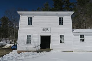
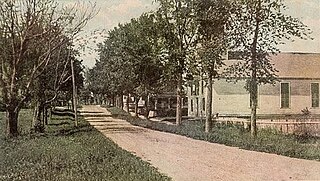
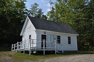
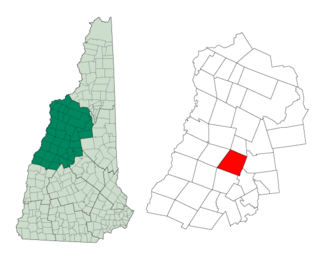
Orange is a town in Grafton County, New Hampshire, United States. The population was 277 at the 2020 census, down from 331 at the 2010 census.

<span class="mw-page-title-main">Piermont, New Hampshire</span> Town in New Hampshire, United States

Piermont is a town in Grafton County, New Hampshire, United States. The population was 769 at the 2020 census. It is home to Camp Walt Whitman and Kingswood Camp for Boys.

<span class="mw-page-title-main">Rumney, New Hampshire</span> Town in New Hampshire, United States

Rumney is a town in Grafton County, New Hampshire, United States. The population was 1,498 at the 2020 census. The town is located at the southern edge of the White Mountain National Forest.

<span class="mw-page-title-main">Warren, New Hampshire</span> Town in New Hampshire, United States

Warren is a town in Grafton County, New Hampshire, United States. The population was 825 at the 2020 census, down from 904 at the 2010 census. Warren includes the village of Glencliff. The Appalachian Trail crosses the town in the west.

<span class="mw-page-title-main">Acworth, New Hampshire</span> Town in New Hampshire, United States

Acworth is a town in Sullivan County, New Hampshire, United States. At the 2020 census, the town had a total population of 853.

<span class="mw-page-title-main">Lempster, New Hampshire</span> Place in New Hampshire, United States

Lempster is a town in Sullivan County, New Hampshire, United States. The population was 1,118 at the 2020 census. Settlements include the town center and the village of East Lempster.

<span class="mw-page-title-main">Wentworth, New Hampshire</span> Town in New Hampshire, United States

Wentworth is a town in Grafton County, New Hampshire, United States. The population was 845 at the 2020 census, down from 911 at the 2010 census. The town is home to Plummer's Ledge Natural Area, and part of the White Mountain National Forest is in the northeast. The town has a picturesque common, presided over by a Federal-style church and bordered by antique homes.

<span class="mw-page-title-main">Enfield, New Hampshire</span> Town in New Hampshire, United States

Enfield is a town in Grafton County, New Hampshire, United States. The population was 4,465 at the 2020 census. The town includes the villages of Enfield, Enfield Center, Upper Shaker Village, Lower Shaker Village, Lockehaven, and Montcalm.

References

  1. 1 2 "2021 U.S. Gazetteer Files – New Hampshire". United States Census Bureau. Retrieved November 23, 2021.
  2. 1 2 3 "Dorchester town, Grafton County, New Hampshire: 2020 DEC Redistricting Data (PL 94-171)". U.S. Census Bureau. Retrieved November 23, 2021.
  3. History of Dorchester, Grafton County, New Hampshire
  4. Coolidge, Austin J.; John B. Mansfield (1859). A History and Description of New England. Boston, Massachusetts. p. 467.{{cite book}}: CS1 maint: location missing publisher (link)
  5. Foster, Debra H.; Batorfalvy, Tatianna N.; Medalie, Laura (1995). Water Use in New Hampshire: An Activities Guide for Teachers. U.S. Department of the Interior and U.S. Geological Survey.
  6. "Census of Population and Housing". Census.gov. Retrieved June 4, 2016.
  7. "U.S. Census website". United States Census Bureau . Retrieved January 31, 2008.