Piermont, New Hampshire

Last updated

Piermont, New Hampshire
Town
View of Piermont, NH.jpg
Town center in 1913
Grafton-Piermont-NH.png
Coordinates: 43°58′11″N72°04′47″W / 43.96972°N 72.07972°W / 43.96972; -72.07972
Country United States
State New Hampshire
County Grafton
Incorporated 1764
Government
   Board of Selectmen
  • Colin Stubbings, Chair
  • Rick Daley
  • Wayne Godfrey
Area
[1]
  Total39.8 sq mi (103.2 km2)
  Land38.5 sq mi (99.6 km2)
  Water1.4 sq mi (3.6 km2)  3.49%
Elevation
568 ft (173 m)
Population
 (2020) [2]
  Total769
  Density20/sq mi (7.7/km2)
Time zone UTC-5 (Eastern)
  Summer (DST) UTC-4 (Eastern)
ZIP code
03779
Area code 603
FIPS code 33-61060
GNIS feature ID0873698
Website townofpiermontnh.org

Piermont is a town in Grafton County, New Hampshire, United States. The population was 769 at the 2020 census. [2] It is home to Camp Walt Whitman [3] and Kingswood Camp for Boys. [4]

Contents

History

Incorporated by Governor Benning Wentworth in 1764 and settled in 1768, the town takes its name from Italy's Piedmont. It had 426 residents in 1790, the year of the first census. [5]

Aaron Lane, who grew up in Piermont, was the first permanent settler in the Mojave Desert area now known as Victorville, California. A biography of Lane sheds light on life in Piermont during the mid-19th century. [6]

Geography

According to the United States Census Bureau, the town has a total area of 39.8 square miles (103.2 km2), of which 38.5 square miles (99.6 km2) are land and 1.4 square miles (3.6 km2) are water, comprising 3.49% of the town. [1] It is drained by Indian Pond Brook, Eastman Brook and Bean Brook, tributaries of the Connecticut River, which forms the western boundary. The southeastern corner of the town drains south to Upper Baker Pond in Orford, part of the Merrimack River watershed. Piermont's highest point is the summit of Piermont Mountain, at 2,717 feet (828 m) above sea level. The town is home to Lake Tarleton, which takes its name from its erstwhile owner, Colonel William Tarleton, who was a delegate to the Constitutional Convention of 1791. Lake Armington feeds Lake Tarleton from the south.

Piermont is bordered by the New Hampshire towns of Haverhill to the north, Warren to the east, Wentworth to the southeast, and Orford to the south. Bradford, Vermont, is across the Connecticut River to the west. Piermont is 27 miles (43 km) north of Lebanon and 33 miles (53 km) southwest of Littleton.

Transportation

Road

Piermont is crossed by New Hampshire state routes NH-10, NH-25 and NH-25C. Interstate 91 is accessible via neighboring Bradford, Vermont.

Air

Dean Memorial Airport in neighboring Haverhill is the closest airport. The closest commercial airport is Lebanon Municipal Airport in Lebanon. The closest international airport is Burlington International Airport in South Burlington, Vermont.

Rail

The closest Amtrak station is 30 miles (48 km) to the south in White River Junction, Vermont, providing service via the Vermonter line.

Demographics

Historical population
CensusPop.Note
1790 426
1800 67057.3%
1810 87730.9%
1820 1,01615.8%
1830 1,0422.6%
1840 1,0571.4%
1850 948−10.3%
1860 9490.1%
1870 792−16.5%
1880 752−5.1%
1890 709−5.7%
1900 637−10.2%
1910 592−7.1%
1920 577−2.5%
1930 475−17.7%
1940 53512.6%
1950 511−4.5%
1960 477−6.7%
1970 462−3.1%
1980 5079.7%
1990 62423.1%
2000 70913.6%
2010 79011.4%
2020 769−2.7%
U.S. Decennial Census [2] [7]

As of the census of 2010, [8] there were 790 people, 334 households, and 228 families residing in the town. The population density was 19.8 people per square mile (7.6/km2). There were 474 housing units at an average density of 11.9 per square mile (4.6/km2). The racial makeup of the town was 97.2% White, 0.1% African American, 0.9% Asian, 0.4% Native American and Alaskan Native, and 1.4% from two or more races. Hispanic or Latino of any race were 0.8% of the population.

There were 334 households in Piermont, out of which 24.6% had children under the age of 18 living with them, 57.8% were married couples living together, 7.5% had a female householder with no husband present, and 31.7% were non-families. 24.6% of all households were made up of individuals, and 9.6% had someone living alone who was 65 years of age or older. The average household size was 2.37, and the average family size was 2.83.

In the town, the population was spread out, with 19.0% under the age of 18, 5.1% between the ages of 18 and 24, 22.8% between 25 and 44, 36.3% between 45 and 64, and 16.8% who were 65 years of age or older. The median age was 46.8 years. The town was 49.4% male and 50.6% female.

For the period 2010–2014, the estimated median income for a household in the town was $72,841, and the median income for a family was $91,875. Male full-time workers had a median income of $49,688 versus $41,250 for females. The per capita income for the town was $38,089. About 3.4% of families and 6.8% of the total population were below the poverty line, including 6.3% of those under age 18 and 6.0% of those age 65 or over. [9]

Education

K–12

Piermont operates grades K–8 through the Piermont Village School. Piermont has no high schools in the town, and grades 9–12 are tuitioned to a number of area high schools. Students may also attend the technical schools Hartford Career & Technology Center in White River Junction, Vermont, and River Bend Career and Technical Center in Bradford, Vermont. [10] Students may also choose to attend St. Johnsbury Academy in St. Johnsbury, VT.

Higher education

The closest four-year public institution is Plymouth State University in Plymouth, New Hampshire. The closest four-year private institution is Dartmouth College in Hanover. The closest two-year community colleges are River Valley Community College in Claremont and Lakes Region Community College in Laconia.

Sites of interest

Notable people

Related Research Articles

<span class="mw-page-title-main">Hanover, New Hampshire</span> Town in the United States

Hanover is a town located along the Connecticut River in Grafton County, New Hampshire, United States. As of the 2020 census, its population was 11,870. The town is home to the Ivy League university Dartmouth College, the U.S. Army Corps of Engineers Cold Regions Research and Engineering Laboratory, and Hanover High School. The Appalachian Trail crosses the town, connecting with a number of trails and nature preserves.

<span class="mw-page-title-main">Grafton County, New Hampshire</span> County in New Hampshire, United States

Grafton County is a county in the U.S. state of New Hampshire. As of the 2020 census, the population was 91,118. Its county seat is the town of Haverhill. In 1972, the county courthouse and other offices were moved from Woodsville, a larger village within the town of Haverhill, to North Haverhill.

<span class="mw-page-title-main">Pittsburg, New Hampshire</span> Town in New Hampshire, United States

Pittsburg is a town in Coös County, New Hampshire, United States. The population was 800 at the 2020 census. It is the northernmost town in New Hampshire and the largest town by area in New England. U.S. Route 3 is the only major highway in the town, although the northern terminus of New Hampshire Route 145 also lies within Pittsburg.

<span class="mw-page-title-main">Bridgewater, New Hampshire</span> Town in New Hampshire, United States

Bridgewater is a town in Grafton County, New Hampshire, United States. The population was 1,160 at the 2020 census.

<span class="mw-page-title-main">Ellsworth, New Hampshire</span> Town in New Hampshire, United States

Ellsworth is a town in Grafton County, New Hampshire, United States. The population was 93 at the 2020 census.

<span class="mw-page-title-main">Haverhill, New Hampshire</span> Town in New Hampshire, United States

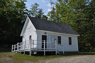
Haverhill is a town and the seat of Grafton County, New Hampshire, United States. The population was 4,585 at the 2020 census. Haverhill includes the villages of Woodsville, Pike, and North Haverhill, the historic town center at Haverhill Corner, and the district of Mountain Lakes. Located here are Bedell Bridge State Park, Black Mountain State Forest, Kinder Memorial Forest, and Oliverian Valley Wildlife Preserve. It is home to the annual North Haverhill Fair, and to a branch of the New Hampshire Community Technical Colleges.

<span class="mw-page-title-main">Hebron, New Hampshire</span> Town in New Hampshire, United States

Hebron is a town in Grafton County, New Hampshire, United States. The population was 632 at the 2020 census. Settlements include the town center and the village of East Hebron.

<span class="mw-page-title-main">Lyman, New Hampshire</span> Town in New Hampshire, United States

Lyman is a town in Grafton County, New Hampshire, United States. The population was 585 at the 2020 census.

<span class="mw-page-title-main">Lyme, New Hampshire</span> Town in New Hampshire, United States

Lyme is a town along the Connecticut River in Grafton County, New Hampshire, United States. The population was 1,745 as of the 2020 census. Lyme is home to the Chaffee Natural Conservation Area. The Dartmouth Skiway is in the eastern part of town, near the village of Lyme Center. The Appalachian Trail passes through the town's heavily wooded eastern end.

<span class="mw-page-title-main">Monroe, New Hampshire</span> Town in New Hampshire, United States

Monroe is a town in Grafton County, New Hampshire, United States. The population was 864 at the 2020 census, up from 788 at the 2010 census. The town is located along the Connecticut River, across from Barnet, Vermont. It was originally chartered as part of Lyman.

<span class="mw-page-title-main">Warren, New Hampshire</span> Town in New Hampshire, United States

Warren is a town in Grafton County, New Hampshire, United States. The population was 825 at the 2020 census, down from 904 at the 2010 census. Warren includes the village of Glencliff. The Appalachian Trail crosses the town in the west.

<span class="mw-page-title-main">Woodsville, New Hampshire</span> Census-designated place in New Hampshire, United States

Woodsville is a census-designated place (CDP) and the largest village in the town of Haverhill in Grafton County, New Hampshire, United States, along the Connecticut River at the mouth of the Ammonoosuc River. The population was 1,431 at the 2020 census. Although North Haverhill is now the county seat of Grafton County, the village of Woodsville has traditionally been considered the county seat, as the county courthouse was originally located there. The county buildings are now located halfway between Woodsville and the village of North Haverhill to the south.

<span class="mw-page-title-main">Wilmot, New Hampshire</span> Town in New Hampshire, United States

Wilmot is a town in Merrimack County, New Hampshire, United States. The population was 1,407 at the 2020 census. The town includes the communities of Wilmot, Wilmot Flat, and North Wilmot.

<span class="mw-page-title-main">Hampstead, New Hampshire</span> Place in New Hampshire, United States

Hampstead is a town in Rockingham County, New Hampshire, United States. The population was 8,998 at the 2020 census. Hampstead, which includes the village of East Hampstead, is home to a portion of the Rockingham Recreational Trail.

<span class="mw-page-title-main">Concord, Vermont</span> Town in Vermont, United States

Concord is a town in Essex County, Vermont, United States. The population was 1,141 at the 2020 census. It is part of the Berlin, NH–VT Micropolitan Statistical Area.

<span class="mw-page-title-main">Maidstone, Vermont</span> Town in Vermont, United States

Maidstone is a town in Essex County, Vermont, United States. As of the 2020 census, the town had a population of 211. It is part of the Berlin, NH–VT Micropolitan Statistical Area. There is no town center or gas station, but there is a town office building in the southern part of the town.

<span class="mw-page-title-main">New Hampshire Route 25</span> State highway in New Hampshire, US

New Hampshire Route 25 is a 96.62-mile (155.49 km) long east–west state highway in New Hampshire. It runs completely across the state from Vermont to Maine.

<span class="mw-page-title-main">Lake Tarleton</span>

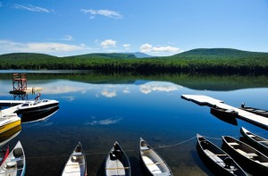
Lake Tarleton is a 334-acre (1.35 km2) water body located in Grafton County on the western edge of the White Mountains in New Hampshire, United States. The lake is located in the towns of Piermont and Warren. Water from Lake Tarleton flows via Eastman Brook west to the Connecticut River.

<span class="mw-page-title-main">Bradford, Vermont</span> Town in Vermont, United States

Bradford is a town in Orange County, Vermont, United States. The population was 2,790 at the 2020 census. Bradford is located on the county's eastern border, bordering both the Connecticut River and New Hampshire, and is a commercial center for some of its surrounding towns.

<span class="mw-page-title-main">Lake Armington</span> Lake in Grafton County, New Hampshire

Lake Armington is a 152-acre (0.62 km2) water body in the town of Piermont, in Grafton County on the western edge of the White Mountains in New Hampshire, United States. Water from Lake Armington flows north 0.2 miles (0.32 km) into Lake Tarleton, then west via Eastman Brook to the Connecticut River.

References

  1. 1 2 "2021 U.S. Gazetteer Files – New Hampshire". United States Census Bureau. Retrieved November 30, 2021.
  2. 1 2 3 "Piermont town, Grafton County, New Hampshire: 2020 DEC Redistricting Data (PL 94-171)". U.S. Census Bureau. Retrieved November 30, 2021.
  3. "Overnight Summer Camp for Kids in the Mountains of New Hampshire | Camp Walt Whitman". www.campwalt.com. Retrieved January 11, 2016.
  4. "Summer Camps In NH | Overnight Boys Camp | Kingswood Camp". kingswoodcamp.com. Retrieved January 11, 2016.
  5. Coolidge, Austin J.; John B. Mansfield (1859). A History and Description of New England. Boston, Massachusetts. pp. 615–616.{{cite book}}: CS1 maint: location missing publisher (link)
  6. Thompson, Richard D.; Thompson, Kathryn L. "Pioneer of the Mojave: The Life and Times of Aaron G. Lane". mojavehistory.com. Retrieved November 30, 2021.
  7. "Census of Population and Housing". Census.gov. Retrieved June 4, 2016.
  8. Bureau, U.S. Census. "U.S. Census website". United States Census Bureau . Retrieved January 18, 2016.
  9. "Selected Economic Characteristics: 2010-2014 American Community Survey 5-Year Estimates (DP03): Piermont town, Grafton County, New Hampshire". American Factfinder. U.S. Census Bureau. Archived from the original on February 13, 2020. Retrieved January 20, 2016.
  10. "Piermont NH - Community Profile | Economic & Labor Market Information Bureau | NH Employment Security". www.nhes.nh.gov. Retrieved January 11, 2016.