Chesterfield, New Hampshire

Last updated

Chesterfield, New Hampshire
Town
Congregational Church and Main Street, Chesterfield, NH.jpg
Main Street in 1909
Cheshire-Chesterfield-NH.png
Coordinates: 42°53′14″N72°28′13″W / 42.88722°N 72.47028°W / 42.88722; -72.47028
Country United States
State New Hampshire
County Cheshire
Incorporated 1752
Villages
Government
   Board of Selectmen
  • Fran Shippee
  • Gary Winn
  • Judy Idelkope
  Town AdministratorAlissa Thompson
Area
[1]
  Total47.5 sq mi (123.1 km2)
  Land45.6 sq mi (118.0 km2)
  Water2.0 sq mi (5.1 km2)  4.17%
Elevation
853 ft (260 m)
Population
 (2020) [2]
  Total3,552
  Density78/sq mi (30.1/km2)
Time zone UTC-5 (Eastern)
  Summer (DST) UTC-4 (Eastern)
ZIP codes
03443 (Chesterfield)
03462 (Spofford)
03466 (West Chesterfield)
Area code 603
FIPS code 33-12260
GNIS feature ID0873565
Website www.chesterfield.nh.gov

Chesterfield is a town in Cheshire County, New Hampshire, United States. The population was 3,552 at the 2020 census. [2] It includes the villages of Spofford and West Chesterfield. Chesterfield is home to Spofford Lake, Chesterfield Gorge Natural Area, and parts of Pisgah State Park and Wantastiquet Mountain State Forest.

Contents

History

Granted in 1735 by Governor Jonathan Belcher of Massachusetts, this town was the site of Fort Number 1, first in the line of forts bordering the Connecticut River. After the border between Massachusetts and New Hampshire was fixed, the town was incorporated on February 11, 1752 [3] by Governor Benning Wentworth as Chesterfield, named for Philip Stanhope, 4th Earl of Chesterfield. The first settlers were Moses Smith and William Thomas, who, with their families, came up the Connecticut in canoes, in the fall of 1761. Their chief subsistence through the winter and spring of their first year in the wilderness consisted of salmon and shad, of which there was a great abundance in the river, and deer, which were numerous in the forests. [3] The town contains some of the finest farmland in Cheshire County, yet once was also home to small manufacturing, notably spinning wheel parts and hand tools. [4]

In 1772, Philip Embury conducted the first Methodist religious services in New Hampshire at the James Robertson farm in Chesterfield, and in 1803, Francis Asbury preached here. Asbury Church is listed on the National Register of Historic Places and is recognized for its historic puritan design. Asbury Church is considered the "Mother Church of Methodism" in New Hampshire, and is the oldest Methodist church in the state. The town has had continual Methodist Sunday services for over 225 years. [5]

Chesterfield Academy, established in 1794, was for decades one of the most celebrated in the state. [6] Spofford Lake is one of the region's largest and oldest resorts.

Geography

According to the United States Census Bureau, the town has a total area of 47.5 square miles (123.1 km2), of which 45.6 square miles (118.0 km2) are land and 2.0 square miles (5.1 km2), or 4.17%, are water. [1] Chesterfield is bounded on the west by the Connecticut River. The highest point in the town is near its southern border, atop Davis Hill, at 1,427 feet (435 m) above sea level. Chesterfield lies fully within the Connecticut River watershed. [7]

The town is served by state routes 9 and 63.

Adjacent municipalities

Demographics

Historical population
CensusPop.Note
1790 1,905
1800 2,16113.4%
1810 1,839−14.9%
1820 2,11014.7%
1830 2,040−3.3%
1840 1,765−13.5%
1850 1,680−4.8%
1860 1,434−14.6%
1870 1,289−10.1%
1880 1,173−9.0%
1890 1,046−10.8%
1900 981−6.2%
1910 770−21.5%
1920 601−21.9%
1930 70417.1%
1940 591−16.1%
1950 97064.1%
1960 1,40544.8%
1970 1,81729.3%
1980 2,56140.9%
1990 3,11221.5%
2000 3,54213.8%
2010 3,6041.8%
2020 3,552−1.4%
U.S. Decennial Census [2] [8]

As of the census [9] of 2000, there were 3,542 people, 1,366 households, and 1,005 families residing in the town. The population density was 77.7 inhabitants per square mile (30.0/km2). There were 1,632 housing units at an average density of 35.8 per square mile (13.8/km2). The racial makeup of the town was 97.80% White, 0.23% African American, 0.56% Native American, 0.17% Asian, 0.08% from other races, and 1.16% from two or more races. Hispanic or Latino of any race were 0.56% of the population.

There were 1,366 households, out of which 32.7% had children under the age of 18 living with them, 63.5% were married couples living together, 6.9% had a female householder with no husband present, and 26.4% were non-families. 20.4% of all households were made up of individuals, and 6.6% had someone living alone who was 65 years of age or older. The average household size was 2.59 and the average family size was 3.01.

In the town, the population was spread out, with 25.9% under the age of 18, 4.9% from 18 to 24, 27.9% from 25 to 44, 30.4% from 45 to 64, and 10.9% who were 65 years of age or older. The median age was 40 years. For every 100 females, there were 103.8 males. For every 100 females age 18 and over, there were 100.2 males.

The median income for a household in the town was $51,351, and the median income for a family was $58,516. Males had a median income of $44,087 versus $26,547 for females. The per capita income for the town was $25,051. About 4.9% of families and 4.5% of the population were below the poverty line, including 4.5% of those under age 18 and 6.4% of those age 65 or over.

Sites of interest

Notable people

Related Research Articles

<span class="mw-page-title-main">Cheshire County, New Hampshire</span> County in New Hampshire, United States

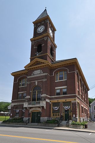
Cheshire County is a county in the southwestern corner of the U.S. state of New Hampshire. As of the 2020 census, the population was 76,458. Its county seat is the city of Keene. Cheshire was one of the five original counties of New Hampshire, and is named for the county of Cheshire in England. It was organized in 1771 at Keene. Sullivan County was created from the northern portion of Cheshire County in 1827.

<span class="mw-page-title-main">Chesterfield, Massachusetts</span> Town in Massachusetts, United States

Chesterfield is a rural hill town in Hampshire County, Massachusetts, United States, 26 miles (42 km) east of Pittsfield and 90 miles (140 km) west of Boston. The population was 1,186 at the 2020 census. It is part of the Springfield, Massachusetts Metropolitan Statistical Area.

<span class="mw-page-title-main">Alstead, New Hampshire</span> Town in New Hampshire, United States

Alstead is a town in Cheshire County, New Hampshire, United States. The population was 1,864 at the 2020 census. Alstead is home to Feuer State Forest.

<span class="mw-page-title-main">Gilsum, New Hampshire</span> Town in New Hampshire, United States

Gilsum is a town in Cheshire County, New Hampshire, United States. The population was 752 at the 2020 census. Home to Bear's Den Natural Area, Gilsum includes Gilsum Lower Village.

<span class="mw-page-title-main">Marlow, New Hampshire</span> Town in New Hampshire, United States

Marlow is a town in Cheshire County, New Hampshire, United States. The population was 749 at the 2020 census. Marlow is home to Honey Brook State Forest.

<span class="mw-page-title-main">Nelson, New Hampshire</span> Town in New Hampshire, United States

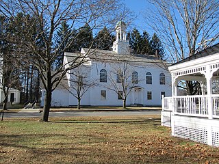
Nelson is a town in Cheshire County, New Hampshire, United States. The population was 629 at the 2020 census, down from 729 at the 2010 census. Nelson includes the village of Munsonville.

<span class="mw-page-title-main">Richmond, New Hampshire</span> Town in New Hampshire, United States

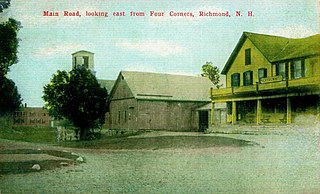
Richmond is a town in Cheshire County, New Hampshire, United States. The population was 1,197 at the 2020 census.

<span class="mw-page-title-main">Rindge, New Hampshire</span> Town in New Hampshire, United States

Rindge is a town in Cheshire County, New Hampshire, United States. The population was 6,476 at the 2020 census, up from 6,014 at the 2010 census. Rindge is home to Franklin Pierce University, the Cathedral of the Pines and part of Annett State Forest.

<span class="mw-page-title-main">Stoddard, New Hampshire</span> Town in New Hampshire, United States

Stoddard is a town in Cheshire County, New Hampshire, United States. The population was 1,374 at the 2020 census, up from 1,232 at the 2010 census.

<span class="mw-page-title-main">Sullivan, New Hampshire</span> Town in New Hampshire, United States

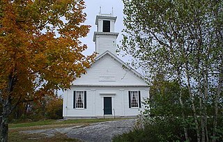
Sullivan is a town in Cheshire County, New Hampshire, United States. The population was 658 at the 2020 census. It includes the villages of East Sullivan and Ellisville.

<span class="mw-page-title-main">Swanzey, New Hampshire</span> Town in New Hampshire, United States

Swanzey is a town in Cheshire County, New Hampshire, United States. The population was 7,270 at the 2020 census. In addition to the town center, Swanzey includes the villages of East Swanzey, West Swanzey, North Swanzey and Westport.

<span class="mw-page-title-main">Walpole, New Hampshire</span> Town in New Hampshire, United States

Walpole is a town in Cheshire County, New Hampshire, United States. The population was 3,633 at the 2020 census.

<span class="mw-page-title-main">Westmoreland, New Hampshire</span> Town in New Hampshire, United States

Westmoreland is a town in Cheshire County, New Hampshire, United States. The population was 1,706 at the 2020 census, down from 1,874 at the 2010 census. Westmoreland is historically an agricultural town, with much arable farmland.

<span class="mw-page-title-main">Northumberland, New Hampshire</span> Town in New Hampshire, United States

Northumberland is a town located in western Coös County, New Hampshire, United States, north of Lancaster. It is part of the Berlin, NH–VT micropolitan statistical area. As of the 2020 census, the town population was 2,126, of whom 1,068 lived in the village of Groveton.

<span class="mw-page-title-main">Bath, New Hampshire</span> Town in New Hampshire, United States

Bath is a town in Grafton County, New Hampshire, United States. The population was 1,077 at the 2020 census, unchanged from the 2010 census. Now a tourist destination and commuter town for Littleton, the town is noted for its historic architecture, including the Brick Store and three covered bridges. Bath includes the village of Swiftwater and part of the district known as Mountain Lakes.

<span class="mw-page-title-main">New Durham, New Hampshire</span> Town in New Hampshire, United States

New Durham is a town in Strafford County, New Hampshire, United States. The population was 2,693 at the 2020 census. It is drained by the Merrymeeting, Cocheco and Ela rivers, and is known for Merrymeeting Lake. New Durham is home to the Powder Mill Fish Hatchery, located on Merrymeeting Road. Also located here is the Lions Club's Camp Pride, a camp for children and adults with special needs.

<span class="mw-page-title-main">Hinsdale, New Hampshire</span> Town in New Hampshire, United States

Hinsdale is a town in Cheshire County, New Hampshire, United States. The population was 3,948 at the 2020 census. Hinsdale is home to part of Pisgah State Park in the northeast, and part of Wantastiquet Mountain State Forest in the northwest.

<span class="mw-page-title-main">Jaffrey, New Hampshire</span> Town in New Hampshire, United States

Jaffrey is a town in Cheshire County, New Hampshire, United States. The population was 5,320 at the 2020 census.

<span class="mw-page-title-main">Marlborough, New Hampshire</span> Town in New Hampshire, United States

Marlborough is a town in Cheshire County, New Hampshire, United States. The population was 2,096 at the 2020 census. The town is home to the Kensan-Devan Wildlife Sanctuary at Meetinghouse Pond.

<span class="mw-page-title-main">Winchester, New Hampshire</span> Town in New Hampshire, United States

Winchester is a town in Cheshire County, New Hampshire, United States. The population was 4,150 at the 2020 census. The primary community in the town, where 1,606 people resided at the 2020 census, is defined by the U.S. Census Bureau as the Winchester census-designated place (CDP). The town also includes the village of Ashuelot and part of Pisgah State Park.

References

  1. 1 2 "2021 U.S. Gazetteer Files – New Hampshire". United States Census Bureau. Retrieved November 3, 2021.
  2. 1 2 3 "Chesterfield town, Cheshire County, New Hampshire: 2020 DEC Redistricting Data (PL 94-171)". U.S. Census Bureau. Retrieved November 3, 2021.
  3. 1 2 Article in Statistics and Gazetteer of New-Hampshire (1875)
  4. Coolidge, Austin J.; John B. Mansfield (1859). A History and Description of New England. Boston, Massachusetts: A.J. Coolidge. pp.  444–445. coolidge mansfield history description new england 1859.
  5. History of Asbury United Methodist Church Archived January 13, 2010, at the Wayback Machine
  6. History of Chesterfield, Cheshire County, New Hampshire
  7. Foster, Debra H.; Batorfalvy, Tatianna N.; Medalie, Laura (1995). Water Use in New Hampshire: An Activities Guide for Teachers. U.S. Department of the Interior and U.S. Geological Survey.
  8. "Census of Population and Housing". Census.gov. Retrieved June 4, 2016.
  9. "U.S. Census website". United States Census Bureau . Retrieved January 31, 2008.

Further reading