Stoddard, New Hampshire

Last updated

Stoddard, New Hampshire
Town
Stone Arch Bridge - Stoddard, NH.jpg
Stone Arch Bridge
Stoddard Town Seal.png
Cheshire-Stoddard-NH.png
Location in Cheshire County, New Hampshire
Coordinates: 43°04′43″N72°06′52″W / 43.07861°N 72.11444°W / 43.07861; -72.11444
CountryUnited States
State New Hampshire
County Cheshire
Incorporated 1774
Villages
  • Stoddard
  • Mill Village
Government
   Board of Selectmen
  • Christopher Madden, Chair
  • Robert Fee
  • Terri LaRoche
  Town AdministratorMichelle L. Pong
Area
[1]
  Total53.1 sq mi (137.4 km2)
  Land50.9 sq mi (131.9 km2)
  Water2.1 sq mi (5.5 km2)  3.99%
Elevation
1,427 ft (435 m)
Population
 (2020) [2]
  Total1,374
  Density27/sq mi (10.4/km2)
Time zone UTC-5 (Eastern)
  Summer (DST) UTC-4 (Eastern)
ZIP codes
03464 (Stoddard)
03457 (Nelson)
Area code 603
FIPS code 33-73700
GNIS feature ID0873725
Website www.stoddardnh.org

Stoddard is a town in Cheshire County, New Hampshire, United States. The population was 1,374 at the 2020 census, [2] up from 1,232 at the 2010 census. [3]

Contents

Between 1842 and 1873, the town was home to four glass manufacturers. The glass produced by these works, now known as Stoddard glass, is noted for its deep amber colors and design. Stoddard glass products are highly prized by collectors. [4]

History

This territory was first granted in 1752 to Colonel Sampson Stoddard of Chelmsford, Massachusetts, and others as "Monadnock Number 7". It was known locally as "Limerick" before being incorporated as Stoddard in 1774, in honor of Colonel Stoddard. [5]

Colonel Stoddard was appointed to survey southwestern New Hampshire by the colonial government, receiving several land grants for the service. One of his surveying assistants was Benjamin Pierce, father of U.S. President Franklin Pierce. Colonel Stoddard never lived in the town of Stoddard. [6]

The town was first settled in 1768 by John and Martha Taggart, immigrants from Derry, Ireland. Three years later, the Richardson family joined the Taggarts in Stoddard. By 1774, the town had 24 residents. [7]

The first census taken in Stoddard, in 1790, reported 701 residents. [8] The town's first schoolhouses were built in 1792. [9] The first post office was established in 1822; Isaac Duncan was the first Postmaster. [9]

In 1800, Stoddard's 1,148 residents outnumbered those of the nearby county seat of Keene. During Stoddard's glass-manufacturing years, 800 people were employed by the industry. [10] After the Stoddard glass industry ended in the early 1870s, the town's population declined; by 1960, the census recorded 146 residents. [11] As of 2010, the town had 1,232 residents. [3]

Stoddard glass

Between 1840 and 1873, Stoddard was a center of glass manufacturing, home to four glass factories whose products are prized by collectors today. The town's abundant forests fed the industry's need for the 1,200 °F (650 °C) temperatures necessary to melt sand into glass. Stoddard also had plenty of clear, fine sand. The sand's trace minerals gave Stoddard glass its unique hues: manganese produced the olive green and amber colors most closely associated with Stoddard glass, and oxide of gold created a red-amber glass. [10]

The glass houses were located in two settlements within Stoddard: Joseph Foster's and the South Stoddard Glass Company were located in South Stoddard, which was located near the present-day intersection of state Routes 9 and 123. The Granite Glass Company and the New Granite Glass Works were located in Mill Village, near the present town center. [12]

Among the wide variety of glass pieces turned out by the glass houses were Masonic flasks, containers for liquor and patent medicines, and bottles for mineral water bottled in Saratoga Springs, New York. [13] However, the fame of Stoddard glass does not come primarily from these commercial items, but from the "off-blown" pieces made by glassblowers at the end of the workday using leftover glass. These items, sometimes called "whimseys", could be anything desired by the glassblower, and were the property of the glassblower. [14]

Several factors led to the demise of Stoddard's glass industry in the early 1870s. Other manufacturers had mastered the chemistry needed to create clear glass in quantity; gas and coal were now viable fuels for glassworks, eliminating the need for nearby forests; and improvements in mechanical manufacturing techniques made hand-blown glass economically unviable. [15] The silica in Stoddard's sand prevented its use in making clear glass, which was in high demand after it became viable for bottles and glassware following the Civil War. [16]

Geography

According to the United States Census Bureau, the town has a total area of 53.1 square miles (137.4 km2), of which 50.9 square miles (131.9 km2) are land and 2.1 square miles (5.5 km2) are water, comprising 3.99% of the town. [1] The western portion of the town is drained by tributaries of the Ashuelot River, which flows to the Connecticut River. The central and eastern portions of town drain to the North Branch of the Contoocook River and eventually to the Merrimack River. Major water bodies in the town include Highland Lake and Island Pond in the northeast and Granite Lake on the southern border.

The Monadnock-Sunapee Greenway passes through the western side of the town (near Center Pond) and continues onward toward the highest point in Stoddard, the summit of Pitcher Mountain (at 2,162 feet (659 m) above sea level).

The town is crossed by New Hampshire Route 9 from northeast to southwest, and by New Hampshire Route 123, which passes through the town center, from southeast to northwest.

Adjacent municipalities

Historical population
CensusPop.Note
1790 701
1800 1,14863.8%
1810 1,132−1.4%
1820 1,2036.3%
1830 1,159−3.7%
1840 1,006−13.2%
1850 1,1059.8%
1860 944−14.6%
1870 667−29.3%
1880 553−17.1%
1890 400−27.7%
1900 367−8.2%
1910 257−30.0%
1920 213−17.1%
1930 113−46.9%
1940 21892.9%
1950 200−8.3%
1960 146−27.0%
1970 24265.8%
1980 48299.2%
1990 62229.0%
2000 92849.2%
2010 1,23232.8%
2020 1,37411.5%
U.S. Decennial Census [2] [17]

Demographics

As of the census [18] of 2000, there were 928 people, 400 households, and 268 families residing in the town. The population density was 18.2 people per square mile (7.0/km2). There were 939 housing units at an average density of 18.5 per square mile (7.1/km2). The racial makeup of the town was 96.88% White, 0.32% African American, 1.29% Native American, 0.43% Asian, 0.11% Pacific Islander, 0.22% from other races, and 0.75% from two or more races. Hispanic or Latino of any race were 0.54% of the population.

There were 400 households, out of which 22.8% had children under the age of 18 living with them, 58.5% were married couples living together, 4.3% had a female householder with no husband present, and 33.0% were non-families. 25.3% of all households were made up of individuals, and 9.3% had someone living alone who was 65 years of age or older. The average household size was 2.32 and the average family size was 2.76.

In the town, the population was spread out, with 20.2% under the age of 18, 4.6% from 18 to 24, 29.5% from 25 to 44, 30.6% from 45 to 64, and 15.1% who were 65 years of age or older. The median age was 43 years. For every 100 females, there were 104.9 males. For every 100 females age 18 and over, there were 102.5 males.

The median income for a household in the town was $37,639, and the median income for a family was $48,125. Males had a median income of $31,343 versus $25,227 for females. The per capita income for the town was $19,617. About 5.3% of families and 8.6% of the population were below the poverty line, including 10.3% of those under age 18 and 10.8% of those age 65 or over.

Education

Residents of Stoddard attending public high and middle schools go to Keene High School and Keene Middle School, respectively, in Keene. Public elementary school students attend James M. Faulkner Elementary School in Stoddard.

See also

Related Research Articles

<span class="mw-page-title-main">Cheshire County, New Hampshire</span> County in New Hampshire, United States

Cheshire County is a county in the southwestern corner of the U.S. state of New Hampshire. As of the 2020 census, the population was 76,458. Its county seat is the city of Keene. Cheshire was one of the five original counties of New Hampshire, and is named for the county of Cheshire in England. It was organized in 1771 at Keene. Sullivan County was created from the northern portion of Cheshire County in 1827.

<span class="mw-page-title-main">Baldwin, Maine</span> Town in the state of Maine, United States

Baldwin is a town in Cumberland County, Maine, United States. The population was 1,520 at the 2020 census. It is part of the Portland–South Portland–Biddeford, Maine, metropolitan statistical area.

<span class="mw-page-title-main">Chesterfield, New Hampshire</span> Town in New Hampshire, United States

Chesterfield is a town in Cheshire County, New Hampshire, United States. The population was 3,552 at the 2020 census. It includes the villages of Spofford and West Chesterfield. Chesterfield is home to Spofford Lake, Chesterfield Gorge Natural Area, and parts of Pisgah State Park and Wantastiquet Mountain State Forest.

<span class="mw-page-title-main">Gilsum, New Hampshire</span> Town in New Hampshire, United States

Gilsum is a town in Cheshire County, New Hampshire, United States. The population was 752 at the 2020 census. Home to Bear's Den Natural Area, Gilsum includes Gilsum Lower Village.

<span class="mw-page-title-main">Marlow, New Hampshire</span> Town in New Hampshire, United States

Marlow is a town in Cheshire County, New Hampshire, United States. The population was 749 at the 2020 census. Marlow is home to Honey Brook State Forest.

<span class="mw-page-title-main">Nelson, New Hampshire</span> Town in New Hampshire, United States

Nelson is a town in Cheshire County, New Hampshire, United States. The population was 629 at the 2020 census, down from 729 at the 2010 census. Nelson includes the village of Munsonville.

<span class="mw-page-title-main">Richmond, New Hampshire</span> Town in New Hampshire, United States

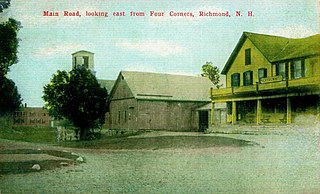
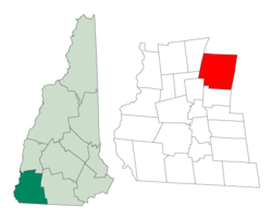
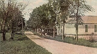
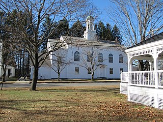
Richmond is a town in Cheshire County, New Hampshire, United States. The population was 1,197 at the 2020 census.

<span class="mw-page-title-main">Rindge, New Hampshire</span> Town in New Hampshire, United States

Rindge is a town in Cheshire County, New Hampshire, United States. The population was 6,476 at the 2020 census, up from 6,014 at the 2010 census. Rindge is home to Franklin Pierce University, the Cathedral of the Pines and part of Annett State Forest.

<span class="mw-page-title-main">Roxbury, New Hampshire</span> Town in New Hampshire, United States

Roxbury is a town in Cheshire County, New Hampshire, United States. The population was 220 at the 2020 census.

<span class="mw-page-title-main">Sullivan, New Hampshire</span> Town in New Hampshire, United States

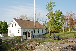
Sullivan is a town in Cheshire County, New Hampshire, United States. The population was 658 at the 2020 census. It includes the villages of East Sullivan and Ellisville.

<span class="mw-page-title-main">Surry, New Hampshire</span> Town in New Hampshire, United States

Surry is a town in Cheshire County, New Hampshire, United States. The population was 820 at the 2020 census, up from 732 at the 2010 census.

<span class="mw-page-title-main">Swanzey, New Hampshire</span> Town in New Hampshire, United States

Swanzey is a town in Cheshire County, New Hampshire, United States. The population was 7,270 at the 2020 census. In addition to the town center, Swanzey includes the villages of East Swanzey, West Swanzey, North Swanzey and Westport.

<span class="mw-page-title-main">Troy, New Hampshire</span> Town in New Hampshire, United States

Troy is a town in Cheshire County, New Hampshire, United States. The population was 2,130 at the 2020 census. It is situated west of Mount Monadnock.

<span class="mw-page-title-main">Walpole, New Hampshire</span> Town in New Hampshire, United States

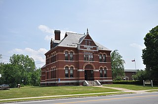
Walpole is a town in Cheshire County, New Hampshire, United States. The population was 3,633 at the 2020 census.

<span class="mw-page-title-main">Westmoreland, New Hampshire</span> Town in New Hampshire, United States

Westmoreland is a town in Cheshire County, New Hampshire, United States. The population was 1,706 at the 2020 census, down from 1,874 at the 2010 census. Westmoreland is historically an agricultural town, with much arable farmland.

<span class="mw-page-title-main">Lyndeborough, New Hampshire</span> Town in New Hampshire, United States

Lyndeborough is a town in Hillsborough County, New Hampshire, United States. The population was 1,702 at the 2020 census.

<span class="mw-page-title-main">Hinsdale, New Hampshire</span> Town in New Hampshire, United States

Hinsdale is a town in Cheshire County, New Hampshire, United States. The population was 3,948 at the 2020 census. Hinsdale is home to part of Pisgah State Park in the northeast, and part of Wantastiquet Mountain State Forest in the northwest.

<span class="mw-page-title-main">Jaffrey, New Hampshire</span> Town in New Hampshire, United States

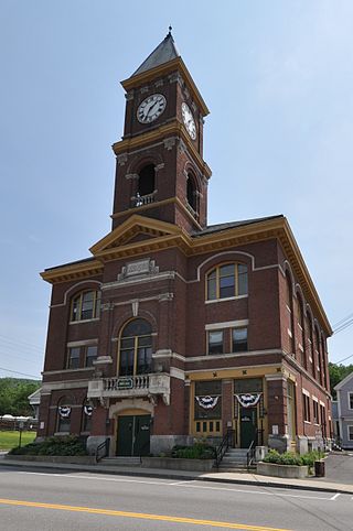
Jaffrey is a town in Cheshire County, New Hampshire, United States. The population was 5,320 at the 2020 census.

<span class="mw-page-title-main">Marlborough, New Hampshire</span> Town in New Hampshire, United States

Marlborough is a town in Cheshire County, New Hampshire, United States. The population was 2,096 at the 2020 census. The town is home to the Kensan-Devan Wildlife Sanctuary at Meetinghouse Pond.

<span class="mw-page-title-main">Winchester, New Hampshire</span> Town in New Hampshire, United States

Winchester is a town in Cheshire County, New Hampshire, United States. The population was 4,150 at the 2020 census. The primary community in the town, where 1,606 people resided at the 2020 census, is defined by the U.S. Census Bureau as the Winchester census-designated place (CDP). The town also includes the village of Ashuelot and part of Pisgah State Park.

References

  1. 1 2 "2021 U.S. Gazetteer Files – New Hampshire". United States Census Bureau. Retrieved November 4, 2021.
  2. 1 2 3 "Stoddard town, Cheshire County, New Hampshire: 2020 DEC Redistricting Data (PL 94-171)". U.S. Census Bureau. Retrieved November 4, 2021.
  3. 1 2 "Geographic Identifiers: 2010 Census Redistricting Data (Public Law 94-171) Summary File, Stoddard town, Cheshire County, New Hampshire". American FactFinder. United States Census Bureau. 2010. Archived from the original on February 12, 2020. Retrieved April 9, 2011.
  4. Stoddard Glass (Historical marker no. 52). Route 9, Stoddard, New Hampshire: State of New Hampshire. 1968. Retrieved December 29, 2010.{{cite sign}}: CS1 maint: location (link)
  5. Coolidge, Austin J.; John B. Mansfield (1859). A History and Description of New England. Boston, Massachusetts: A.J. Coolidge. p.  655. coolidge mansfield history description new england 1859.
  6. Field, Anne E. (1975). On the Trail of Stoddard Glass. Joseph Binko (photos). Dublin, New Hampshire: William L. Bauhan. p. 16. ISBN   0-87233-021-4.
  7. Field, Stoddard Glass, pp. 16–17
  8. "Heads of Families at the First Census of the United States Taken in the Year 1790: New Hampshire" (PDF). Government Printing Office. 1907. Archived (PDF) from the original on January 22, 2005. Retrieved April 11, 2011.
  9. 1 2 Field, Stoddard Glass, p. 17
  10. 1 2 Field, Stoddard Glass, p. 19
  11. "Population of NH Towns and Counties 1960–2010". NH Office of Energy and Planning – State Data Center. March 23, 2011. Retrieved April 11, 2011.
  12. Field, Stoddard Glass, p. 26
  13. Field, Stoddard Glass, 28–37.
  14. Field, Stoddard Glass, p. 40.
  15. Field, Stoddard Glass, pp. 19–20
  16. Field, Stoddard Glass, p. 32.
  17. "Census of Population and Housing". Census.gov. Retrieved June 4, 2016.
  18. "U.S. Census website". United States Census Bureau . Retrieved January 31, 2008.