Roxbury, New Hampshire

Last updated

Roxbury, New Hampshire
Town
Cheshire-Roxbury-NH.png
Coordinates: 42°57′18″N72°12′21″W / 42.95500°N 72.20583°W / 42.95500; -72.20583
Country United States
State New Hampshire
County Cheshire
Incorporated 1812
VillageRoxbury Center
Government
   Board of Selectmen
  • Janice Albano
  • Tim O'Brien
  • Mark Funk
Area
[1]
  Total12.2 sq mi (31.6 km2)
  Land11.9 sq mi (30.8 km2)
  Water0.3 sq mi (0.8 km2)  2.40%
Elevation
1,375 ft (419 m)
Population
 (2020) [2]
  Total220
  Density18/sq mi (7.0/km2)
Time zone UTC-5 (Eastern)
  Summer (DST) UTC-4 (Eastern)
ZIP codes
03431 (Keene)
03445 (Sullivan)
03455 (Marlborough)
03457 (Nelson)
Area code 603
FIPS code 33-65700
GNIS feature ID0873710
Website www.roxburynh.org

Roxbury is a town in Cheshire County, New Hampshire, United States. The population was 220 at the 2020 census. [2]

Contents

History

The smallest town in Cheshire County, Roxbury was incorporated in 1812 from portions of Nelson, Marlborough, and Keene. By then, settlers had established agriculture among the rolling hillsides in the area, and a community had developed at what is now called Roxbury Center. It was a "hill farm" community with some scattered small mills. Roxbury's granite quarries, among the most extensive in the Granite State at the time, provided some of the stone for the capitol building of New York in Albany.

Much of Roxbury was abandoned in the Civil War, as a very high percentage of its male population was killed in battle. Other residents left after the Civil War to seek a better life in local mill villages or in the American Midwest. Otter Brook Lake, constructed by the Army Corps of Engineers in 1956–1958 to control flooding in the Ashuelot and Connecticut River valleys, occupies part of the town's western boundary.

Geography

According to the United States Census Bureau, the town has a total area of 12.2 square miles (31.6 km2), of which 11.9 square miles (30.8 km2) are land and 0.3 square miles (0.8 km2) are water, comprising 2.40% of the town. [1] The highest point in Roxbury is the summit Bassett Hill, at 1,644 feet (501 m) above sea level.

Granite Gorge Ski Area on Pinnacle Mountain is located in the town's northwestern corner, along New Hampshire Route 9.

Batcheller's Cave is noted for its place in history as the hiding place of Breed Batcheller, who was edged out of town for failing to join the rebellion against the crown during the Revolutionary War. [3]

Adjacent municipalities

Demographics

Historical population
CensusPop.Note
1820 366
1830 322−12.0%
1840 286−11.2%
1850 260−9.1%
1860 212−18.5%
1870 174−17.9%
1880 126−27.6%
1890 1292.4%
1900 100−22.5%
1910 66−34.0%
1920 56−15.2%
1930 53−5.4%
1940 113113.2%
1950 1173.5%
1960 13717.1%
1970 16117.5%
1980 19018.0%
1990 24830.5%
2000 237−4.4%
2010 229−3.4%
2020 220−3.9%
U.S. Decennial Census [2] [4]
Otter Brook Lake in Roxbury OtterBrook.jpg
Otter Brook Lake in Roxbury

At the 2000 census, [5] there were 237 people, 89 households and 66 families residing in the town. The population density was 19.9 per square mile (7.7/km2). There were 90 housing units at an average density of 7.6 per square mile (2.9/km2). The racial makeup of the town was 98.73% White, 0.42% Asian, and 0.84% from two or more races.

There were 89 households, of which 32.6% had children under the age of 18 living with them, 67.4% were married couples living together, 6.7% had a female householder with no husband present, and 25.8% were non-families. 20.2% of all households were made up of individuals, and 5.6% had someone living alone who was 65 years of age or older. The average household size was 2.66 and the average family size was 3.12.

25.3% of the population were under the age of 18, 3.8% from 18 to 24, 28.7% from 25 to 44, 32.9% from 45 to 64, and 9.3% who were 65 years of age or older. The median age was 41 years. For every 100 females, there were 99.2 males. For every 100 females age 18 and over, there were 88.3 males.

The median household income was $49,375 and the median family income was $56,875. Males had a median income of $33,984 and females $23,750. The per capita income for the town was $21,124. None of the families and 0.9% of the population were living below the poverty line.

Notable people

Related Research Articles

<span class="mw-page-title-main">Cheshire County, New Hampshire</span> County in New Hampshire, United States

Cheshire County is a county in the southwestern corner of the U.S. state of New Hampshire. As of the 2020 census, the population was 76,458. Its county seat is the city of Keene. Cheshire was one of the five original counties of New Hampshire, and is named for the county of Cheshire in England. It was organized in 1771 at Keene. Sullivan County was created from the northern portion of Cheshire County in 1827.

<span class="mw-page-title-main">Roxbury, Maine</span> Town in the state of Maine, United States

Roxbury is a town in Oxford County, Maine, United States. The population was 361 at the 2020 census. Ellis Pond is popular with recreational fishermen.

<span class="mw-page-title-main">Chesterfield, New Hampshire</span> Town in New Hampshire, United States

Chesterfield is a town in Cheshire County, New Hampshire, United States. The population was 3,552 at the 2020 census. It includes the villages of Spofford and West Chesterfield. Chesterfield is home to Spofford Lake, Chesterfield Gorge Natural Area, and parts of Pisgah State Park and Wantastiquet Mountain State Forest.

<span class="mw-page-title-main">Gilsum, New Hampshire</span> Town in New Hampshire, United States

Gilsum is a town in Cheshire County, New Hampshire, United States. The population was 752 at the 2020 census. Home to Bear's Den Natural Area, Gilsum includes Gilsum Lower Village.

<span class="mw-page-title-main">Harrisville, New Hampshire</span> Town in New Hampshire, United States

Harrisville is a town in Cheshire County, New Hampshire, United States. Besides the town center, it also includes the villages of Chesham and Eastview. The population of the town was 984 at the 2020 census.

<span class="mw-page-title-main">Marlow, New Hampshire</span> Town in New Hampshire, United States

Marlow is a town in Cheshire County, New Hampshire, United States. The population was 749 at the 2020 census. Marlow is home to Honey Brook State Forest.

<span class="mw-page-title-main">Nelson, New Hampshire</span> Town in New Hampshire, United States

Nelson is a town in Cheshire County, New Hampshire, United States. The population was 629 at the 2020 census, down from 729 at the 2010 census. Nelson includes the village of Munsonville.

<span class="mw-page-title-main">Richmond, New Hampshire</span> Town in New Hampshire, United States

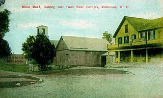
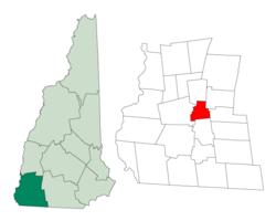
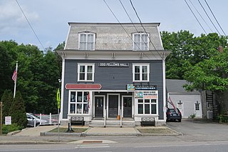
Richmond is a town in Cheshire County, New Hampshire, United States. The population was 1,197 at the 2020 census.

<span class="mw-page-title-main">Stoddard, New Hampshire</span> Town in New Hampshire, United States

Stoddard is a town in Cheshire County, New Hampshire, United States. The population was 1,374 at the 2020 census, up from 1,232 at the 2010 census.

<span class="mw-page-title-main">Sullivan, New Hampshire</span> Town in New Hampshire, United States

Sullivan is a town in Cheshire County, New Hampshire, United States. The population was 658 at the 2020 census. It includes the villages of East Sullivan and Ellisville.

<span class="mw-page-title-main">Surry, New Hampshire</span> Town in New Hampshire, United States

Surry is a town in Cheshire County, New Hampshire, United States. The population was 820 at the 2020 census, up from 732 at the 2010 census.

<span class="mw-page-title-main">Swanzey, New Hampshire</span> Town in New Hampshire, United States

Swanzey is a town in Cheshire County, New Hampshire, United States. The population was 7,270 at the 2020 census. In addition to the town center, Swanzey includes the villages of East Swanzey, West Swanzey, North Swanzey and Westport.

<span class="mw-page-title-main">Troy, New Hampshire</span> Town in New Hampshire, United States

Troy is a town in Cheshire County, New Hampshire, United States. The population was 2,130 at the 2020 census. It is situated west of Mount Monadnock.

<span class="mw-page-title-main">West Swanzey, New Hampshire</span> Census-designated place in New Hampshire, United States

West Swanzey is a census-designated place (CDP) in the town of Swanzey within Cheshire County, New Hampshire, United States. The population was 1,281 at the 2020 census. It is the largest village in the town of Swanzey.

<span class="mw-page-title-main">Westmoreland, New Hampshire</span> Town in New Hampshire, United States

Westmoreland is a town in Cheshire County, New Hampshire, United States. The population was 1,706 at the 2020 census, down from 1,874 at the 2010 census. Westmoreland is historically an agricultural town, with much arable farmland.

<span class="mw-page-title-main">Jaffrey (CDP), New Hampshire</span> Census-designated place in New Hampshire, United States

Jaffrey is a census-designated place (CDP) and the main village in the town of Jaffrey in Cheshire County, New Hampshire, United States. The population of the CDP was 3,058 at the 2020 census, out of 5,320 in the entire town of Jaffrey.

<span class="mw-page-title-main">Marlborough (CDP), New Hampshire</span> Census-designated place in New Hampshire, United States

Marlborough is a census-designated place (CDP) and the main village in the town of Marlborough in Cheshire County, New Hampshire, United States. The population of the CDP was 1,066 at the 2020 census, out of 2,096 in the entire town.

<span class="mw-page-title-main">Marlborough, New Hampshire</span> Town in New Hampshire, United States

Marlborough is a town in Cheshire County, New Hampshire, United States. The population was 2,096 at the 2020 census. The town is home to the Kensan-Devan Wildlife Sanctuary at Meetinghouse Pond.

<span class="mw-page-title-main">Winchester (CDP), New Hampshire</span> Census-designated place in New Hampshire, United States

Winchester is a census-designated place (CDP) and the main village in the town of Winchester in Cheshire County, New Hampshire, United States. The population of the CDP was 1,606 at the 2020 census, compared to 4,150 in the entire town.

<span class="mw-page-title-main">Walpole (CDP), New Hampshire</span> Census-designated place in New Hampshire, United States

Walpole is a census-designated place (CDP) and the central village in the town of Walpole in Cheshire County, New Hampshire, United States. The population of the CDP was 573 at the 2020 census, compared to 3,633 in the entire town.

References

  1. 1 2 "2021 U.S. Gazetteer Files – New Hampshire". United States Census Bureau. Retrieved November 4, 2021.
  2. 1 2 3 "Roxbury town, Cheshire County, New Hampshire: 2020 DEC Redistricting Data (PL 94-171)". U.S. Census Bureau. Retrieved November 4, 2021.
  3. "History of Roxbury". Town of Roxbury - A good dam town. Town of Roxbury. Archived from the original on October 18, 2015. Retrieved October 28, 2015.
  4. "Census of Population and Housing". Census.gov. Retrieved June 4, 2016.
  5. "U.S. Census website". United States Census Bureau . Retrieved January 31, 2008.