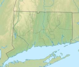
Middlefield is a town in Middlesex County, Connecticut, United States. The town is part of the Lower Connecticut River Valley Planning Region. The population was 4,217 at the 2020 census. The town includes the village of Rockfall in the northeast section.

The Connecticut River is the longest river in the New England region of the United States, flowing roughly southward for 406 miles (653 km) through four states. It rises 300 yards south of the U.S. border with Quebec, Canada, and discharges at Long Island Sound. Its watershed encompasses 11,260 square miles (29,200 km2), covering parts of five U.S. states and one Canadian province, via 148 tributaries, 38 of which are major rivers. It produces 70% of Long Island Sound's fresh water, discharging at 18,400 cubic feet (520 m3) per second.

The Connecticut Lakes are a group of lakes in Coos County, northern New Hampshire, United States, situated along the headwaters of the Connecticut River. They are accessed via the northernmost segment of U.S. Route 3, between the village of Pittsburg and the Canada port of entry south of Chartierville, Quebec. The lakes are located within the boundaries of Pittsburg, but are far from the town center. Connecticut Lakes State Forest adjoins them.
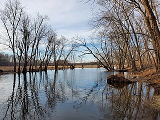
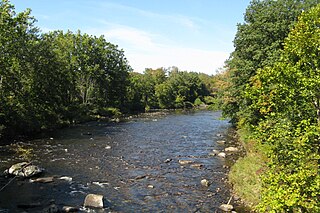
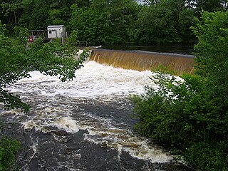
The Coginchaug River in Connecticut, with a watershed including 39 sq mi of forests, pastures, farmland, industrial, and commercial areas, is the main tributary of the Mattabesset River. It is 16.1 mi long, and the river flows northwards from a point approximately 1.8 mi south of the Durham line in Guilford, Connecticut, into Durham and then Middlefield, meeting the Mattabesset in Middletown, about 0.8 miles (1.3 km) upstream of the Connecticut River. The name "Coginchaug" comes from a local Native American name for the Durham area and it was the original name for the town. It has been said to mean "The Great Swamp", and is a reference to the meadows found in the central part of town.
Cockaponset State Forest is the second largest forest in the Connecticut state forest system, encompassing over 17,000 acres (6,900 ha) of land. Most of the land is in Middlesex County though some parcels lie in New Haven County. The forest is disjointed, and comprises land in the towns of Haddam, Chester, Deep River, Killingworth, Durham, Guilford, Madison, Clinton, Westbrook, Middletown and Middlefield.
McIndoes Reservoir is a 545-acre (2.21 km2) impoundment on the Connecticut River on the boundary between Vermont and New Hampshire in northern New England. The dam forming the reservoir lies between the communities of McIndoe Falls, Vermont, and Monroe, New Hampshire. Monroe Road crosses the reservoir 600 feet (180 m) north (upstream) of the dam, leading west 0.2 miles (0.3 km) to U.S. Route 5 in McIndoe Falls and east the same distance to New Hampshire Route 135 in the center of Monroe. The next river crossing upstream is a bridge carrying the North Monroe Road, 1.5 miles (2.4 km) north of McIndoe Falls.

The Naugatuck River is a 40.2-mile-long (64.7 km) river in the U.S. state of Connecticut. Its waters carve out the Naugatuck River Valley in the western reaches of the state, flowing generally due south and eventually emptying into the Housatonic River at Derby, Connecticut and thence 11 miles (18 km) to Long Island Sound. The Plume and Atwood Dam in Thomaston, completed in 1960 following the Great Flood of 1955, creates a reservoir on the river and is the last barrier to salmon and trout migrating up from the sea.

The Ware River is a 35.4-mile-long (57.0 km) river in central Massachusetts. It has two forks, its West Branch, which begins in Hubbardston, Massachusetts, and its East Branch, which begins in Westminster, Massachusetts. The Ware River flows southwest through the middle of the state, joins the Quaboag River at Three Rivers, Massachusetts, to form the Chicopee River on its way to the Connecticut River.

The Starr Mill Road Bridge is a historic bridge in Middletown, Connecticut. It is a single span Warren through truss bridge, spanning the Coginchaug River near the Starr Mill complex on the west bank of the river. Built in 1927 by the Berlin Construction Company, it is one of a shrinking number of period metal truss bridges in the state. The bridge was listed on the National Register of Historic Places in 1993. It is closed to all forms of passage.
The Westfield River is a major tributary of the Connecticut River located in the Berkshires and Pioneer Valley regions of western Massachusetts. With four major tributary branches that converge west of the city of Westfield, it flows 78.1 miles (125.7 km) before its confluence with the Connecticut River at Agawam, across from the city of Springfield's Metro Center district. Known for its whitewater rapids and scenery, the Westfield River provides over 50 miles (80 km) of whitewater canoeing and kayaking, in addition to one of the largest roadless wilderness areas remaining in the Commonwealth.

The Millers River is a 52.1-mile-long (83.8 km) river in northern Massachusetts, originating in Ashburnham and joining the Connecticut River just downstream from Millers Falls, Massachusetts. Sections of the river are used for whitewater kayaking, and a section upriver is popular with flatwater racers, and the river is known locally as a good place for pike fishing.
The Quinebaug River is a river in south-central Massachusetts and eastern Connecticut, with watershed extending into western Rhode Island. The name "Quinebaug" comes from the southern New England Native American term, spelled variously Qunnubbâgge, Quinibauge, etc., meaning "long pond", from qunni-, "long", and -paug, "pond". The river is one of the namesake rivers in the Quinebaug and Shetucket Rivers Valley National Heritage Corridor.

Mansfield Hollow Lake is a reservoir resting on the border of Windham County and Tolland County, Connecticut. The reservoir provides drinking water for Willimantic and helps control flooding in the 159-square-mile Thames River watershed. It was created by the Mansfield Hollow Dam and is entirely contained within Mansfield Hollow State Park and the Mansfield Hollow Wildlife Area. Designed and constructed by the United States Army Corps of Engineers, the dam substantially reduces flooding along the Quinebaug, Shetucket, and Thames rivers. Construction of the project began in 1949 with completion in 1952 at a cost of US$6.5 million. The Mansfield Hollow reservoir is located within the Shetucket River Watershed and is part of the Thames River Basin. Access to the site is available from US Route 6 and State Route 195. The damsite, covering an area of 25 acres (10 ha), was listed on the National Register of Historic Places in 2003.
Hop Brook Lake is spread over three communities in New Haven County, Connecticut, United States. These communities are Naugatuck, Middlebury, and Waterbury. A dam was created across Hop Brook in Naugatuck and the lake that was created is known as Hop Brook Lake.

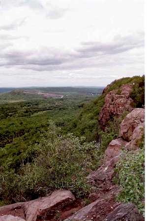
Besek Mountain also known as Black Mountain, est. 840 feet (260 m), is a traprock mountain ridge located 4.75 miles (7.6 km) southeast of Meriden, Connecticut. It is part of the narrow, linear Metacomet Ridge that extends from Long Island Sound near New Haven, Connecticut, north through the Connecticut River Valley of Massachusetts to the Vermont border. Besek Mountain is known for its 3-mile (4.8 km) long line of open cliffs, unique microclimate ecosystems, and rare plant communities. The mountain is traversed by the 51-mile (82 km) Mattabesett Trail, and is home to the Powder Ridge Ski Area.

Powder Ridge Ski Area is a ski area located in Middlefield, Connecticut. It began operations on January 22, 1961, closed in 2007, and reopened in 2013 as Powder Ridge Mountain Park & Resort. It is located on Besek Mountain. Powder Ridge Park is affiliated with the Brownstone Exploration and Discovery Park in the Portland Brownstone Quarries in nearby Portland, Connecticut.

Route 147 is a state highway in central Connecticut running from Durham to Middlefield.

Lake Sunapee is located within Sullivan County and Merrimack County in western New Hampshire, the United States. It is the fifth-largest lake located entirely in New Hampshire.
Hidden Lake is one of five villages located within the town of Haddam, Connecticut. It is governed by the bylaws of the Hidden Lake Association.

Lake Zoar is a reservoir on the Housatonic River in the U.S. state of Connecticut. It was formed by the completion of the Stevenson Dam, which flooded an area of Oxford and Stevenson named "Pleasantvale" or "Pleasant Vale". "Connecticut's Lakes Reflect Our History, Present". Retrieved 2018-04-02. The towns of Monroe, Newtown, Oxford, and Southbury border Lake Zoar. The name Zoar originates from corner of Newtown and Monroe that once called itself Zoar after the Biblical city Zoara near the Dead Sea.