Charlestown, New Hampshire

Last updated

Charlestown, New Hampshire
Main Street, Charlestown, NH.jpg
Main Street in 1910
Charlestown Town Seal.png
Sullivan County New Hampshire incorporated and unincorporated areas Charlestown highlighted.svg
Location in Sullivan County and the state of New Hampshire
Coordinates: 43°14′04″N72°25′28″W / 43.23444°N 72.42444°W / 43.23444; -72.42444
CountryUnited States
State New Hampshire
County Sullivan
Incorporated 1783
Villages
  • Charlestown
  • Hemlock Center
  • North Charlestown
  • Snumshire
  • South Charlestown
  • South Hemlock
Government
   Selectboard
  • Jeremy Wood, Chair
  • Nancy Houghton
  • Trish Beaudry
  • Shelly Blouin-Andrus
  • William Rescsanski
Area
[1]
  Total38.0 sq mi (98.5 km2)
  Land35.8 sq mi (92.6 km2)
  Water2.3 sq mi (5.9 km2)  5.98%
Elevation
384 ft (117 m)
Population
 (2020)
  Total4,806
  Density134/sq mi (51.9/km2)
Time zone UTC-5 (Eastern)
  Summer (DST) UTC-4 (Eastern)
ZIP code
03603
Area code 603
FIPS code 33-11380
GNIS feature ID0873562
Website www.charlestown-nh.gov

Charlestown is a town in Sullivan County, New Hampshire, United States. The population was 4,806 at the 2020 census, [2] down from 5,114 at the 2010 census. The town is home to Hubbard State Forest and the headquarters of the Student Conservation Association.

Contents

The primary village in town, where 1,078 people resided at the 2020 census, [3] is defined as the Charlestown census-designated place (CDP) and is located along New Hampshire Route 12. The town also includes the villages of North Charlestown, South Charlestown and Hemlock Center. [4]

History

The area was first granted on December 31, 1735, [5] by colonial governor Jonathan Belcher of Massachusetts as "Plantation No. 4", the fourth in a line of townships on the Connecticut Rivers. [lower-alpha 1] Settled in 1740, it was the northernmost township, and its 1744 stockade now known as Fort at Number 4 became a strategic military site. On the evening of May 2, 1746, Seth Putnam joined Major Josiah Willard and several soldiers as they escorted women to milk the cows. As they approached the barn, Natives hiding in the bushes opened fire, killing Putnam, "the first victim of [Native] vengeance". [7] :26–27 In 1747, during King George's War, the fort was besieged for three days by a force of French and Native people. Captain Phineas Stevens and 31 militia stationed at the fort repelled the attack, with their success becoming well-known. [7] :33–38

On July 2, 1753, [5] the town was rechartered as "Charlestown" by Governor Benning Wentworth, after Admiral Charles Knowles of the Royal Navy, then governor of Jamaica. Admiral Knowles, in port at Boston during the 1747 siege, sent Captain Stevens a sword to acknowledge his valor. The town responded by naming itself in his honor.

Early in the morning of August 30, 1754, Susannah Willard Johnson along with her husband, her three children, her sister and two neighbors, Peter Labarree and Ebenezer Farnsworth, were captured by Abenaki people, marched to Montreal and incarcerated. Eventually they would all escape or be released and return home.

In 1781, Charlestown briefly joined Vermont because of dissatisfaction with treatment by the New Hampshire government. Returning at the insistence of George Washington, it was incorporated in 1783. [8]

The community developed into a center for law and lawyers, second regionally only to Boston. Its prosperity would be expressed in fine architecture. Sixty-three buildings on Charlestown's Main Street are now listed on the National Register of Historic Places. They include the Gothic Revival South Parish Church erected by master-builder Stephen Hassam in 1842, St. Luke's Church designed by Richard Upjohn in 1863, and the Italianate Town Hall designed in 1872 by Edward Dow, New Hampshire's most prominent architect after the Civil War. Dow also designed Thompson Hall, the centerpiece of the University of New Hampshire.

In 1874, the Sullivan Railroad passed through the western side of Charlestown. [5] The tracks are now part of the New England Central Railroad.

A reproduction of the Fort at Number 4 is now a historical site, where military reenactments and musters occur frequently throughout the summer months. Tours are offered of its stockaded parade ground and pioneer-style houses.

Geography

Charlestown is located along the Connecticut River, the western border of New Hampshire.

According to the United States Census Bureau, the town has a total area of 38.0 square miles (98.5 km2), of which 35.8 sq mi (92.6 km2) are land and 2.3 sq mi (5.9 km2) are water, comprising 5.98% of the town. [1] Charlestown is drained by several direct tributaries of the Connecticut River: [9] Ox Brook, the Little Sugar River, Beaver Brook, Clay Brook, Dickerson Brook, and Jabes Meadow Brook. The highest point in town is Sams Hill, at 1,683 feet (513 m) above sea level in the southeast part of town.

In the Connecticut River in the 1800s were three islands within the limits of the town. Sartwell's Island, the largest, containing 10 acres (4.0 ha), was under high cultivation in 1874. The others contained about 6 acres (2.4 ha) each. [5] None show on maps today, and were presumably inundated by the power dam built downstream at Bellows Falls.

Adjacent municipalities

Transportation

Charlestown is served by New Hampshire Routes 11, 12 and 12A. Routes 11 and 12 lead north from the town center 11 miles (18 km) to downtown Claremont. Route 12 leads south 7 miles (11 km) to North Walpole, adjacent to Bellows Falls, Vermont, and 28 miles (45 km) to Keene, New Hampshire. Route 11 leads northwest from the center of Charlestown to the Cheshire Bridge (the old toll bridge) across the Connecticut River, after which it becomes Vermont Route 11 and provides access to Interstate 91 and U.S. Route 5 in Vermont.

Bus service is available from Community Alliance Transport Services (CATS), with several buses a day connecting Charlestown and Claremont. [10]

The New England Central Railroad has track rights through the town. Amtrak's Vermonter passenger rail line runs through Charlestown along the Connecticut River but does not stop in town. The closest stations are Bellows Falls to the south and Claremont to the north.

The nearest general aviation airports are Claremont Municipal Airport, 10 miles (16 km) to the north, and Hartness State Airport in North Springfield, Vermont, 11 miles (18 km) to the northwest. The nearest airport with scheduled airline service is Lebanon Municipal Airport, 33 miles (53 km) to the north in West Lebanon.

Public safety

Charlestown is served by a full-time police department and volunteer fire department. Charlestown's ambulance service is provided by Golden Cross Ambulance out of Claremont. The town's emergency services are dispatched by the Charlestown Police Department dispatch center and headed by Chief Patrick Connors.

Charlestown falls within Troop C of the New Hampshire State Police.

Demographics

Historical population
CensusPop.Note
1790 1,093
1800 1,36424.8%
1810 1,50110.0%
1820 1,70213.4%
1830 1,7734.2%
1840 1,722−2.9%
1850 1,644−4.5%
1860 1,7586.9%
1870 1,741−1.0%
1880 1,587−8.8%
1890 1,466−7.6%
1900 1,4730.5%
1910 1,4961.6%
1920 1,5050.6%
1930 1,6449.2%
1940 1,7566.8%
1950 2,07718.3%
1960 2,57624.0%
1970 3,27427.1%
1980 4,41734.9%
1990 4,6304.8%
2000 4,7492.6%
2010 5,1147.7%
2020 4,806−6.0%
U.S. Decennial Census [11] [ failed verification ] 2020 [2]

As of the census of 2010, there were 5,114 people, 2,117 households, and 1,399 families residing in the town. There were 2,263 housing units, of which 146, or 6.5%, were vacant. The racial makeup of the town was 97.8% white, 0.4% African American, 0.2% Native American, 0.4% Asian, 0.0% Native Hawaiian or Pacific Islander, 0.1% some other race, and 1.0% from two or more races. 0.8% of the population were Hispanic or Latino of any race. [12]

Of the 2,117 households, 28.8% had children under the age of 18 living with them, 50.4% were headed by married couples living together, 10.0% had a female householder with no husband present, and 33.9% were non-families. 27.4% of all households were made up of individuals, and 11.3% were someone living alone who was 65 years of age or older. The average household size was 2.38, and the average family size was 2.84. [12]

In the town, 20.7% of the population were under the age of 18, 7.7% were from 18 to 24, 23.3% from 25 to 44, 32.4% from 45 to 64, and 16.2% were 65 years of age or older. The median age was 43.9 years. For every 100 females, there were 97.2 males. For every 100 females age 18 and over, there were 94.4 males. [12]

For the period 2011–2015, the estimated median annual income for a household was $41,471, and the median income for a family was $52,708. The per capita income for the town was $23,527. 13.2% of the population and 9.5% of families were below the poverty line. 16.0% of the population under the age of 18 and 9.1% of those 65 or older were living in poverty. [13]

Sites of interest

Notable people

Old stage coach in 1907, plying between Charlestown and Springfield, Vermont Stage Coach Between Charlestown, NH and Springfield, VT.jpg
Old stage coach in 1907, plying between Charlestown and Springfield, Vermont

Notes

  1. Number 1 was in Chesterfield, Number 2 was in Westmoreland, and Number 3 was in Walpole. [6]

Related Research Articles

<span class="mw-page-title-main">Sullivan County, New Hampshire</span> County in New Hampshire, United States

Sullivan County is a county in the U.S. state of New Hampshire. As of the 2020 census, the population was 43,063, making it the second-least populous county in New Hampshire. Its county seat is Newport.

<span class="mw-page-title-main">Walpole, New Hampshire</span> Town in New Hampshire, United States

Walpole is a town in Cheshire County, New Hampshire, United States. The population was 3,633 at the 2020 census.

<span class="mw-page-title-main">Westmoreland, New Hampshire</span> Town in New Hampshire, United States

Westmoreland is a town in Cheshire County, New Hampshire, United States. The population was 1,706 at the 2020 census, down from 1,874 at the 2010 census. Westmoreland is historically an agricultural town, with much arable farmland.

<span class="mw-page-title-main">Piermont, New Hampshire</span> Town in New Hampshire, United States

Piermont is a town in Grafton County, New Hampshire, United States. The population was 769 at the 2020 census. It is home to Camp Walt Whitman and Kingswood Camp for Boys.

<span class="mw-page-title-main">Acworth, New Hampshire</span> Town in New Hampshire, United States

Acworth is a town in Sullivan County, New Hampshire, United States. At the 2020 census, the town had a total population of 853.

<span class="mw-page-title-main">Claremont, New Hampshire</span> City in New Hampshire, United States

Claremont is the only city in Sullivan County, New Hampshire, United States. The population was 12,949 at the 2020 census.

<span class="mw-page-title-main">Cornish, New Hampshire</span> Town in New Hampshire, United States

Cornish is a town in Sullivan County, New Hampshire, United States. The population was 1,616 at the 2020 census. Cornish has four covered bridges. Each August, it is home to the Cornish Fair.

<span class="mw-page-title-main">Lempster, New Hampshire</span> Place in New Hampshire, United States

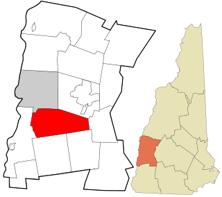
Lempster is a town in Sullivan County, New Hampshire, United States. The population was 1,118 at the 2020 census. Settlements include the town center and the village of East Lempster.

<span class="mw-page-title-main">Plainfield, New Hampshire</span> Place in New Hampshire, United States

Plainfield is a town in Sullivan County, New Hampshire, United States. At the time of the 2020 census, the town had a population of 2,459. The town is home to the Helen Woodruff Smith Bird Sanctuary and Annie Duncan State Forest.

<span class="mw-page-title-main">Unity, New Hampshire</span> Place in New Hampshire, United States

Unity is a town in Sullivan County, New Hampshire, United States. The population was 1,518 at the 2020 census, down from 1,671 at the 2010 census. The town includes the villages of Unity, East Unity, Quaker City, and West Unity.

<span class="mw-page-title-main">Guildhall, Vermont</span> Town in Vermont, United States

Guildhall is a town in and the shire town of Essex County, Vermont. As of the 2020 census, the population was 262. According to a large sign in the town center, it is the only town in the world so named. The name derives from a meeting house on the square called the Guildhall.

<span class="mw-page-title-main">Lunenburg, Vermont</span> Town in Vermont, United States

Lunenburg is a town in Essex County, Vermont, United States. The population was 1,246 at the 2020 census, the most populous in Essex County. Lunenburg contains the villages of Lunenburg and Gilman and hamlets of West Lunenburg, South Lunenburg, and Mill Village, and is part of the Berlin, NH–VT Micropolitan Statistical Area.

<span class="mw-page-title-main">Putney, Vermont</span> Town in Vermont, United States

Putney is a town in Windham County, Vermont, United States. The population was 2,617 at the 2020 census.

<span class="mw-page-title-main">Rockingham, Vermont</span> Town in Vermont, United States

Rockingham is a town along the Connecticut River in Windham County, Vermont, United States. As of the 2020 census, the population was 4,832. Rockingham includes the incorporated villages of Bellows Falls and Saxtons River, as well as a large rural area west of Interstate 91.

<span class="mw-page-title-main">Charlestown (CDP), New Hampshire</span> Census-designated place in New Hampshire, United States

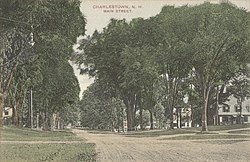
Charlestown is a census-designated place (CDP) and the main village in the town of Charlestown, Sullivan County, New Hampshire, United States. The population of the CDP was 1,078 at the 2020 census, out of 4,806 in the entire town.

<span class="mw-page-title-main">Newport, New Hampshire</span> Place in New Hampshire, United States

Newport is a town in and the county seat of Sullivan County, New Hampshire, United States. It is 43 miles (69 km) west-northwest of Concord, the state capital. The population of Newport was 6,299 at the 2020 census. A covered bridge is in the northwest. The area is noted for maple sugar and apple orchards. Prior to county division in 1827, Newport was in Cheshire County. The central part of town, where 4,735 people resided at the 2020 census, is defined as the Newport census-designated place (CDP) and is located next to the Sugar River at the junction of New Hampshire routes 10 and 11. The town also includes the villages of Kelleyville, Guild, and North Newport.

<span class="mw-page-title-main">New Hampshire Route 12</span> State highway in southwestern New Hampshire, US

New Hampshire Route 12 is a 62.773-mile (101.023 km) long north-south state highway in southwestern New Hampshire. Its southern terminus is at the Massachusetts state line in Fitzwilliam, where it continues south as Massachusetts Route 12. Its northern terminus is at the Vermont state line in Claremont, where it continues north as Vermont Route 12. Most of the northern part of NH 12 runs along the Connecticut River.

<span class="mw-page-title-main">Fort at Number 4</span> Historic fort in New Hampshire

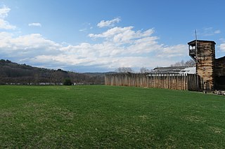
The Fort at Number 4 was a mid-18th century stockade fortification protecting Plantation Number 4, the northernmost British settlement along the Connecticut River in the Province of New Hampshire until after the French and Indian War. It was located in the present-day town of Charlestown, New Hampshire. A recreation of the fort, dating to 1960, now functions as an open-air museum, and was added to the New Hampshire State Register of Historic Places in July 2020.

<span class="mw-page-title-main">North Walpole, New Hampshire</span> Census-designated place in New Hampshire, United States

North Walpole is a census-designated place (CDP) in the town of Walpole in Cheshire County, New Hampshire, United States. It had a population of 785 at the 2020 census, making it the largest village in the town of Walpole.

<span class="mw-page-title-main">Walpole (CDP), New Hampshire</span> Census-designated place in New Hampshire, United States

Walpole is a census-designated place (CDP) and the central village in the town of Walpole in Cheshire County, New Hampshire, United States. The population of the CDP was 573 at the 2020 census, compared to 3,633 in the entire town.

References

  1. 1 2 "2021 U.S. Gazetteer Files – New Hampshire". United States Census Bureau. Retrieved January 6, 2022.
  2. 1 2 "Census - Geography Profile: Charlestown town, Sullivan County, New Hampshire". United States Census Bureau . Retrieved December 24, 2021.
  3. "Census - Geography Profile: Charlestown CDP, New Hampshire". United States Census Bureau . Retrieved December 24, 2021.
  4. "Charlestown, NH". Economic & Labor Market Information Bureau of New Hampshire. Archived from the original on July 26, 2009. Retrieved May 22, 2009.
  5. 1 2 3 4 Article in Statistics and Gazetteer of New-Hampshire (1875)
  6. "Fort at Number 4". Brattleboro Reformer . Brattleboro, Vermont. May 7, 1960. p. 4. Retrieved December 5, 2020 via newspapers.com.
  7. 1 2 Saunderson, Henry H. (1876). History of Charlestown, New Hampshire. Claremont, New Hampshire: The Claremont Manufacturing Company via Wayback Machine. From its settlement to 1876
  8. Coolidge, Austin J.; John B. Mansfield (1859). A History and Description of New England. Boston, Massachusetts: A.J. Coolidge. pp.  438–441.
  9. Foster, Debra H.; Batorfalvy, Tatianna N.; Medalie, Laura (1995). Water Use in New Hampshire: An Activities Guide for Teachers. U.S. Department of the Interior and U.S. Geological Survey.
  10. "Bus Stops, Fares & Transfers". Community Alliance of Human Services. Archived from the original on November 11, 2013. Retrieved December 19, 2013.
  11. "Census of Population and Housing". Census.gov. Retrieved June 4, 2016.
  12. 1 2 3 "Profile of General Population and Housing Characteristics: 2010 Census Summary File 1 (DP-1): Charlestown town, Sullivan County, New Hampshire". American Factfinder. U.S. Census Bureau. Archived from the original on February 13, 2020. Retrieved November 13, 2017.
  13. "Selected Economic Characteristics: 2011-2015 American Community Survey 5-Year Estimates (DP03): Charlestown town, Sullivan County, New Hampshire". American Factfinder. U.S. Census Bureau. Archived from the original on February 13, 2020. Retrieved November 13, 2017.
  14. "James Broderick". The Internet Movie Database. Retrieved December 7, 2009.
  15. "Beginnings of the Cascade Paper Mill" (PDF). Archived from the original (PDF) on April 21, 2012. Retrieved December 30, 2011.
  16. Minnesota Legislators: Past & Present-George Brintnall Dutton
  17. "Biography". Carltonfisk.com. Retrieved December 7, 2009.
  18. Roberts, Gary Boyd, and David Curtis Dearborn (1998). Notable Kin: An Anthology of Columns First Published in the NEHGS Nexus, 1986–1995. Boston, Massachusetts: New England Historic Genealogical Society. p. 107. ISBN   978-0-936124-20-9.{{cite book}}: CS1 maint: multiple names: authors list (link)
  19. Van Dulken, Stephen (2001). Inventing the 19th century: 100 inventions that shaped the Victorian Age from Aspirin to the Zeppelin. New York City: New York University Press. p. 28. ISBN   978-0-8147-8810-3.
  20. Hoyt, Cliff and Linda (March 2, 2009). "Charles Hoyt, Popular Playwright of the Gay Nineties". The Advertising Collections of Cliff & Linda Hoyt. Archived from the original on January 27, 2010. Retrieved December 7, 2009.
  21. "Hubbard, Henry, (1784–1857)". Biographical Directory of the United States Congress. Retrieved December 7, 2009.
  22. "Hunt, Samuel, (1765–1807)". Biographical Directory of the United States Congress. Retrieved December 7, 2009.
  23. Bastedo, Russell. "A Guide to Likenesses of New Hampshire Officials and Governors on Public Display at the Legislative Office Building and the State House Concord, New Hampshire, to 1998". New Hampshire Division of Historical Records. Retrieved December 7, 2009.
  24. "Olcott, Simeon, (1735–1815)". Biographical Directory of the United States Congress. Retrieved December 7, 2009.
  25. "Wyoming Governor De Forest Richards". Governor's Information. National Governors Association. Retrieved December 7, 2009.
  26. "Catalogue of Officers and Students of Middlebury College in Middlebury, Vermont," 1901, pg. 146
  27. 'The Bench and Bar of New Hampshire,' Charles H. Bell-editor, Houghtom Mifflin and Company-Riverside Press, Cambridge, Massachusetts: 1894, Biographical of Benjamin West, pg. 727-729
  28. Gass, Patrick, and James Kendall Hosmer (1904). Gass's Journal of the Lewis and Clark Expedition. A. C. McClurg & Co. p. xxi.{{cite book}}: CS1 maint: multiple names: authors list (link)
  29. Clarke, Charles G., and Dayton Duncan (2002). The Men of the Lewis and Clark Expedition. Lincoln, Nebraska: University of Nebraska Press. p. xii. ISBN   978-0-8032-6419-9.{{cite book}}: CS1 maint: multiple names: authors list (link)