Sullivan County is a county in the U.S. state of New Hampshire. As of the 2010 census, the population was 43,742, making it the second-least populous county in New Hampshire. Its county seat is Newport.

Nelson is a town in Cheshire County, New Hampshire, United States. The population was 729 at the 2010 census. Nelson includes the village of Munsonville.
Danbury is a town in Merrimack County, New Hampshire, United States. The population was 1,164 at the 2010 census.

New London is a town in Merrimack County, New Hampshire, United States. The population was 4,397 at the 2010 census. The town is the home of Colby–Sawyer College.

Newbury is a town in Merrimack County, New Hampshire, United States. The population was 2,072 at the 2010 census. Newbury is home to part of Lake Sunapee, including Mount Sunapee State Park Beach. Mount Sunapee Resort, a ski area in Mount Sunapee State Park, is in the west. The town includes the villages of Blodgett Landing and South Newbury.

Sutton is a town in Merrimack County, New Hampshire, United States. The population was 1,837 at the 2010 census. Sutton includes the villages of Sutton Mills, North Sutton, South Sutton and East Sutton. North Sutton is home to Wadleigh State Park on Kezar Lake.

Warner is a town in Merrimack County, New Hampshire, United States. The population was 2,833 at the 2010 census. The town is home to Magdalen College of the Liberal Arts, Rollins State Park and Mount Kearsarge State Forest.

Wilmot is a town in Merrimack County, New Hampshire, United States. The population was 1,358 at the 2010 census. The town includes the villages of Wilmot, Wilmot Flat, and North Wilmot.
Goshen is a town in Sullivan County, New Hampshire, United States. The population was 810 at the 2010 census.
Springfield is a town in Sullivan County, New Hampshire, United States. The population was 1,311 at the 2010 census. Gile State Forest is located within the town.

Sunapee is a town in Sullivan County, New Hampshire, United States. The population was 3,365 at the 2010 census. Sunapee is home to part of Lake Sunapee. The town includes the village of Georges Mills.

Newport is a census-designated place (CDP) comprising the primary village and surrounding rural land in the town of Newport in Sullivan County, New Hampshire, United States. The population of the CDP was 4,769 at the 2010 census, out of 6,507 people in the entire town of Newport.

Newport is a town in and the county seat of Sullivan County, New Hampshire, United States. It is 43 miles (69 km) west-northwest of Concord. The population was 6,507 at the 2010 census. A covered bridge is in the northwest. The area is noted for maple sugar and apple orchards. Prior to county division in 1827, Newport was in Cheshire County.

New Hampshire Route 114 is a 60.433-mile-long (97.257 km) secondary north–south highway in central New Hampshire. The highway runs between Bedford in Hillsborough County and Grantham in Sullivan County.

New Hampshire Route 11 is a 108.223-mile-long (174.168 km) east–west state highway in New Hampshire, running completely across the central part of the state. Its western terminus is at the Vermont state line in Charlestown, where it continues west as Vermont Route 11. The eastern terminus is at the Maine state line in Rochester, where it crosses the border with U.S. Route 202 and continues as Maine State Route 11.

New Hampshire Route 103 is a 48.300-mile-long (77.731 km) east–west highway in west-central New Hampshire, United States. The highway runs from Claremont, at the Vermont border on the Connecticut River, to Hopkinton, west of Concord.
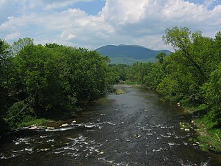
The Sugar River is a 27.0-mile-long (43.5 km) river located in western New Hampshire in the United States. It is a tributary of the Connecticut River, which flows to Long Island Sound.

Mount Sunapee is a 5-mile-long (8.0 km) mountain ridge in the towns of Newbury and Goshen in western New Hampshire, United States. Its highest peak, at the north end of the mountain, is 2,726 feet (831 m) above sea level. The mountain has three secondary peaks, White Ledges at 2,716 ft (828 m); North Peak at 2,280 ft (695 m); and South Peak at 2,608 ft (795 m). The north end of the mountain, including the summit, is within Mount Sunapee State Park, which encompasses 3.85 square miles (10.0 km2) and is home to the popular Mount Sunapee Resort. The mountain extends south to Pillsbury State Park in the towns of Goshen and Washington.

Lake Solitude is a highland tarn located in western New Hampshire, United States, at the top of Sunapee Ridge between the main summit of Mount Sunapee and South Peak. The lake, covering 6 acres (2.4 ha), is approximately 832 feet (254 m) long by 383 feet (117 m) wide and is located within Mount Sunapee State Park in the town of Newbury. A popular hiking destination, Lake Solitude is accessible via the Andrew Brook Trail, the Newbury Trail, or the long-distance Monadnock-Sunapee Greenway Trail. White Ledge, elevation 2,720 feet (830 m), rises steeply above the lake's west shore and provides expansive views. The lake is considered an important habitat for rare species and is off limits to swimmers and dogs.

Lake Sunapee is located within Sullivan County and Merrimack County in western New Hampshire, the United States. It is the fifth-largest lake located entirely in New Hampshire.


