Crystal Lake, Connecticut

Last updated

Crystal Lake
Sandy Beach, Crystal Lake, Ellington Connecticut USA.JPG
Ellington's town beach, Sandy Beach
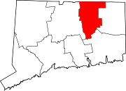
Tolland County Connecticut Incorporated and Unincorporated areas Crystal Lake Highlighted 2010.svg
Location in Tolland County and the state of Connecticut
Coordinates: 41°56′41″N72°22′24″W / 41.9448°N 72.3734°W / 41.9448; -72.3734
CountryUnited States
State Connecticut
County Tolland
Town Ellington
Area
  Total8.1 sq mi (21 km2)
  Land7.8 sq mi (20 km2)
  Water0.3 sq mi (0.8 km2)
Elevation
636 ft (194 m)
Population
 (2010)
  Total1,945
  Density240/sq mi (93/km2)
Time zone UTC−5 (Eastern (EST))
  Summer (DST) UTC−4 (EDT)
ZIP code
06029
Area code860
FIPS code09-18220
GNIS feature ID2377812 [1]

Crystal Lake is a village, [2] census-designated place, and part of the town of Ellington, in Tolland County, Connecticut, United States. The population was 1,945 at the 2010 census. The CDP includes an eponymous lake. [3]

Contents

Geography

The CDP is home to Crystal Lake, a 187-acre (76 ha) lake that straddles the border between Ellington and Stafford. [4] Most of the lake shore is occupied by private residences, but there is a small public beach called Sandy Beach on the southern side of the lake. The lake has an average depth of 20 feet (6.1 m), a maximum depth of 50 feet (15 m) [5] and an elevation of 637 feet (194 m). [1]

According to the United States Census Bureau, the CDP has a total area of 20.9 km2 (8.1 mi2), of which 20.2 km2 (7.8 mi2) is land and 0.7 km2 (0.3 mi2) (3.35%) is water.

Demographics

As of the census [6] of 2000, there were 1,459 people, 552 households, and 421 families residing in the CDP. The population density was 72.2/km2 (187.1/mi2). There were 634 housing units at an average density of 31.4/km2 (81.3/mi2). The racial makeup of the CDP was 97.67% White, 0.41% African American, 0.07% Native American, 0.82% Asian, 0.21% from other races, and 0.82% from two or more races. Hispanic or Latino of any race were 1.03% of the population.

There were 552 households, out of which 36.1% had children under the age of 18 living with them, 64.3% were married couples living together, 7.6% had a female householder with no husband present, and 23.7% were non-families. 17.2% of all households were made up of individuals, and 5.3% had someone living alone who was 65 years of age or older. The average household size was 2.64 and the average family size was 3.00.

In the CDP, the population was spread out, with 26.3% under the age of 18, 4.0% from 18 to 24, 34.3% from 25 to 44, 25.7% from 45 to 64, and 9.7% who were 65 years of age or older. The median age was 38 years. For every 100 females, there were 100.4 males. For every 100 females age 18 and over, there were 100.6 males.

The median income for a household in the CDP was $61,897, and the median income for a family was $69,375. Males had a median income of $46,393 versus $36,944 for females. The per capita income for the CDP was $24,645. About 5.6% of families and 7.9% of the population were below the poverty line, including 13.2% of those under age 18 and 2.8% of those age 65 or over.

Related Research Articles

<span class="mw-page-title-main">Oakville, Connecticut</span> Census-designated place in Connecticut, United States

Oakville is a census-designated place (CDP) and neighborhood section of Watertown, in Litchfield County, Connecticut, United States. The population was 9,047 as of the 2010 census. It is the most populous community in Watertown, with more than twice as many people as the center village of Watertown. The ZIP code for Oakville is 06779.

<span class="mw-page-title-main">Conning Towers Nautilus Park, Connecticut</span> Census-designated place in Connecticut, United States

Conning Towers Nautilus Park is a census-designated place (CDP) in the town of Groton in New London County, Connecticut, United States. The population was 9,828 at the 2010 census. The statistical area consists of the portion of the town in the vicinity of Route 12 and includes Naval Submarine Base New London.

<span class="mw-page-title-main">Oxoboxo River, Connecticut</span> Census-designated place in Connecticut, United States

Oxoboxo River is a census-designated place (CDP) in the town of Montville in New London County, Connecticut, United States. The population was 2,938 at the 2000 census, 3,165 at the 2010 census, and 2,955 at the 2020 census. The statistical area encompasses the town center of Montville, as well as the adjacent villages of Palmertown and Uncasville. The name of the statistical area is from the river of the same name running through the CDP.
<span class="mw-page-title-main">Coventry Lake, Connecticut</span> Census-designated place in Connecticut, United States

Coventry Lake is a village and census-designated place in the town of Coventry in Tolland County, Connecticut, United States. The population was 2,990 at the 2010 census. The CDP includes the residential areas around Wangumbaug Lake.

<span class="mw-page-title-main">Mansfield Center, Connecticut</span> CDP in Connecticut, United States

Mansfield Center is a village within the town of Mansfield in Tolland County, Connecticut, United States. The village is the basis of a census-designated place (CDP) of the same name with a population of 947 at the 2010 census. The CDP includes the original settlement of Mansfield, Mansfield Center or Mansfield Village, as well as the village of Mansfield Hollow. Mansfield Hollow State Park is also located within the boundaries of the CDP.

<span class="mw-page-title-main">South Coventry (CDP), Connecticut</span> CDP in Connecticut, United States

South Coventry is a census-designated place and part of the town of Coventry in Tolland County, Connecticut, United States. The population was 1,483 at the 2010 census.

<span class="mw-page-title-main">East Brooklyn, Connecticut</span> Census-designated place in Connecticut, United States

East Brooklyn is a census-designated place (CDP) located within the town of Brooklyn in Windham County, Connecticut. It is the portion of the Danielson urban cluster within the town of Brooklyn. The population was 2,205 at the 2020 census. US 6 runs through the town and severs the town.

<span class="mw-page-title-main">Quinebaug, Connecticut</span> Census-designated place in Connecticut, United States

Quinebaug is a village and census-designated place (CDP) in Thompson, a town in Windham County, Connecticut, United States. The population was 1,133 at the 2010 census.

<span class="mw-page-title-main">South Windham, Connecticut</span> Village in Connecticut, United States

South Windham is a village and census-designated place (CDP) in Windham County, Connecticut, United States. It is located within the town of Windham, Connecticut. The population was 1,421 at the 2010 census.

<span class="mw-page-title-main">Placid Lakes, Florida</span> Unincorporated community in Florida, United States

Placid Lakes is an unincorporated community in Highlands County, Florida, United States. The population was 3,054 according to the 2000 census, at which time it was a census-designated place (CDP). Placid Lakes is a predominantly residential community southwest of the town of Lake Placid and due south of Lake June.

<span class="mw-page-title-main">Holden Heights, Florida</span> Census-designated place in Florida, United States

Holden Lakes is a census-designated place and unincorporated area in Orange County, Florida, United States. The population was 3,679 at the 2010 census. The ZIP code serving the CDP is 32839. It is part of the Orlando–Kissimmee Metropolitan Statistical Area.

<span class="mw-page-title-main">Lake Hart, Florida</span> Census-designated place in Florida, United States

Lake Hart is a census-designated place and an unincorporated area in Orange County, Florida, United States. The population was 542 as of the 2010 census. It is part of the Orlando–Kissimmee Metropolitan Statistical Area.

<span class="mw-page-title-main">Sky Lake, Florida</span> Census-designated place in Florida, United States

Sky Lake is a census-designated place (CDP) and an unincorporated area in Orange County, Florida, United States. The population was 6,153 at the 2010 census. It is part of the Orlando-Kissimmee, Florida Metropolitan Statistical Area.

<span class="mw-page-title-main">Cypress Lakes, Florida</span> Unincorporated place in Florida, United States

Cypress Lakes was a former census-designated place (CDP) and current unincorporated place in Palm Beach County, Florida, United States. The population was 1,468 at the 2000 census.

<span class="mw-page-title-main">Fiskdale, Massachusetts</span> CDP in Sturbridge, Massachusetts, United States

Fiskdale is a census-designated place (CDP) in the town of Sturbridge in Worcester County, Massachusetts, United States. The population was 2,583 at the 2010 census.

<span class="mw-page-title-main">Crystal Lake, Polk County, Florida</span> Census-designated place in Florida, United States

Crystal Lake is a census-designated place (CDP) in Polk County, Florida, United States. The population was 5,341 at the 2000 census, an increase from 5,300 in 1990. The 2010 Census reported a population of 5,514. It is part of the Lakeland–Winter Haven Metropolitan Statistical Area.

<span class="mw-page-title-main">Brass Castle, New Jersey</span> Populated place in Warren County, New Jersey, US

Brass Castle is an unincorporated community and census-designated place (CDP) located within Washington Township, in Warren County, in the U.S. state of New Jersey. As of the 2010 United States Census, the CDP's population was 1,555.

<span class="mw-page-title-main">Wilder, Vermont</span> Census-designated place in Vermont, United States

Wilder is an unincorporated village and census-designated place (CDP) within the town of Hartford in Windsor County, Vermont, United States. It is the location of the Wilder Dam on the Connecticut River. The population of the CDP was 1,690 at the 2010 census. The village center is an early example of a planned mill community, and was listed on the National Register of Historic Places as the Wilder Village Historic District in 1999.

<span class="mw-page-title-main">Hingham (CDP), Massachusetts</span> Census-designated place in Massachusetts, United States

Hingham is a census-designated place (CDP) in the town of Hingham in Plymouth County, Massachusetts, United States. The population was 5,650 at the 2010 census.

<span class="mw-page-title-main">Brattleboro (CDP), Vermont</span> CDP in Vermont, United States

Brattleboro is a census-designated place (CDP) corresponding to the densely populated core of the town of Brattleboro in Windham County, Vermont, United States. The population was 8,289 at the 2000 census.

References

  1. 1 2 U.S. Geological Survey Geographic Names Information System: Crystal Lake
  2. Principal Communities in Connecticut, Dept. of Economic and Community Development
  3. "Crystal Lake (lake)". Geographic Names Information System . United States Geological Survey, United States Department of the Interior.
  4. "Crystal Lake, Ellington - 2013". Connecticut Agricultural Experiment Station . Retrieved November 8, 2020.
  5. "Crystal Lake". Crystal Lake Association. Retrieved November 8, 2020.
  6. "U.S. Census website". United States Census Bureau . Retrieved January 31, 2008.