North Brookfield (CDP), Massachusetts

Last updated

North Brookfield, Massachusetts
CDP
North Main Street, North Brookfield MA.jpg
North Main Street
Worcester County Massachusetts incorporated and unincorporated areas North Brookfield (CDP) highlighted.svg
Location in Worcester County and the state of Massachusetts.
Coordinates: 42°16′11″N72°5′4″W / 42.26972°N 72.08444°W / 42.26972; -72.08444
Country United States
State Massachusetts
County Worcester
Area
[1]
  Total1.48 sq mi (3.82 km2)
  Land1.48 sq mi (3.82 km2)
  Water0.00 sq mi (0.00 km2)
Elevation
873 ft (266 m)
Population
 (2020)
  Total2,256
  Density1,528.46/sq mi (590.34/km2)
Time zone UTC-5 (Eastern (EST))
  Summer (DST) UTC-4 (EDT)
ZIP code
01535
Area code 508
FIPS code 25-47100
GNIS feature ID0609951

North Brookfield is a census-designated place (CDP) in the town of North Brookfield in Worcester County, Massachusetts, United States. The population was 2,265 at the 2010 census.

Contents

Geography

According to the United States Census Bureau, the CDP has a total area of 3.8 km2 (1.5 mi2), all land. [2]

Demographics

Historical population
CensusPop.Note
2020 2,256
U.S. Decennial Census [3]

As of the census [4] of 2000, there were 2,527 people, 1,054 households, and 643 families residing in the CDP. The population density was 668.3/km2 (1,733.3/mi2). There were 1,113 housing units at an average density of 294.3/km2 (763.4/mi2). The racial makeup of the CDP was 97.59% White, 0.36% Black or African American, 0.28% Native American, 0.51% from other races, and 1.27% from two or more races. Hispanic or Latino of any race were 1.35% of the population.

There were 1,054 households, out of which 31.8% had children under the age of 18 living with them, 43.6% were married couples living together, 13.3% had a female householder with no husband present, and 38.9% were non-families. 32.5% of all households were made up of individuals, and 14.6% had someone living alone who was 65 years of age or older. The average household size was 2.40 and the average family size was 3.04.

In the CDP, the population was spread out, with 26.8% under the age of 18, 7.3% from 18 to 24, 29.6% from 25 to 44, 21.5% from 45 to 64, and 14.8% who were 65 years of age or older. The median age was 36 years. For every 100 females, there were 91.1 males. For every 100 females age 18 and over, there were 89.3 males.

The median income for a household in the CDP was $39,267, and the median income for a family was $46,563. Males had a median income of $39,911 versus $29,850 for females. The per capita income for the CDP was $18,841. About 7.7% of families and 9.3% of the population were below the poverty line, including 14.2% of those under age 18 and 6.3% of those age 65 or over.

Related Research Articles

<span class="mw-page-title-main">McDonald Chapel, Alabama</span> CDP in Alabama, United States

McDonald Chapel is a census-designated place in Jefferson County, Alabama, United States. It is northeast of the Birmingham suburb of Pleasant Grove. At the 2020 census, the population was 739. Large portions of this area were damaged by violent tornadoes in 1956, 1998, and 2011. The 1998 tornado was rated F5 on the Fujita scale.

<span class="mw-page-title-main">Placid Lakes, Florida</span> Unincorporated community in Florida, United States

Placid Lakes is an unincorporated community in Highlands County, Florida, United States. The population was 3,054 according to the 2000 census, at which time it was a census-designated place (CDP). Placid Lakes is a predominantly residential community southwest of the town of Lake Placid and due south of Lake June.

<span class="mw-page-title-main">Palmetto Estates, Florida</span> Census-designated place in Florida, United States

Palmetto Estates is an unincorporated area and census-designated place (CDP) in Miami-Dade County, Florida, United States. The population was 13,498 at the 2020 census.

<span class="mw-page-title-main">East Douglas, Massachusetts</span> CDP in Massachusetts, United States

East Douglas is a census-designated place (CDP) in the town of Douglas in Worcester County, Massachusetts, United States. The population was 2,557 at the 2010 census.

<span class="mw-page-title-main">Fiskdale, Massachusetts</span> CDP in Sturbridge, Massachusetts, United States

Fiskdale is a census-designated place (CDP) in the town of Sturbridge in Worcester County, Massachusetts, United States. The population was 2,583 at the 2010 census.

<span class="mw-page-title-main">Lake Telemark, New Jersey</span> Populated place in Morris County, New Jersey, US

Lake Telemark is an unincorporated community and census-designated place (CDP) located within Rockaway Township, in Morris County, in the U.S. state of New Jersey. As of the 2010 United States Census, the CDP's population was 1,255.

<span class="mw-page-title-main">Brookfield Center, Ohio</span> Census-designated place in Ohio, United States

Brookfield Center, also referred to as simply Brookfield, is an unincorporated community and census-designated place in central Brookfield Township, Trumbull County, Ohio, United States. The population was 1,141 at the 2020 census. It is part of the Youngstown–Warren metropolitan area.

<span class="mw-page-title-main">West Hill, Ohio</span> Census-designated place in Ohio, United States

West Hill is an unincorporated community and census-designated place in eastern Brookfield Township, Trumbull County, Ohio, United States. The population was 2,218 at the 2020 census. It is part of the Youngstown–Warren metropolitan area.

<span class="mw-page-title-main">Cumberland Hill, Rhode Island</span> Census-designated place in Rhode Island, United States

Cumberland Hill is a census-designated place (CDP) in the town of Cumberland, in Providence County, Rhode Island, United States. The population was 7,934 at the 2010 census.

<span class="mw-page-title-main">Switzer, West Virginia</span> Census-designated place in West Virginia, United States

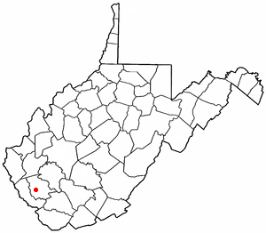
Switzer is an unincorporated community and census-designated place (CDP) in Logan County, West Virginia, United States. The CDP includes the neighboring unincorporated community of Micco. The total CDP population was 595 at the 2010 census.

<span class="mw-page-title-main">Ware (CDP), Massachusetts</span> Census-designated place in Massachusetts, United States

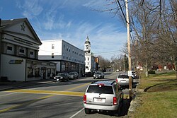
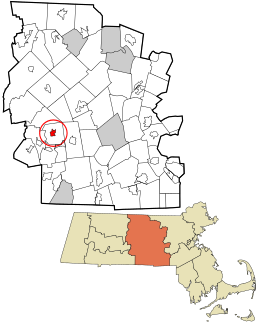
Ware is a census-designated place (CDP) comprising the main village in the town of Ware in Hampshire County, Massachusetts, United States. The population of the CDP was 6,170 at the 2010 census, out of a total town population of 9,872. It is part of the Springfield, Massachusetts Metropolitan Statistical Area.

<span class="mw-page-title-main">Walpole (CDP), Massachusetts</span> Census-designated place in Massachusetts, United States

Walpole is a small census-designated place (CDP) located within the much larger town of Walpole in Norfolk County, Massachusetts, United States. Walpole Town as it is called by the US Census Bureau, also includes a much larger population. The population of the Census Designated Place was 5,918 at the 2010 census.

<span class="mw-page-title-main">East Brookfield (CDP), Massachusetts</span> CDP in Massachusetts, United States

East Brookfield is a census-designated place (CDP) in the town of East Brookfield in Worcester County, Massachusetts, United States. The population was 1,323 at the 2010 census.

<span class="mw-page-title-main">Lunenburg (CDP), Massachusetts</span> CDP in Massachusetts, United States

Lunenburg is a census-designated place (CDP) in the town of Lunenburg in Worcester County, Massachusetts, United States. The population was 1,760 at the 2010 census.

<span class="mw-page-title-main">Oxford (CDP), Massachusetts</span> CDP in Massachusetts, United States

Oxford is a census-designated place (CDP) in the town of Oxford in Worcester County, Massachusetts, United States. The population was 6,103 at the 2010 census.

<span class="mw-page-title-main">Sturbridge (CDP), Massachusetts</span> CDP in Massachusetts, United States

Sturbridge is a census-designated place (CDP) in the town of Sturbridge in Worcester County, Massachusetts, United States. The population was 2,253 at the 2010 census.

<span class="mw-page-title-main">West Brookfield (CDP), Massachusetts</span> Census-designated place in Massachusetts, United States

West Brookfield is a census-designated place (CDP) in the town of West Brookfield in Worcester County, Massachusetts, United States. The population was 1,413 at the 2010 census.

<span class="mw-page-title-main">Winchendon (CDP), Massachusetts</span> Census-designated place in Massachusetts, United States

Winchendon is a census-designated place (CDP) in the town of Winchendon in Worcester County, Massachusetts, United States. The population was 4,213 at the 2010 census.

<span class="mw-page-title-main">Bangor Base, Washington</span> Census-designated place in Washington, United States

Bangor Base is a census-designated place (CDP) in Kitsap County, Washington, within U.S. Naval Base Kitsap on the Kitsap Peninsula. Its population was 6,054 at the 2010 census.

<span class="mw-page-title-main">Oxford (CDP), New Jersey</span> Populated place in Warren County, New Jersey, US

Oxford is an unincorporated community and census-designated place (CDP) located within Oxford Township in Warren County, New Jersey, United States, that was created as part of the 2010 United States Census. As of the 2010 Census, the CDP's population was 1,090.

References

  1. "2020 U.S. Gazetteer Files". United States Census Bureau. Retrieved May 21, 2022.
  2. "US Gazetteer files: 2010, 2000, and 1990". United States Census Bureau. February 12, 2011. Retrieved April 23, 2011.
  3. "Census of Population and Housing". Census.gov. Retrieved June 4, 2016.
  4. "U.S. Census website". United States Census Bureau . Retrieved January 31, 2008.