Indianola, Pittsburg County, Oklahoma

Last updated

Indianola, Oklahoma
OKMap-doton-Indianola.PNG
Location of Indianola, Oklahoma
Coordinates: 35°09′48″N95°46′33″W / 35.16333°N 95.77583°W / 35.16333; -95.77583
Country United States
State Oklahoma
County Pittsburg
Area
[1]
  Total0.32 sq mi (0.83 km2)
  Land0.32 sq mi (0.83 km2)
  Water0.00 sq mi (0.00 km2)
Elevation
[2]
663 ft (202 m)
Population
 (2020)
  Total148
  Density463.95/sq mi (178.92/km2)
Time zone UTC-6 (Central (CST))
  Summer (DST) UTC-5 (CDT)
ZIP code
74442
Area code(s) 539/918
FIPS code 40-36950 [3]
GNIS feature ID2412793 [2]

Indianola is a town in Pittsburg County, Oklahoma, United States. The population was 162 at the 2010 census, a loss of 15.2 percent compared to 191 at the 2000 census. [4]

Contents

History

Indianola probably began in 1875, when H. M. McElhany moved to the area and opened a one-room store. The store also served as a mail drop for local residents. The mail was delivered by horseback from the nearby town of Canadian, Oklahoma. McElhany stayed in business for about three years, then sold the store to Albert S. Cornelison and James H. Bynum. An actual post office was established at Indianola, Indian Territory on January 16, 1891, with Bynum being appointed as the first postmaster. [5]

At the time of its founding, Indianola was located in Tobucksy County, Choctaw Nation. [6]

According to the Encyclopedia of Oklahoma History and Culture, there are two versions of how the community acquired its name. One version says the name was on a stove in the general store. The other version says that the name honored Indianola, Mississippi. [5]

The first school in Indianola was organized in February 1895. In 1898, Lyman H. Perkins, a Choctaw farmer who had originally all the land on which Indianola was built, donated 1 acre (0.40 ha) for construction of a Methodist church. In 1902, the Fort Smith and Western Railway built a track north of town. Indianola quickly relocated to be adjacent to the track, and the residents built a new school building. Lyman Perkins and his wife donated 4 acres (1.6 ha) to the new town, which retained the name Indianola. The former site was simply called "Old Town." By 1910, the community claimed 781 residents, which was the all-time high. [5]

Geography

Indianola is located on the south bank of the South Canadian River, approximately 18 miles (29 km) north of McAlester. [5]

According to the United States Census Bureau, the town has a total area of 0.3 square miles (0.78 km2), all land. Indianola is 211 meters above sea level.

Demographics

Historical population
CensusPop.Note
1910 481
1920 415−13.7%
1930 378−8.9%
1940 311−17.7%
1950 3141.0%
1960 234−25.5%
1970 205−12.4%
1980 25423.9%
1990 171−32.7%
2000 19111.7%
2010 162−15.2%
2020 148−8.6%
U.S. Decennial Census [7]

As of the census [3] of 2000, there were 191 people, 72 households, and 52 families residing in the town. The population density was 613.3 inhabitants per square mile (236.8/km2). There were 76 housing units at an average density of 244.0 per square mile (94.2/km2). The racial makeup of the town was 90.58% White, 6.28% Native American, and 3.14% from two or more races.

There were 72 households, out of which 31.9% had children under the age of 18 living with them, 59.7% were married couples living together, 11.1% had a female householder with no husband present, and 26.4% were non-families. 25.0% of all households were made up of individuals, and 12.5% had someone living alone who was 65 years of age or older. The average household size was 2.65 and the average family size was 3.17.

In the town, the population was spread out, with 29.3% under the age of 18, 11.5% from 18 to 24, 22.5% from 25 to 44, 21.5% from 45 to 64, and 15.2% who were 65 years of age or older. The median age was 36 years. For every 100 females, there were 103.2 males. For every 100 females age 18 and over, there were 114.3 males.

The median income for a household in the town was $32,969, and the median income for a family was $32,031. Males had a median income of $23,750 versus $24,375 for females. The per capita income for the town was $18,908. About 7.3% of families and 7.8% of the population were below the poverty line, including none of those under the age of eighteen and 21.4% of those 65 or over.

Economy

Agriculture has been the mainstay of Indianola's economy, with cotton being the main cash crop. Other major crops produced around the town have been corn, grains, soybeans, peanuts, and onions. [5]

Related Research Articles

<span class="mw-page-title-main">Pittsburg County, Oklahoma</span> County in Oklahoma, United States

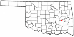
Pittsburg County is a county located in the U.S. state of Oklahoma. As of the 2020 census, the population was 43,773. Its county seat is McAlester. The county was formed from part of the Choctaw Nation in Indian Territory in 1907. County leaders believed that its coal production compared favorably with Pittsburgh, Pennsylvania at the time of statehood.

<span class="mw-page-title-main">Armstrong, Oklahoma</span> Town in Oklahoma, United States

Armstrong is a town in Bryan County, Oklahoma, United States, along the Blue River. The population was 105 at the 2010 census, a 25.2 percent decrease from the figure of 141 recorded in 2000. The town was named for Frank C. Armstrong, a member of the Dawes Commission.

<span class="mw-page-title-main">Fort Towson, Oklahoma</span> Town in Oklahoma, United States

Fort Towson is a town in Choctaw County, Oklahoma, United States. The population was 510 at the 2010 census, a 15.1 percent decline from the figure of 611 recorded in 2000. It was named for nearby Fort Towson, which had been established in May 1824 and named for General Nathan Towson, a hero of the War of 1812. The town of Fort Towson was established in 1902, after the Arkansas and Choctaw Railway reached eastern Choctaw County.

Kinta is a town in Haskell County, Oklahoma, United States. The population was 297 at the 2010 census, an increase of 22.2 percent over the figure of 243 recorded in 2000.

Whitefield is a town in northwestern Haskell County, Oklahoma, United States. The population was 377 at the 2020 census, compared with the figure of 391 recorded in 2010. It was named for Methodist bishop George Whitefield.

<span class="mw-page-title-main">Cowlington, Oklahoma</span> Town in Oklahoma, United States

Cowlington is a town in LeFlore County, Oklahoma. It is part of the Fort Smith metropolitan area. The population was 155 at the time of the 2010 census, a gain of 16.5 percent over the figure of 133 recorded in 2000.

<span class="mw-page-title-main">Heavener, Oklahoma</span> City in Oklahoma, United States

Heavener is a town in Le Flore County, Oklahoma, United States. The population was 3,414 at the 2010 census, an increase of 6.7 percent from 3,201 at the 2000 census. Heavener is notable for the Heavener Runestone just outside the city limits.

<span class="mw-page-title-main">Pocola, Oklahoma</span> Town in Oklahoma, United States

Pocola is a town in Le Flore County, Oklahoma, United States. It is part of the Fort Smith, Arkansas-Oklahoma metropolitan area. The population was 4,056 in 2010, a gain of 1.6 percent over the figure of 3,994 recorded in 2000. Pocola is a Choctaw word meaning "ten", the approximate distance in miles from Fort Smith, Arkansas.

<span class="mw-page-title-main">Shady Point, Oklahoma</span> Town in Oklahoma, United States

Shady Point, sometimes referred to as Shadypoint, is a town in Le Flore County, Oklahoma, United States. It is part of the Fort Smith, Arkansas-Oklahoma Metropolitan Statistical Area. The population was 1,026 at the 2010 census, a 21.0 percent increase over the figure of 848 recorded in 2000.

<span class="mw-page-title-main">Alderson, Oklahoma</span> Town in Oklahoma, United States

Alderson is a town in Pittsburg County, Oklahoma, United States. The population was 304 at the 2010 census.

<span class="mw-page-title-main">Ashland, Oklahoma</span> Town in Oklahoma, United States

Ashland is a town in Pittsburg County, Oklahoma, United States. The population was 66 at the 2010 census.

<span class="mw-page-title-main">Crowder, Oklahoma</span> Town in Oklahoma, United States

Crowder is a town in Pittsburg County, Oklahoma, United States. The population was 430 at the 2010 census.

<span class="mw-page-title-main">Haileyville, Oklahoma</span> City in Oklahoma, United States

Haileyville is a city in Pittsburg County, Oklahoma, United States. The population was 716 at the time of the 2020 United States census.

<span class="mw-page-title-main">Hartshorne, Oklahoma</span> City in Oklahoma, United States

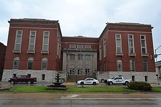
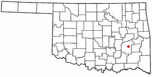
Hartshorne is a city in Pittsburg County, Oklahoma, United States. It is the second largest city in the county. The population was 1,947 at the time of the 2020 United States census.

<span class="mw-page-title-main">Kiowa, Oklahoma</span> Town in Oklahoma, United States

Kiowa is a town in Pittsburg County, Oklahoma, United States. The population was 731 at the 2010 census.

<span class="mw-page-title-main">Longtown, Oklahoma</span> CDP in Oklahoma, United States

Longtown is a census-designated place (CDP) and unincorporated community in Pittsburg County, Oklahoma, United States. The population was 2,397 at the 2000 census.

Pittsburg is a town in Pittsburg County, Oklahoma, United States. The population was 280 at the 2000 census.

<span class="mw-page-title-main">Quinton, Oklahoma</span> Town in Oklahoma, United States

Quinton is a town in Pittsburg County, Oklahoma, United States. The population was 1,051 at the 2010 census. The town was named for Elizabeth Quinton, who lived to be 116 years old. Her family still resides in and around the town of Quinton. Web address https://townofquinton.com/

<span class="mw-page-title-main">Savanna, Oklahoma</span> Town in Oklahoma, United States

Savanna is a town in Pittsburg County, Oklahoma, United States. The population was 686 at the 2010 census, a decline of 6.0 percent from the figure of 730 recorded in 2000. It is the hometown of former Harlem Globetrotter and 2014 NAIA Dunk Champion Tyler Inman.

<span class="mw-page-title-main">Fanshawe, Oklahoma</span> Town in Oklahoma, United States

Fanshawe is a town in Latimer and Le Flore counties in the U.S. state of Oklahoma. As of the 2020 Census, the town had a total population of 317. The Le Flore County portion of Fanshawe is part of the Fort Smith, Arkansas-Oklahoma Metropolitan Statistical Area.

References

  1. "ArcGIS REST Services Directory". United States Census Bureau. Retrieved September 20, 2022.
  2. 1 2 U.S. Geological Survey Geographic Names Information System: Indianola, Pittsburg County, Oklahoma
  3. 1 2 "U.S. Census website". United States Census Bureau . Retrieved January 31, 2008.
  4. "CensusViewer:Indianola, Oklahoma Archived August 19, 2014, at the Wayback Machine ."
  5. 1 2 3 4 5 "Indianola. Encyclopedia of Oklahoma History and Culture. Scott, George and Carol. Retrieved August 14, 2014.
  6. John W. Morris, Historical Atlas of Oklahoma, Plate 38.
  7. "Census of Population and Housing". Census.gov. Retrieved June 4, 2015.