Ingles Ferry

Last updated
Ingles Ferry
Ingles Ferry Post Card 1908.jpg
Ingles Ferry in 1908
USA Virginia location map.svg
Red pog.svg
Usa edcp location map.svg
Red pog.svg
Location Radford, Virginia, USA
Coordinates 37°6′3″N80°35′30″W / 37.10083°N 80.59167°W / 37.10083; -80.59167
Area2 acres (0.81 ha)
Built1772 (tavern)
NRHP reference No. 69000275 [1]
VLR No.077-0013
Significant dates
Added to NRHPNovember 25, 1969
Designated VLRMay 13, 1969 [2]

Ingles Ferry (sometimes referred to as English Ferry) is the site of a historic ferry crossing on the New River in western Virginia, near the city of Radford in Pulaski County, Virginia, United States. A tavern was opened there in 1772 and the ferry served soldiers and civilians until 1948. A bridge was built at the site in 1842 but was burned during the civil war. The tavern and replicas of the 18th-century home of the Ingles family can be seen nearby.

Contents

History

The ford was in use by Native Americans when Europeans arrived in the area, and initially was known as Eagle Bottom. [3] :75 William Ingles and his wife Mary Draper Ingles began developing a farm on the eastern side of the New River a few years after Mary's capture by Shawnee Indians and her subsequent escape in 1755. [4] As early as 1760, William was making money ferrying troops across the New River during the Anglo-Cherokee War, [3] :74 and, realizing the value of the ferry, purchased the land from Dr. Thomas Walker. [5] :109 The November 1762 official authorization of Ingles Ferry set fees at 3 pence for man or horse. [3] :74–75 In 1766, Ingles applied for a license to operate an ordinary (tavern) there. [6] :99–101 During the first few years of its existence, Indians frequently attacked the farm and ferry, [7] :84–93 [5] :7–8 and Ingles constructed a small stockaded blockhouse, which he named Fort Hope, to protect his family and neighbors. [8] :3

Tavern

The Ingles Ferry Tavern. Ingles Ferry Tavern 01.jpg
The Ingles Ferry Tavern.

With the help of his brother-in-law John Draper, William completed construction of the Ingles Ferry Hill Tavern and blacksmith shop on the Pulaski County side of the river in 1772. [9] [6] :99–101 The tavern was a popular meeting place for travelers, with Daniel Boone, [10] Andrew Jackson and George Rogers Clark among its patrons. [9] In April 1797, Louis Philippe I, Duke of Orléans and future King of France, crossed the river on the ferry, but did not stop at the tavern. [11] :51 William Clark (of Lewis and Clark) crossed on the ferry at least five times between 1801 and 1820. [3] :76 [12] :13

William Ingles was in charge of improving and maintaining the road leading to and from Ingles Ferry, known at the time as Ingles Ferry Road or English Ferry Road. [13] :36 It later became a main thoroughfare and was part of the Great Wagon Road and the Wilderness Road. [14]

On 8 May 1779, Lord Henry Hamilton, a British prisoner of war, was being escorted under guard to Williamsburg and spent the night at the home of William and Mary Ingles. In his journal, Hamilton described the Ingles' home:

8th. In the Evening crossed over in a ferry the new river or great Canhawa, and were kindly and hospitably received at the house of Colonel Ingles-- here we rested for an entire day...The Scenery about this house was romantic to a degree, the river very beautyfull, the hills well wooded, the low grounds well improved & well stocked, I thought...Mrs. Ingles had in her early years been carryed off with another young Woman by the Savages...however terror and distress had left so deep an impression on her mind that she appear'd absorbed in a deep melancholy. [15]

By 1780, William Ingles owned 907 acres, 67 cattle, [16] and ten slaves who ran his ferry and worked in his mills or in domestic capacities. [13] :69 [17] Following his death in 1782, his son Thomas Ingles took over the operation of Ingles Ferry, in partnership with his brother John and his cousin Crockett. [13] :75 [18] :51 Mary Draper Ingles died at Ingles Ferry in 1815. [19]

1814 map of Virginia showing "Inglish Fer[ry]" in the lower left quadrant. A new map of Virginia with Maryland, Delaware & v. LOC 2008621667.jpg
1814 map of Virginia showing "Inglish Fer[ry]" in the lower left quadrant.

Toll road

After the American Revolutionary War, thousands of immigrants poured through the New River Valley on their way to the newly opened territories in Kentucky and Tennessee. [20] :6 At times, as many as 30 or 40 wagons and teams would spend the night at the ferry. [12] :13 In 1805 William's son John Ingles and Andrew Lewis Jr. sponsored a bill before the Virginia General Assembly authorizing the Allegheny Turnpike (now known as the Valley Pike), so that tolls could be collected to support the maintenance of the road and the ferry, "because the cost of maintaining the previous public road in good condition had proved too great a burden." The turnpike, which opened in 1809, was 25 feet wide and more than seven miles in length. A gate and toll house were built near Shawsville. [13] :79

Thomas Ingles, grandson of William and Mary Draper Ingles, acquired the ferry in 1832. By 1834, an estimated 20,000 people were using the ferry annually, including slaves being transported westward. Geographer George William Featherstonhaugh observed a caravan of 300 slaves crossing the river at Ingles Ferry in 1834. [13] :75 In the 1830s, Thomas refurbished and enlarged the tavern, which is still standing, and built a ferry house. [6] :95–100 He and several others incorporated The Lafayette and Ingles Ferry Turnpike Company in 1839. [13] :115 The state of Virginia macadamized (paved) the road in 1840. [5] :114

The Ingles Bridge and later years

Remains of the Ingles Bridge on the New River. Bridge abutment at Ingles Ferry.jpg
Remains of the Ingles Bridge on the New River.

In 1842, Thomas Ingles built a covered bridge across the New River at a cost of $17,000, but he continued to offer a ferry service until 1847. [13] :76,116 The bridge was completed in February, 1843 [8] :4 and was 28 feet wide, 20 feet above the water, and 600 feet long. [12] :16 By 1848, the bridge tolls added up to nearly $1,900 a year, but Ingles stated that "a large portion of the county people are permitted to cross free of charge." [13] :117 During subsequent years, tolls could exceed $1,000 per month. [12] :16 [9] Revenue dropped after the construction in 1855 of the Virginia and Tennessee Railroad bridge, about two miles downstream from Ingles Ferry. [5] :114

On 9 May 1864, following the Battle of Cloyd's Mountain, the fleeing Confederate artillery crossed the New River on Ingles Bridge. [21] :52 The bridge was subsequently burned by Union forces, [5] :114 but the abutments on the west bank can still be seen. [13] :117 Ingles Ferry was the site of one of the final battles of the Civil War when, on 12 April 1865 (3 days after the Confederate surrender at Appomattox, Virginia), a detachment of Union troops attempting to rejoin General George Stoneman skirmished with Confederate infantry. The troops had not yet received news of the surrender. [12] :19 In 1865, the Ingles Ferry was again put into operation and continued until 1939 when the last flat-bottom ferry boat sank with a load of coal. [13] :76 The ferry was briefly reactivated from 1944-1948. [12] :56 The 1840 ferry house remained in use until it was destroyed by fire in 1967. [9]

1852 map of the Virginia and Tennessee Railroad showing Ingles Bridge at the far right of the page. Virginia and Tennessee Railroad map Dublin.png
1852 map of the Virginia and Tennessee Railroad showing Ingles Bridge at the far right of the page.

A watercolor sketch by Lewis Miller dated 26 August 1859 depicts the covered Ingles Bridge and the Ingles farm next to the tavern, as seen from Lovely Mount. [3] :74

Archaeology

Ingleside, the 1789 home of John Ingles at Ingles Ferry Ingleside 1789 home of John Ingles in Radford Virginia.jpg
Ingleside, the 1789 home of John Ingles at Ingles Ferry

The Ingles Bottom Archeological Sites feature excavations investigating historic and prehistoric occupation of the area, including the Ingles family home, farm, [22] stables, and a family cemetery. [23] John Ingles' 1789 home, known as Ingleside, is also nearby. [24] :414 Excavations initiated in 1974 covered 1400 square feet and found over 30,000 artifacts from the late 18th century. The dig uncovered a tannery as well as the foundation of the one-room cabin where Mary Draper Ingles lived during her final years, which measured 14.5 feet by 16 feet, and was still standing in 1910. Archaeologists also found evidence of a Native American village dating to 1250-1500 CE, as well as projectile points, bone tools and shellfish remains dating from ca. 3000-1500 BCE. [8] :4

Legacy

Historical Marker at Ingles Ferry. Historical Marker at Ingles Ferry.jpg
Historical Marker at Ingles Ferry.

In November 1969, the property was listed on the National Register of Historic Places and the Virginia Landmarks Register. [8] :4 [25] [26] The property’s three owners, all direct descendants of Mary Draper Ingles, have donated a permanent conservation easement of the 313-acre tract to the Virginia Outdoors Foundation and the Virginia Department of Historic Resources. The tavern as well as portions of the original Wilderness Road can be seen at the site. Replicas of the 18th-century home of the Ingles family can be seen on the eastern side of the river, and this area was also placed under permanent easement by the owner, another direct descendent of Mary Draper Ingles. [27]

A historical marker was placed in 2022 at the intersection of West Main Street and Wilderness Road. [28] A second historical marker at the intersection of Rock Road and Tyler Avenue, erected in 1998 by the Virginia Department of Historic Resources, describes Ingles Ferry Road. [29]

See also

Bibliography

Related Research Articles

<span class="mw-page-title-main">Radford, Virginia</span> Independent city in Virginia, United States

Radford is an independent city in the U.S. state of Virginia. As of 2020, the population was 16,070 by the United States Census Bureau. For statistical purposes, the Bureau of Economic Analysis combines the city of Radford with neighboring Montgomery County.

<span class="mw-page-title-main">Courtland, Virginia</span> Town in Southampton County, Virginia, US

Courtland is an incorporated town in Southampton County, Virginia, United States. It is the county seat of Southampton County.

<span class="mw-page-title-main">Jackson Ferry Shot Tower</span> United States historic place

The Jackson Ferry Shot Tower is a 75-foot (23 m) tall tower used for manufacturing lead shot located in Wythe County, Virginia and now adjacent to the New River Trail State Park, a lineal rail trail park connecting the historic towns of Pulaski and Galax, Virginia.

<span class="mw-page-title-main">Varina Farms</span> Historic house in Virginia, United States

Varina Farms, also known as Varina Plantation or Varina Farms Plantation or Varina on the James, is a plantation established in the 17th century on the James River about 10 miles (16 km) south of Richmond, Virginia. An 820-acre (330 ha) property was listed on the National Register of Historic Places in 1977 as "Varina Plantation". At that time it included two contributing buildings and one other contributing site.

<span class="mw-page-title-main">National Register of Historic Places listings in Virginia</span>

Buildings, sites, districts, and objects in Virginia listed on the National Register of Historic Places:

<span class="mw-page-title-main">Mary Draper Ingles</span> Virginia pioneer kidnapped by Native Americans

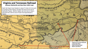
Mary Draper Ingles, also known in records as Mary Inglis or Mary English, was an American pioneer and early settler of western Virginia. In the summer of 1755, she and her two young sons were among several captives taken by Shawnee after the Draper's Meadow Massacre during the French and Indian War. They were taken to Lower Shawneetown at the Ohio and Scioto rivers. Ingles escaped with another woman after two and a half months and trekked 500 to 600 miles, crossing numerous rivers, creeks, and the Appalachian Mountains to return home.

<span class="mw-page-title-main">Draper's Meadow massacre</span> Attack by Shawnee warriors on a Virginia pioneer settlement in 1755.

The Draper's Meadow Massacre was an attack in July 1755, when the Draper's Meadow settlement in southwest Virginia, at the site of present-day Blacksburg, was raided by a group of Shawnee warriors, who killed at least four people including an infant, and captured five more. The Indians brought their hostages to Lower Shawneetown, a Shawnee village in Kentucky. One of the captives, Mary Draper Ingles, later escaped and returned home on foot through the wilderness. Although many of the circumstances of the massacre are uncertain, including the date of the attack, the event remains a dramatic story in the history of Virginia.

<span class="mw-page-title-main">Bridgeport Covered Bridge</span> Oldest covered bridge in California

The Bridgeport Covered Bridge is located in Bridgeport, Nevada County, California, southwest of French Corral and north of Lake Wildwood. It is used as a pedestrian crossing over the South Yuba River. The bridge was built in 1862 by David John Wood. Its lumber came from Plum Valley in Sierra County, California. The bridge was closed to vehicular traffic in 1972 and pedestrian traffic in 2011 due to deferred maintenance and "structural problems".

<span class="mw-page-title-main">Casselman Bridge</span> State park in Maryland, United States

The Casselman Bridge is a historic transportation structure on the Casselman River, located immediately east of Grantsville in Garrett County, Maryland. The bridge was built in 1813-1814 as part of the National Road. Historic markers posted at each end read:

Erected 1813 by David Shriver Jr.,
Sup't of the "Cumberland Road". This 80 foot span
was the largest stone arch in America
at the time. It was continuously
used from 1813 to 1933.

<span class="mw-page-title-main">Emmanuel Church at Brook Hill</span> Historic church in Virginia, United States

The Emmanuel Church at Brook Hill, in the historic community of Brook Hill in Henrico County, Virginia, is a historic Episcopal church.

<span class="mw-page-title-main">Tree Hill (Richmond, Virginia)</span> Historic house in Virginia, United States

Tree Hill near Richmond, Virginia, in Henrico County, Virginia, is a Greek Revival style plantation house overlooking the James River about two miles east of downtown Richmond near the intersection of the historic Osborne Turnpike and New Market Road. Currently still a private farm, but expected to become partly a park after housing and commercial development, it was once owned by Richmond distiller and landowner Franklin Stearns, a prominent Unionist during the American Civil War. Centuries earlier, it had been a Native American camp site, and the birthplace of powerful chief Powhatan (d.1618).

<span class="mw-page-title-main">Ferry Plantation House</span> Historic house in Virginia, United States

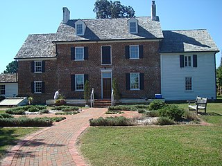
Ferry Plantation House, or Old Donation Farm, Ferry Farm, Walke Manor House, is a brick house in the neighborhood of Old Donation Farm in Virginia Beach, Virginia. The site dates back to 1642 when Savill Gaskin started the second ferry service in Hampton Roads to carry passengers on the Lynnhaven River to the nearby county courthouse and to visit plantations along the waterway. A cannon was used to signal the ferry, which had 11 total stops along the river. The first ferry service was started nearby by Adam Thoroughgood.

Newbern is an unincorporated community in Pulaski County, in the U.S. state of Virginia. From 1839 until the court house burned in 1892, Newbern was the county seat of Pulaski County

<span class="mw-page-title-main">Windsor Shades</span> Historic house in Virginia, United States

Windsor Shades is located on the Pamunkey River in Sweet Hall, Virginia, United States. It is listed on the National Register of Historic Places. Archeological native artifacts found on the property surrounding the house suggest it was the site of Kupkipcok, a Pamunkey village noted on John Smith's 1609 map.

<span class="mw-page-title-main">Ingles Bottom Archeological Sites</span> Archaeological sites in Virginia, United States

Ingles Bottom Archeological Sites is a set of archaeological sites, and national historic district located along the New River near Radford, Montgomery County, Virginia. The district encompasses a variety of archaeological sites relating to human occupation from 8000 B.C. to the present. It includes the site of a log cabin built about 1762, as the home of William Ingles (1729-1782) and his wife Mary Draper Ingles (1732-1815). The property also includes the site of a stable, the Ingles family cemetery, a tannery, a blacksmith shop, and the Ingles Ferry Tavern.

<span class="mw-page-title-main">Glencoe Museum</span> Historic house in Virginia, United States

Glencoe Museum is located in a Victorian house in west downtown Radford, Virginia. The house was built in 1870 in the 19th century Victorian style, specifically Second Empire, and was the home of Confederate Brigadier General Gabriel C. Wharton. It is a large, two-story, five-bay, brick dwelling, and originally had quite extensive grounds. The original house had a barn, chicken coop, smoke house, and an ice house.

Samuel Stalnaker was an explorer, trapper, guide and one of the first settlers on the Virginia frontier. He established a trading post, hotel and tavern in 1752 near what is now Chilhowie, Virginia. He was held captive by Shawnee Indians at Lower Shawneetown in Kentucky for almost a year, before escaping and traveling over 460 miles to Williamsburg, Virginia, to report on French preparations to attack English settlements in Virginia and Pennsylvania. He later served as a guide under George Washington during the French and Indian War.

William Ingles, also spelled Inglis, Ingliss, Engels, or English, was a colonist and soldier in colonial Virginia. He participated in the Sandy Creek Expedition and was a signatory of the Fincastle Resolutions. He was eventually promoted to colonel in the Virginia Regiment. His wife, Mary Draper Ingles, was captured by Shawnee warriors and held captive for months before escaping and walking several hundred miles to her settlement. William's sons, Thomas and George, were also held captive, although William was able to ransom his son Thomas in 1768. William Ingles established Ingles Ferry in southwestern Virginia.

Thomas Ingles was a Virginia pioneer, frontiersman and soldier. He was the son of William Ingles and Mary Draper Ingles. He, his mother and his younger brother were captured by Shawnee Indians and although his mother escaped, Thomas remained with the Shawnee until age 17, when his father paid a ransom and brought him back to Virginia. He later served in the Virginia militia, reaching the rank of colonel by 1780.

Dunkard's Bottom was a Schwarzenau Brethren religious community established on the New River in the mid-1740s by brothers Samuel, Gabriel and Israel Eckerlin and Alexander Mack Jr. It flourished for only a few years until most of the settlers decided to return to Pennsylvania because living conditions at Dunkard's Bottom were too harsh. The Eckerlins sold their property in 1753 and moved to what is now West Virginia. The property changed hands several times until the construction of the Claytor Dam in 1939, which submerged the area of Dunkard's Bottom under Claytor Lake.

References

  1. "National Register Information System". National Register of Historic Places . National Park Service. March 13, 2009.
  2. "Virginia Landmarks Register". Virginia Department of Historic Resources. Retrieved 5 June 2013.
  3. 1 2 3 4 5 Jim Page and Sherry Joines Wyatt, "The Nigh and Best Way": The Early Development of Roads in Montgomery County", The Smithfield Review, Volume 21, 2017.
  4. Ingels History
  5. 1 2 3 4 5 Hale, John P., Trans-Allegheny Pioneers (West Virginia and Ohio): Historical Sketches of the First White Settlers West of the Alleghenies, 1748 and After (1886), Heritage Books, reprint, 2009.
  6. 1 2 3 Smith, Conway Howard. Colonial Days in the Land that Became Pulaski County. Pulaski County Library Board, 1975.
  7. History of the Great Kanawha Valley (West Virginia): With Family History and Biographical Sketches: a Statement of Its Natural Resources, Industrial Growth and Commercial Advantages. Westminster, Md: Heritage Books, 2007
  8. 1 2 3 4 Junius R. Fishburne, "Nomination form, Ingles Bottom Archaeological Sites," Virginia Department of Historic Resources, June 15, 1976
  9. 1 2 3 4 Ingles Ferry, Virginia Department of Historic Resources, June 2, 2022.
  10. Evan Benjamin and Daniel Holbrook. "Ingles Farm." Clio: Your Guide to History. May 4, 2017. Accessed September 11, 2023.
  11. Louis Philippe. Diary of My Travels in America: Louis Philippe, King of France, 1830-1848. New York: Delacorte Press, 1977.
  12. 1 2 3 4 5 6 Elmer Johnson, "Radford Then and Now: A Pictorial History," American Bicentennial Commission of Radford, Virginia, 1975
  13. 1 2 3 4 5 6 7 8 9 10 "Montgomery County Reconnaissance Level Survey", Vol. 1, July 1986, Historic Sites Survey: Virginia Division of Historic Landmarks.
  14. Ann Brush Miller, Betty E. Spillman and Shirley P. Thomas, "Historic Roads of Virginia: Fincastle County Road Orders, 1773-1776," New River Historical Society, 2007
  15. "Henry Hamilton's Journal: A Prisoner of War, March 8 to June 16, 1779", Indiana Historical Bureau website.
  16. Richard Osborn, "William Preston and the Revolutionary Settlement", Journal of Backcountry Studies, vol. 3, no. 2, July, 2010.
  17. 1782 Montgomery County, Virginia Personal Property Tax List
  18. Kegley, Frederick Bittle., Kegley, Mary B. Early Adventurers on the Western Waters: The New River of Virginia in pioneer days, 1745-1800. Green Publishers, 1980.
  19. Ryan S. Mays, "The Draper's Meadows Settlement (1746-1756)," Part II, The Smithfield Review, Volume 19, 2015
  20. Hugh Miller, "Prehistoric and Historic Resources of Montgomery County, Virginia," Virginia Department of Natural Resources, 2 Sept 1989
  21. Pulaski County Reconnaissance Level Survey, National Park Service, Virginia Department of Historic Resources, September 1985
  22. "Ingles Farm," Radford Tourism
  23. "Ingels History: Ingles Ferry, Virginia
  24. Calder Loth, The Virginia Landmarks Register, Virginia Department of Historic Resources, 1999
  25. Virginia Outdoors Foundation Archived 2010-01-15 at the Wayback Machine Retrieved 16 July 2010
  26. Virginia Historic Landmarks Commission Staff (May 1969). "National Register of Historic Places Inventory/Nomination: Ingles Ferry" (PDF). Virginia Department of Historic Resources. and Accompanying two photos
  27. Jason McGarvey, "Historic Ingles Ferry Farm Permanently Protected," Virginia Outdoors Foundation News, August 29, 2009
  28. [https://cardinalnews.org/2022/09/27/state-approves-historical-marker-for-ingles-ferry-in-radford/ "State approves historical marker for Ingles Ferry in Radford It is one of eight new markers approved statewide." Cardinal News, September 27, 2022]
  29. Bernard Fisher, "Ingles Ferry Road Historical Marker," April 4, 2011