
Interstate 81 (I-81) is a north–south Interstate Highway in the eastern part of the United States. Its southern terminus is at I-40 in Dandridge, Tennessee; its northern terminus is on Wellesley Island, New York at the Canadian border, where the Thousand Islands Bridge connects it to Highway 137 and ultimately to Highway 401, the main Ontario freeway connecting Detroit via Toronto to Montreal. The major metropolitan areas along the route of I-81 include the Tri-Cities of Tennessee; Roanoke in Virginia; Harrisburg and the Wyoming Valley in Pennsylvania; and Syracuse in New York.

Rockingham County is a county located in the U.S. state of Virginia. As of the 2020 census, the population was 83,757. Its county seat is the independent city of Harrisonburg.

Mount Jackson is a town in Shenandoah County, Virginia, United States. The population was 1,994 at the 2010 census.

The Shenandoah Valley is a geographic valley and cultural region of western Virginia and the Eastern Panhandle of West Virginia in the United States. The valley is bounded to the east by the Blue Ridge Mountains, to the west by the eastern front of the Ridge-and-Valley Appalachians, to the north by the Potomac River and to the south by the James River. The cultural region covers a larger area that includes all of the valley plus the Virginia highlands to the west, and the Roanoke Valley to the south. It is physiographically located within the Ridge and Valley province and is a portion of the Great Appalachian Valley.

U.S. Route 11 or U.S. Highway 11 (US 11) is a major north–south United States Numbered Highway extending 1,645 miles (2,647 km) across the eastern U.S. The southern terminus of the route is at US 90 in Bayou Sauvage National Wildlife Refuge in eastern New Orleans, Louisiana. The northern terminus is at the Rouses Point–Lacolle 223 Border Crossing in Rouses Point, New York. The route continues across the border into Canada as Route 223. US 11, created in 1926, maintains most of its original route. The route north of Knoxville, Tennessee, follows a route similar to Interstate 81 (I-81). While it is signed as a north–south route, it physically travels in a northeast–southwest direction.
U.S. Route 250 is a route of the United States Numbered Highway System, and is a spur of U.S. Route 50. It currently runs for 514 miles (827 km) from Richmond, Virginia to Sandusky, Ohio. It passes through the states of Virginia, West Virginia, and Ohio. It goes through the cities of Richmond, Charlottesville, Staunton, and Waynesboro, Virginia; and Wheeling, West Virginia. West of Pruntytown, West Virginia, US 250 intersects and forms a short overlap with its parent US 50.
The Northwestern Turnpike is a historic road in West Virginia, important for being historically one of the major roads crossing the Appalachians, financed by the Virginia Board of Public Works in the 1830s. In modern times, west of Winchester, Virginia, U.S. Route 50 follows the path of the Northwestern Turnpike into West Virginia, whose major Corridor D project follows the western section of the original Northwestern Turnpike.
State Route 259 is a primary state highway in the U.S. state of Virginia. The state highway runs a total of 26.80 miles (43.13 km) in two sections. The southern section, in northern Rockingham County, has a length of 21.81 miles (35.10 km) from Interstate 81 (I-81) and U.S. Route 11 at Mauzy through Broadway to the West Virginia state line into Mathias. The northern section, in western Frederick County, covers 4.99 miles (8.03 km) from the West Virginia state line north to US 50 at Gore. The two sections of SR 259 are joined by West Virginia Route 259.

U.S. Route 50 is a transcontinental highway which stretches from Ocean City, Maryland to West Sacramento, California. In the U.S. state of Virginia, US 50 extends 86 miles (138 km) from the border with Washington, D.C. at a Potomac River crossing at Rosslyn in Arlington County to the West Virginia state line near Gore in Frederick County.
U.S. Route 11 (US 11) is a north–south United States Numbered Highway in western Virginia. At 339 miles (546 km), it is the second longest numbered route and longest primarily north–south route in the state. It enters the state from Tennessee as the divided routes US 11E and US 11W at Bristol, roughly follows the West Virginia border through the Blue Ridge Mountains and Shenandoah Valley, and enters the Eastern Panhandle of West Virginia from Frederick County. Most of the route closely parallels I-81. From south to north, US 11 serves the cities and towns of Bristol, Abingdon, Wytheville, Pulaski, Radford, Christiansburg, Roanoke, Lexington, Staunton, Harrisonburg, Strasburg, and Winchester. As one of the original U.S. Highways, it was first designated through Virginia in 1926 and has largely followed the same route since. Prior to the construction of the Interstate Highway System, it was the primary long-distance route for traversing the western part of the state. Much of it roughly follows the Great Wagon Road, a colonial-era road that followed the Appalachian Mountains from Georgia to Pennsylvania.

U.S. Route 33 is a part of the U.S. Highway System that runs from Elkhart, Indiana to Richmond, Virginia. In Virginia, the U.S. Highway runs 135.60 miles (218.23 km) from the West Virginia state line near Rawley Springs east to its eastern terminus at SR 33 in Richmond. US 33 is the primary east–west highway of Rockingham County, which lies in the Shenandoah Valley. The highway connects the independent city of Harrisonburg, the town of Elkton, and an entrance to Shenandoah National Park. East of the Blue Ridge Mountains, US 33 connects the Piedmont communities of Stanardsville, Gordonsville, and Louisa. The U.S. Highway is a major suburban and urban route in the Richmond metropolitan area. Within Richmond, US 33 runs concurrently with US 250. SR 33 continues from US 33's eastern terminus as a state-numbered extension of the U.S. Highway that connects Richmond with Virginia's Middle Peninsula.

The Great Indian Warpath (GIW)—also known as the Great Indian War and Trading Path, or the Seneca Trail—was that part of the network of trails in eastern North America developed and used by Native Americans which ran through the Great Appalachian Valley. The system of footpaths extended from what is now upper New York to deep within Alabama. Various Native peoples traded and made war along the trails, including the Catawba, numerous Algonquian tribes, the Cherokee, and the Iroquois Confederacy. The British traders' name for the route was derived from combining its name among the northeastern Algonquian tribes, Mishimayagat or "Great Trail", with that of the Shawnee and Delaware, Athawominee or "Path where they go armed".
The Staunton–Parkersburg Turnpike was built in what is now the U.S. states of Virginia and West Virginia during the second quarter of the 19th century to provide a roadway from Staunton, Virginia and the upper Shenandoah Valley to the Ohio River at present-day Parkersburg, West Virginia. Engineered by Claudius Crozet through the mountainous terrain, it was a toll road partially funded by the Virginia Board of Public Works. Control of this road became crucial during the American Civil War. Today, the Staunton-Parkersburg Turnpike can be largely traversed by following West Virginia Route 47 east from Parkersburg to Linn, then U.S. Route 33 east through Weston and Buckhannon to Elkins, then U.S. Route 250 southeast through Beverly, Huttonsville, crossing the West Virginia/Virginia state line to Staunton, Virginia.
The city of Winchester, Virginia, and the surrounding area, were the site of numerous battles during the American Civil War, as contending armies strove to control the lower Shenandoah Valley. Winchester changed hands more often than any other Confederate city.
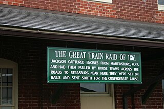
Colonel Stonewall Jackson's operations against the Baltimore and Ohio Railroad in 1861 were aimed at disrupting the critical railroad used heavily by the opposing Union Army as a major supply route. A second goal was to capture the maximum number of locomotives and cars for use in the Confederate States of America. During this point in the war, the state of Maryland's stance was not yet determined. The B&O Railroad, then owned by the state of Maryland, ran through Maryland and along the Potomac River Valley in its pass through the Appalachian Mountains, but took a crucial turn at Harpers Ferry and passed south, through Virginia and Martinsburg while crossing the Shenandoah Valley. The railroad then continued on through much of present-day West Virginia, which then was still part of Virginia, meaning that a major portion of the route went through a state which later seceded.
The Manassas Gap Railroad (MGRR) ran from Mount Jackson, Virginia, to the Orange and Alexandria Railroad's Manassas Junction, which later became the city of Manassas, Virginia. Chartered by the Virginia General Assembly in 1850, the MGRR was a 4 ft 8 in narrow gauge line whose 90 completed miles of track included 38 miles (61 km) of 60 pounds-per-yard T-rail and 52 miles (84 km) of 52 pounds-per-yard T-rail. A total of nine locomotives and 232 cars were operated on the line, serving 20 stations.
U.S. Route 250 is a part of the U.S. Highway System that runs from Sandusky, Ohio to Richmond, Virginia. In Virginia, the highway runs 166.74 miles (268.34 km) from the West Virginia state line near Hightown east to its eastern terminus at US 360 in Richmond. US 250 is the main east–west highway of Highland County, which is known as Virginia's Little Switzerland; the highway follows the path of the 19th century Staunton and Parkersburg Turnpike. From Staunton east to Richmond, the highway serves as the local complement to Interstate 64 (I-64), roughly following the 18th century Three Notch'd Road through Waynesboro and Charlottesville on its way through the Shenandoah Valley, its crossing of the Blue Ridge Mountains at Rockfish Gap, and the Piedmont. In the Richmond metropolitan area, US 250 is known as Broad Street, a major thoroughfare through the city's West End and downtown areas.
The Winchester and Potomac Railroad (W&P) was a railroad in the southern United States, which ran from Winchester, Virginia, to Harpers Ferry, West Virginia, on the Potomac River, at a junction with the Baltimore and Ohio Railroad (B&O). It played a key role in early train raids of the B&O during the beginning months of the American Civil War.

1st Maryland Cavalry Battalion, Potomac Home Brigade, originally organized as the 1st Potomac Home Brigade Cavalry, "Cole's Cavalry" was formed under the guidance of Henry A. Cole. There are also references to it being designated as Cole's 1st Volunteer Maryland Cavalry. The unit, a battalion, originally consisted of four companies, A, B, C & D and was initially enlisted between August 10 and November 27, 1861.

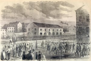
![A drawing entitled "the escape of Stonewall Jackson's Army down the valley pike at Strausburg [sic], Va." U.S. Library of Congress Collection Valley Pike, 1862.jpg](http://upload.wikimedia.org/wikipedia/commons/thumb/c/cd/Valley_Pike%2C_1862.jpg/220px-Valley_Pike%2C_1862.jpg)
