Cartography is the study and practice of making and using maps. Combining science, aesthetics and technique, cartography builds on the premise that reality can be modeled in ways that communicate spatial information effectively.

A geographic information system (GIS) consists of integrated computer hardware and software that store, manage, analyze, edit, output, and visualize geographic data. Much of this often happens within a spatial database; however, this is not essential to meet the definition of a GIS. In a broader sense, one may consider such a system also to include human users and support staff, procedures and workflows, the body of knowledge of relevant concepts and methods, and institutional organizations.

Iran's telecommunications industry is almost entirely state-owned, dominated by the Telecommunication Company of Iran (TCI). Fixed-line penetration in 2004 was relatively well-developed by regional standards, standing at 22 lines per 100 people, higher than Egypt with 14 and Saudi Arabia with 15, although behind the UAE with 27. Iran had more than 1 mobile phone per inhabitant by 2012.

Environmental Systems Research Institute, Inc., doing business as Esri, is an American multinational geographic information system (GIS) software company headquartered in Redlands, California. It is best known for its ArcGIS products. With 40% market share as of 2011, Esri is one of the world's leading supplier of GIS software, web GIS and geodatabase management applications.

Information and communications technology (ICT) is an extensional term for information technology (IT) that stresses the role of unified communications and the integration of telecommunications and computers, as well as necessary enterprise software, middleware, storage and audiovisual, that enable users to access, store, transmit, understand and manipulate information.
THOMAS was the first online database of United States Congress legislative information. A project of the Library of Congress, it was launched in January 1995 at the inception of the 104th Congress and retired on July 5, 2016; it has been superseded by Congress.gov.
A GIS software program is a computer program to support the use of a geographic information system, providing the ability to create, store, manage, query, analyze, and visualize geographic data, that is, data representing phenomena for which location is important. The GIS software industry encompasses a broad range of commercial and open-source products that provide some or all of these capabilities within various information technology architectures.

Web mapping or an online mapping is the process of using, creating, and distributing maps on the World Wide Web, usually through the use of Web geographic information systems. A web map or an online map is both served and consumed, thus, web mapping is more than just web cartography, it is a service where consumers may choose what the map will show.

In geomarketing and internet marketing, geotargeting is the method of delivering different content to visitors based on their geolocation. This includes country, region/state, city, metro code/zip code, organization, IP address, ISP, or other criteria. A common usage of geotargeting is found in online advertising, as well as internet television with sites such as iPlayer and Hulu. In these circumstances, content is often restricted to users geolocated in specific countries; this approach serves as a means of implementing digital rights management. Use of proxy servers and virtual private networks may give a false location.
Geobytes is a global company that provides geolocation and anti-spam software. Geobytes was incorporated in Delaware, USA in 1999.
Collaborative mapping, also known as citizen mapping, is the aggregation of Web mapping and user-generated content, from a group of individuals or entities, and can take several distinct forms. With the growth of technology for storing and sharing maps, collaborative maps have become competitors to commercial services, in the case of OpenStreetMap, or components of them, as in Google Map Maker, Waze and Yandex Map Editor.
Distributed GIS refers to GI Systems that do not have all of the system components in the same physical location. This could be the processing, the database, the rendering or the user interface. It represents a special case of distributed computing, with examples of distributed systems including Internet GIS, Web GIS, and Mobile GIS. Distribution of resources provides corporate and enterprise-based models for GIS. Distributed GIS permits a shared services model, including data fusion based on Open Geospatial Consortium (OGC) web services. Distributed GIS technology enables modern online mapping systems, Location-based services (LBS), web-based GIS and numerous map-enabled applications. Other applications include transportation, logistics, utilities, farm / agricultural information systems, real-time environmental information systems and the analysis of the movement of people. In terms of data, the concept has been extended to include volunteered geographical information. Distributed processing allows improvements to the performance of spatial analysis through the use of techniques such as parallel processing.
MetaCarta is a software company that developed one of the first search engines to use a map to find unstructured documents. The product uses natural language processing to georeference text for customers in defense, intelligence, homeland security, law enforcement, oil and gas companies, and publishing. The company was founded in 1999 and was acquired by Nokia in 2010. Nokia subsequently spun out the enterprise products division and the MetaCarta brand to Qbase, now renamed to Finch.
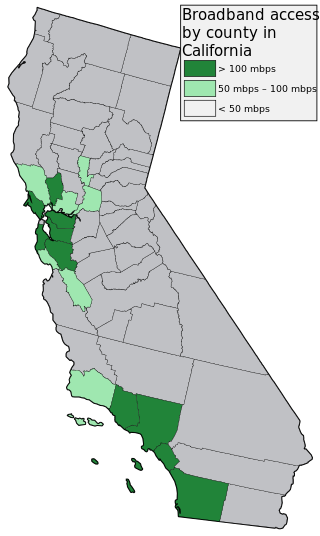
Broadband mapping in the United States are efforts to describe geographically how Internet access service from telephone and cable TV companies is available in terms of available speed and price. Mapping has been done on the national as well as the state level. The efforts are seen as preliminary steps towards broadband universal service.
Global Internet usage is the number of people who use the Internet worldwide.
Matthew Zook is an American geographer and professor in the Department of Geography, University of Kentucky. He studies the geography of the Internet, the GeoWeb, economic geography and domain names In 2009 Matthew Zook and Mark Graham cofounded the FloatingSheep blog to understand the interactions between the GeoWeb and the offline world. In 2011 Zook cofounded the New Mappings Collaboratory at the University of Kentucky to focus on public engagement in Lexington, 'big data' and user-generated Internet content, as well as the affordances of place-based thinking, analysis, and representation.
Tactician Corporation is a developer and provider of GIS desktop software, SaaS web software, and business intelligence consulting services internationally. The company has its headquarters in Massachusetts, United States.

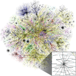
Wikipedia has been criticized for the inequality in the distribution of its volunteer created content with respect to the geographical association of article subjects. The research shows that despite considerable differences of this distribution depending on the language of Wikipedia, there is a common trend towards more content related to the United States and Western Europe coupled with the scarcity of information about certain regions in the rest of the world.

Internet GIS, or Internet geographic information system (GIS), is a term that refers to a broad set of technologies and applications that employ the Internet to access, analyze, visualize, and distribute spatial data. Internet GIS is an outgrowth of traditional GIS, and represents a shift from conducting GIS on an individual computer to working with remotely distributed data and functions. Two major issues in GIS are accessing and distributing spatial data and GIS outputs. Internet GIS helps to solve that problem by allowing users to access vast databases impossible to store on a single desktop computer, and by allowing rapid dissemination of both maps and raw data to others. These methods include both file sharing and email. This has enabled the general public to participate in map creation and make use of GIS technology.

Web GIS, or Web Geographic Information Systems, are GIS that employ the World Wide Web to facilitate the storage, visualization, analysis, and distribution of spatial information over the Internet. The World Wide Web, or the Web, is an information system that uses the internet to host, share, and distribute documents, images, and other data. Web GIS involves using the World Wide Web to facilitate GIS tasks traditionally done on a desktop computer, as well as enabling the sharing of maps and spatial data. While Web GIS and Internet GIS are sometimes used interchangeably, they are different concepts. Web GIS is a subset of Internet GIS, which is itself a subset of distributed GIS, which itself is a subset of broader Geographic information system. The most common application of Web GIS is Web mapping, so much so that the two terms are often used interchangeably in much the same way as Digital mapping and GIS. However, Web GIS and web mapping are distinct concepts, with web mapping not necessarily requiring a Web GIS.