
Hopfgarten im Brixental is a market town in the Austrian state of Tyrol in the Kitzbühel district. It is located at an elevation of 622 m above sea level. With an area of 166.57 km² it is the largest municipality in the district, and among the largest in Tyrol.

Altenmarkt im Pongau is a small town in the Austrian state of Salzburg.

Haus im Ennstal is a village in central Austria, located in the Liezen district of Styria. It is an important town on the Enns river.

Hatting is a municipality in the district Innsbruck-Land and is located 18 km west of the city of Innsbruck. The village was mentioned around 11th century for the first time.

Wallern im Burgenland is a town in the northeastern part of Burgenland in Austria. It is located in the southern part of the Neusiedl am See district east of the Neusiedlersee, on Route 52 about 5 km (3.1 mi) north of the border at the artificial channel Einserkanal with Hungary.
Leopoldsdorf im Marchfelde is a town in the district of Gänserndorf in the Austrian state of Lower Austria.

Gleisdorf is a town in the district of Weiz in the Austrian state of Styria.

Oberperfuss is a municipality in the district of Innsbruck-Land in the Austrian state of Tyrol located about 15 km (9.3 mi) west of Innsbruck at the entrance of the Sellrain Valley. It was mentioned in documents around 1083 for the first time.

Gries im Sellrain is a municipality in the Sellrain Valley in the western district of Innsbruck-Land. The village lies in the valley and the Melach River flows through it.

Grinzens is a municipality in the Austrian state of Tyrol in the district of Innsbruck-Land. As of January 2015, its population is 1414. It lies southwest of the city of Innsbruck at an elevation of 945 m.
Kematen in Tirol is a municipality in the district Innsbruck-Land located about 12 km west of Innsbruck. The Melach river flows into the Inn river in Kematen. Kematen was first mentioned as „Caminata“ around 600.

Mieders is a municipality in the southern part of the district Innsbruck-Land in the Austrian state of Tyrol. It is located on the right side of the Stubaital 10.60 km south of Innsbruck.

Neustift im Stubaital is a municipality in the district Innsbruck-Land in the Austrian state of Tyrol. It is the third largest municipality of Tyrol in area. It is a major tourist centre, with more than 1 million overnight stays per year.
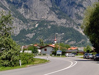
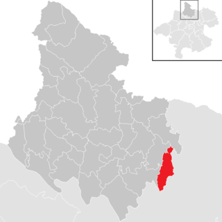
Oberhofen im Inntal is a municipality in the western district of Innsbruck-Land in the Austrian state of Tyrol located 21 km west of Innsbruck and 2.6 km east of Telfs. Once a part of Pfaffenhofen it became an own municipality in 1786.

Unterperfuss is a municipality in the district of Innsbruck-Land in the Austrian state of Tyrol located 15 km west of Innsbruck and is one of the smallest villages of Tyrol. The area is restricted in the north by the Inn River and in the east by the Melach River. Unterperfuss has many facilities for horse-riding.
Sellrain is a municipality in the district of Innsbruck-Land in the Austrian state of Tyrol located 14.40 km southwest of Innsbruck in the Sellrain Valley. The Melach River and its tributary the Fotscherbach flow through it. Most people in the village are farmers and also have another job in the neighboring Innsbruck. There are two Catholic churches in the village St. Quirin and St. Anna. They are both over 300 years old.
Sankt Sigmund im Sellrain is a municipality in western Austria, in the district of Innsbruck-Land in the state of Tyrol located 23.3 kilometres (14.5 mi) southeast of Innsbruck, in the deepest part of the Sellrain Valley. It has a large area and the highest elevation. The main source of income is winter tourism.

Sankt Veit im Pongau is a market town in the St. Johann im Pongau district in the Austrian state of Salzburg. St.Veit is the first healthy climate spa town in Salzburg. Submontane to the "Hochglocker" there is the 1912 founded sanatorium. Author Thomas Bernhard was treated in there and he also wrote a book about his residence at the clinic.

Sankt Marienkirchen am Hausruck is a municipality in the district of Ried im Innkreis in the Austrian state of Upper Austria.
Sankt Veit im Mühlkreis is a municipality in the district of Rohrbach in the Austrian state of Upper Austria.

