A satellite tornado is a tornado that revolves around a larger, primary tornado and interacts with the same mesocyclone. Satellite tornadoes occur apart from the primary tornado and are not considered subvortices; the primary tornado and satellite tornadoes are considered to be separate tornadoes. The cause of satellite tornadoes is not known. Such tornadoes are more often anticyclonic than are typical tornadoes and these pairs may be referred to as tornado couplets. Satellite tornadoes commonly occur in association with very powerful, large, and destructive tornadoes, indicative also of the strength and severity of the parent supercell thunderstorm.

The tornado outbreak of June 16–18, 2014, was a tornado outbreak concentrated in the Great Plains and the Midwestern United States. Two tornadoes also occurred in Ontario. The severe weather event most significantly affected the state of Nebraska, where twin EF4 tornadoes killed two and critically injured twenty others in and around the town of Pilger on the evening of June 16. The two Pilger tornadoes were part of a violent tornado family that produced four EF4 tornadoes and was broadcast live on television. The outbreak went on to produce multiple other strong tornadoes across the northern Great Plains states throughout the next two days.

On December 23, 2015, an outbreak of supercell thunderstorms produced tornadoes across northern Mississippi and middle Tennessee, resulting in 13 tornado-related deaths and numerous injuries. Other tornadoes occurred as far north as Indiana and Michigan. Scattered tornado activity continued over the next two days before the outbreak ended. This was the first of two deadly tornado outbreaks to impact the southern United States during December 2015 with the other occurring just a day after this one ended.

A significant four-day outbreak of tornadoes impacted areas across the High Plains, central Midwest, and parts of the Ohio Valley in early May. The outbreak also produced the first EF4 tornado of the year in Katie, Oklahoma on May 9, where one death occurred. An EF3 tornado near Connerville, Oklahoma also killed a person that day. Other notable tornadoes included two large EF2 tornadoes in Colorado on May 7, a large EF2 tornado near Catherine, Kansas on May 8, and a destructive EF3 tornado that struck Mayfield, Kentucky on May 10. Overall, 57 tornadoes were confirmed.

A deadly tornado outbreak severely impacted the Southern United States, and also affected Iowa and Nebraska to a lesser extent, between November 27–30, 2016. The strongest tornadoes of the event affected Alabama and Tennessee during the late evening of November 29 and into the early morning hours of November 30. Overall, this outbreak produced 48 tornadoes, killed six people, and injured many others.

The tornado outbreak of March 6–7, 2017 was a widespread severe weather and tornado outbreak that affected portions of the Midwestern United States in the overnight hours of March 6–7. Occurring just days after a deadly and more significant event across similar areas just a week prior, this particular outbreak led to 63 tornadoes within a 91⁄2-hour period as a quasi-linear convective system and discrete supercell thunderstorms traversed the region. The most notable aspect of the outbreak was an EF3 tornado that damaged or destroyed hundreds of structures within Oak Grove, Missouri, injuring 12 people but causing no fatalities. An EF1 tornado touched down near Bricelyn, the earliest known tornado on record in the state of Minnesota. Outside of tornadic activity, hundreds of damaging wind reports and a multitude of severe hail reports were documented.

A prolonged period of intense tornado activity affected the Great Plains, Great Lakes, and Ohio Valley during May 15–20, 2017. This outbreak sequence was the most prolific tornado event of 2017 in terms of number of tornadoes. It is also notable for producing the longest-tracked tornado in Wisconsin state history: an intense EF3 tornado that remained on the ground for over 82 miles (132 km) and killed one person while causing major damage near Chetek and Conrath. Overall, the outbreak sequence resulted in two deaths and several injuries.

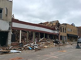
The tornado outbreak of November 30 – December 2, 2018 was a late-season tornado outbreak that occurred across portions of the West South Central states and Midwestern United States. As a potent shortwave trough moved across the southern portions of the country, it was met with ample moisture return and destabilization, resulting in widespread severe thunderstorms that produced damaging winds, hail, and tornadoes. The event began late on November 30 in Oklahoma, spreading east and resulting in one fatality in Aurora, Missouri. Several tornadic supercells moved across portions of Illinois on December 1, and resulted in 29 confirmed tornadoes. This outbreak was the largest December tornado event on record in Illinois history, surpassing the December 1957 tornado outbreak sequence. The most significant tornado of the event was an EF3 that impacted Taylorville, Illinois, damaging or destroying hundreds of structures and injuring 22 people.

On December 15, 2021, a rapidly-deepening low-pressure area contributed to a historic expanse of inclement weather across the Great Plains and Midwestern United States, resulting in an unprecedented December derecho and tornado outbreak across portions of the Northern United States, a region normally affected by snow and cold weather during this time of year. Non-thunderstorm winds spurred the formation of rapidly-moving fires across Colorado and western Kansas, with attendant dust and debris spreading eastward. From central Kansas northeastward into eastern Wisconsin, the powerful derecho led to hundreds of damaging wind reports. At least 57 hurricane-force wind reports were received by the National Weather Service, signaling the most prolific wind event in the United States dating back to at least 2004. Numerous embedded circulations within this rapidly-progressing derecho produced dozens of tornadoes, including 33 that were rated EF2. The culmination of non-thunderstorm, thunderstorm, and tornadic winds caused widespread damage to structures, trees, power lines, and vehicles across the Plains and Midwest. At least 600,000 people lost power on December 15, and temperatures dropped significantly across the affected region following the event, causing accumulating snow, which hindered cleanup and recovery efforts. The storm killed at least 5 people directly, as well as 2 people indirectly through wildfires partly spawned by the storm, and caused at least $1.8 billion in damages. The number of tornadoes in this event broke a record for largest outbreak in the month of December that had been set less than a week prior. The event also became one of the largest single-day outbreaks in recorded history, with 120 tornadoes occurring over an eight-hour period.

A significant early spring tornado outbreak occurred during the afternoon and evening hours of March 5, 2022 in the Midwest, primarily in the state of Iowa, before transitioning to a damaging wind event across northern parts of Illinois and Indiana. Multiple tornadoes were reported, several of which were produced by a dominant supercell thunderstorm in central Iowa. One long-track, low-end EF4 tornado caused major damage near the towns of Winterset and Norwalk, resulting in six fatalities. Multiple other supercells spawned along an area of moderate destabilization in northern Missouri, prompting further tornado warnings in southern Iowa, as they entered a highly favorable environment for maturing. Large hail and damaging wind gusts accompanied the storms, which continued their passage across the Midwestern states into overnight. More tornadic weather was confirmed in Arkansas and Missouri the next day and into the early morning of March 7. In addition to that, straight line winds killed one person near Hazel, Kentucky when a semi trailer was blown over on US 641. Another non-tornadic fatality occurred in western New York as the storm approached.

The April 2022 North American storm complex affected much of the Rocky Mountains and the Midwestern United States with tornadoes, heavy snow, and gusty winds. The system in general first began impacting the Northwest on April 11, before moving eastward into the Rocky Mountains the following day. It was also responsible for producing a large severe weather outbreak of tornadoes and damaging straight-line wind in the Midwest and South while contributing to a powerful blizzard in the upper Midwest states of North and South Dakota.