Virginia is a city in St. Louis County, Minnesota, United States, on the Mesabi Iron Range. With an economy heavily reliant on large-scale iron ore mining, Virginia is considered the Mesabi Range's commercial center. The population was 8,423 people at the 2020 census. Virginia is a part of the Duluth metropolitan area, and U.S. Highway 53 runs through town.

Stephens City is an incorporated town in the southern part of Frederick County, Virginia, United States, with a population of 2,016 at the time of the 2020 census, and an estimated population of 2,096 in 2022. Founded by Peter Stephens in the 1730s, the colonial town was chartered and named for Lewis Stephens in October 1758. It was originally settled by German Protestants from Heidelberg.

Athens is a town in Mercer County, West Virginia, United States. The population was 944 at the 2020 census. It is part of the Bluefield, WV-VA micropolitan area which has a population of 107,578. Athens is the home of Concord University.
Piedmont is a town in Mineral County, West Virginia, United States. It is part of the Cumberland, MD-WV metropolitan statistical area. The population was 716 at the 2020 census. Piedmont was chartered in 1856 and the town is the subject of Colored People: A Memoir by Piedmont native Henry Louis Gates Jr.
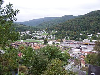
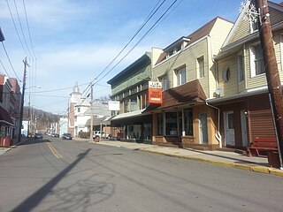
Richwood is a city in Nicholas County, West Virginia, United States. In 2020, the census showed Richwood with a population of 1,661. During the 19th and early 20th century Richwood was a booming coal and lumber town. Richwood has a very rich history, including the formation of the Cherry River Navy civic organization to draw attention to issues important to the community. Richwood has also become known statewide as the "Ramp Capital of the World". Each year, in April, the city hosts a large festival that draws visitors from around the country.

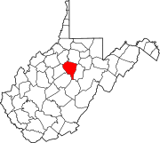
Summersville is a city in Nicholas County, West Virginia, United States. The population was 3,459 at the 2020 census. It is the county seat of Nicholas County.

Sterling, Virginia, refers most specifically to a census-designated place (CDP) in Loudoun County, Virginia, United States. The population of the CDP as of the 2020 United States Census was 30,337 The CDP boundaries are confined to a relatively small area between Virginia State Route 28 on the west and Virginia State Route 7 on the northeast, excluding areas near SR 606 and the Dulles Town Center.
Bloomington is an unincorporated community and census-designated place (CDP) located in southeastern Garrett County, Maryland located at the confluence of the North Branch Potomac River and Savage River. It lies to the west of Luke on Maryland Route 135 and is bounded to the northwest by Savage River State Forest. As of the 2010 census the population of Bloomington was 305.

Mount Storm is an unincorporated community in Grant County, West Virginia, United States. Mount Storm lies on the Northwestern Turnpike at its junction with West Virginia Route 42. The community is the site of the Union School Complex, which contains Union High School.
Mathias is an unincorporated community along the Lost River in Hardy County in the U.S. state of West Virginia. Mathias lies off West Virginia Route 259. Before the consolidated school of East Hardy High School at Baker, Mathias had its own educational facility, Mathias School, which served grades kindergarten through twelfth.

Elkhorn is an unincorporated community in McDowell County, West Virginia, United States. Elkhorn lies on U.S. Route 52 and takes its name from the creek that flows through the community.
Sandyville is an unincorporated community in north central Jackson County, West Virginia, United States. It lies close to the left fork of Sandy Creek, nestled in the hills between Ravenswood and Ripley. It has a population of 1,721 and an average household income of $41,122.
Hacker Valley is an unincorporated community in northern Webster County, West Virginia, United States, along the Left Fork of the Holly River. Its ZIP Code is 26222.
Belva is an unincorporated community and census-designated place in west Nicholas County and north Fayette County, West Virginia, United States; while the CDP only includes the Nicholas County portion, the Fayette County portion is considered part of the community. The town is situated at the bottomland surrounding the convergence of Bells Creek with Twentymile Creek and, subsequently, Twenty Mile Creek with the Gauley River. Belva is also the location of the convergence of two state highways: West Virginia Route 16 and West Virginia Route 39.
Neola is an unincorporated community in northeastern Greenbrier County, West Virginia, United States. It lies along West Virginia Route 92 north of the city of White Sulphur Springs. Its elevation is 2,037 feet (621 m).
Rock View is an unincorporated community in Wyoming County, West Virginia, United States.
Pickens is a census-designated place (CDP) in Randolph County, West Virginia, United States. Pickens is 13 miles (21 km) west-southwest of Huttonsville. It is the home of the Cunningham-Roberts Museum. Pickens has a post office with ZIP code 26230. As of the 2010 census, its population was 66.
Frost is an unincorporated community in eastern Pocahontas County, West Virginia, United States. Frost is also home to Mountain Quest Institute.
Procious is an unincorporated community in Clay County, West Virginia, United States. Procious is located on the Elk River and West Virginia Route 4, 7 miles (11 km) west-northwest of Clay. Procious has a post office with ZIP code 25164.

Declan Rice is an English professional footballer who plays as a defensive midfielder for Premier League club Arsenal and the England national team. Known for his stamina, strength, ball carrying ability and tackling, he is regarded as one of the best defensive midfielders in the world.