Iroquois Point, Hawaii

Last updated
Iroquois Point
Honolulu County Hawaii Incorporated and Unincorporated areas Iroquois Point Highlighted.svg
Location in Honolulu County and the state of Hawaii
Coordinates: 21°19′46″N157°58′51″W / 21.32944°N 157.98083°W / 21.32944; -157.98083 Coordinates: 21°19′46″N157°58′51″W / 21.32944°N 157.98083°W / 21.32944; -157.98083
Country United States
State Hawaii
Area
[1]
  Total1.15 sq mi (2.96 km2)
  Land0.81 sq mi (2.11 km2)
  Water0.33 sq mi (0.86 km2)
Elevation
11 ft (3 m)
Population
 (2020)
  Total4,549
  Density5,595.33/sq mi (2,160.76/km2)
Time zone UTC-10 (Hawaii-Aleutian)
ZIP code
96706 [2]
Area code 808
FIPS code 15-19100
Pu`uloa Lagoon in the center of Iroquois Point Housing Puuloa Lagoon.jpg
Puʻuloa Lagoon in the center of Iroquois Point Housing

Iroquois Point is a census-designated place (CDP) in Honolulu County, Hawaii, United States, on the island of Oahu near Pearl Harbor. The population was 4,549 at the 2020 census. "Iroquois Point" refers to the geographic land area that is occupied by the Kapilina Beach Homes (known as "Waterfront at Pu'uloa" until 2015 and "Iroquois Point Island Club" prior to 2008), a firing range, a Navy Exchange shoppette and gas station, and Iroquois Point Elementary School. Once primarily used as a military housing community, it is now privately operated.

Contents

Geography

Iroquois Point is located at 21°19'46" north, 157°58'51" west (21.329350, -157.980963). [3] It is reached from North Road in ʻEwa Beach by turning onto Iroquois Drive. Alternatively, Iroquois Point Road from Fort Weaver Road in ʻEwa to West Loch Drive, and West Loch Drive south connecting to the end of North Road just beyond Iroquois Drive.

According to the United States Census Bureau, the CDP has a total area of 0.6 square miles (1.6 km2), of which 0.5 square miles (1.3 km2) is land and 0.1 square miles (0.26 km2) is water. The total area is 15.62% water.

Demographics

Historical population
CensusPop.
2020 4,549
U.S. Decennial Census [4]

As of the census [5] of 2000, there were 2,462 people, 675 households, and 660 families residing in the CDP. The population density was 4,585.0 inhabitants per square mile (1,770.3/km2). There were 1,035 housing units at an average density of 1,927.5 per square mile (744.2/km2). The racial makeup of the CDP was 76.81% White, 5.56% African American, 1.06% Native American, 4.14% Asian, 0.89% Pacific Islander, 4.10% from other races, and 7.43% from two or more races. 7.88% of the population were Hispanic or Latino of any race.

There were 675 households, out of which 83.6% had children under the age of 18 living with them, 95.0% were married couples living together, 1.9% had a female householder with no husband present, and 2.2% were non-families. 1.9% of all households were made up of individuals, and 0.0% had someone living alone who was 65 years of age or older. The average household size was 3.65 and the average family size was 3.68.

In the CDP the population was spread out, with 44.5% under the age of 18, 4.8% from 18 to 24, 48.1% from 25 to 44, 2.6% from 45 to 64, and 0.1% who were 65 years of age or older. The median age was 26 years. For every 100 females, there were 105.2 males. For every 100 females age 18 and over, there were 100.1 males.

The median income for a household in the CDP was $44,200, and the median income for a family was $44,200. Males had a median income of $33,590 versus $26,458 for females. The per capita income for the CDP was $13,257. 1.8% of the population and 2.5% of families were below the poverty line. Out of the total population, 1.7% of those under the age of 18 and 0.0% of those 65 and older were living below the poverty line.

History

The name of Iroquois Point was derived from the name USS Iroquois which was held by two U.S. Navy ships. Both ships had history that related to that spot at the entrance to Pearl Harbor. USS Iroquois, a steam sloop of war commissioned in 1850, was outfitted as a hospital ship to provide care to U.S. sailors aboard vessels anchored in Honolulu Harbor, and it is believed that the ship was anchored near the present Iroquois Point site. The second USS Iroquois, a commercial steam tug commissioned in 1898, was assigned to Commander F. Merry as part of his operations at Naval Station Honolulu. [6]

During WWII the Seabees built a Seabee encampment of four 1000 man Construction Battalion areas at Iroquois Point with a chapel. [7] They also built an Advance Base Reshipment Depot (ABRD) and an Advance Base Construction Depot (ABCD). [7] Construction Battalion Maintenance Unit 523 was stationed at the ABRD. [8]

Iroquois Point also had an annex to the Bishop point Section Station and Net Depot [9] across the harbor channel. The annex had a barracks, officer's quarters and 600' of pier.

Starting in the summer of 2003 this U.S. Navy property was leased to Hunt Building Co. and Fluor Federal Services LLCa joint venture now operating as Ford Island Propertiesin exchange for in-kind construction and infrastructure repairs on Ford Island. This unprecedented arrangement was made possible through special legislation passed by Congress in 1999. The Navy gave the developers a 65-year lease of Iroquois Point/Puʻuloa, a 34-acre (14 ha) parcel on Ford Island, and the 6.6-acre (2.7 ha) Hālawa Landing all underutilized Navy properties. The developers also were allowed to purchase 695 acres (2.81 km2) of housing at Kalaeloa after three years and given outright ownership of the 515-acre (2.08 km2) former Waikele Naval Magazine (Gordon, 2005).

Built in the 1960s, the homes on the north side of Puʻuloa Lagoon were empty when renovations began in August 2003, with more than 100 tradesmen working on a daily basis, moving block by block through the housing development. Something less than half of the 1,463 homes were upgraded with an initial investment of about $20 million. Beyond that, several million dollars is to be invested for amenities, such as a community center (Gordon, 2005). Iroquois Point housing lies directly under the glideslope of runway 8L of Honolulu International Airport. Neighborhood residents are often witness to large commercial and military jets that land at the airport flying low over the area.

Education

Hawaii Department of Education operates public schools. Iroquois Point Elementary School is in the area though it is outside the CDP and has an Ewa Beach postal address. [10] [11]

Related Research Articles

<span class="mw-page-title-main">Aiea, Hawaii</span> Census-designated place in Hawaii, United States

Aiea is a census-designated place (CDP) located in the City and County of Honolulu, Hawaii, United States. As of the 2010 Census, the CDP had a total population of 9,338.

<span class="mw-page-title-main">Kalaeloa, Hawaii</span> Census-designated place in Hawaii, United States

Kalaeloa is a census-designated place (CDP) in Honolulu County, Hawaii, United States. The population was 2,364 at the 2020 census. The community occupies the location of the former Naval Air Station Barbers Point, which was closed in 1999 and subsequently transferred to the State of Hawaiʻi. The geographical name, Ka lae loa, means "long point" in Hawaiian and is the native name for what has been called Barbers Point on Oʻahu. The area was known as Barbers Point because Captain Henry Barber wrecked his ship on a coral shoal at this location on October 31, 1796.

<span class="mw-page-title-main">ʻEwa Beach, Hawaii</span> Census-designated place in Hawaii, United States

ʻEwa Beach or simply ʻEwa is a census-designated place (CDP) located in ʻEwa District and the City & County of Honolulu along the coast of Māmala Bay on the leeward side of Oʻahu in Hawaii. As of the 2010 Census, the CDP had a total population of 14,955. The U.S. postal code for ʻEwa Beach is 96706.

<span class="mw-page-title-main">ʻEwa Gentry, Hawaii</span> Census-designated place in Hawaii, United States

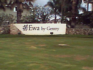
ʻEwa Gentry is a housing development and, as Ewa Gentry, a census-designated place (CDP) located in the ʻEwa District and the City & County of Honolulu on the leeward side of Oʻahu in Hawaiʻi about twelve miles (19 km) from Honolulu. As of the 2010 Census, the CDP had a total population of 22,690.

<span class="mw-page-title-main">ʻEwa Villages, Hawaii</span> Census-designated place in Hawaii, United States

Ewa Villages is a census-designated place (CDP) located in the ʻEwa District and the City & County of Honolulu on the leeward side of Oʻahu in Hawaiʻi approximately 20 miles (32 km) from downtown Honolulu. As of the 2020 census, the CDP had a population of 7,825.

<span class="mw-page-title-main">Halawa, Hawaii</span> Census-designated place in Hawaii, United States

Halawa is a census-designated place (CDP) in the ‘Ewa District of Honolulu County, Hawaii, United States. Halawa Stream branches into two valleys: North and South Halawa; North Halawa is the larger stream and fluvial feature. Their confluence is within the H-3/H-201 highways exchange. Most of Halawa Valley is undeveloped. As of the 2020 census, the CDP had a population of 15,016.

<span class="mw-page-title-main">Kahaluʻu, Hawaii</span> Census-designated place in Hawaiʻi, United States

Kahaluʻu is a residential community and census-designated place (CDP) in the City and County of Honolulu, Hawaii, United States, in the District of Koolaupoko on the island of Oahu. In Hawaiian ka haluʻu means "diving place". As of the 2020 census, the CDP had a total population of 5,241.

<span class="mw-page-title-main">Kahuku, Hawaii</span> Census-designated place in Hawaii, United States

Kahuku is a census-designated place (CDP) in Honolulu, Hawaii, United States. In the Hawaiian language, ka huku means "the projection", presumably a reference to Kahuku Point nearby, the northernmost point of land on the island of Oahu. As of the 2010 Census, Kahuku had a population of 2,614.

<span class="mw-page-title-main">Makakilo, Hawaii</span> Census-designated place in Hawaii, United States

Makakilo or Makakilo City is a census-designated place and residential area located in the ʻEwa District on the island of Oʻahu in the City & County of Honolulu, United States. In Hawaiian, maka kilo means "observing eyes". As of the 2020 census, the CDP had a population of 19,877.

<span class="mw-page-title-main">Mokulēia, Hawaii</span> Census-designated place in Hawaii, United States

Mokulēʻia is a North Shore community and census-designated place (CDP) in the Waialua District on the island of Oʻahu, City & County of Honolulu, Hawaiʻi, United States. Mokulēʻia means "isle (of) abundance" in Hawaiian. As of the 2020 census, the CDP had a population of 1,816. Features of interest here include Mokulēʻia Beach, Mokulēʻia Polo Field, and Dillingham Airfield located west of the town.

<span class="mw-page-title-main">Pearl City, Hawaii</span> Census-designated place in Hawaii, United States

Pearl City is an unincorporated community and census-designated place (CDP) located in the ʻEwa District and City & County of Honolulu on the Island of Oʻahu. As of the 2010 Census, the CDP had a total population of 47,698. Pearl City is located along the north shore of Pearl Harbor. Waimalu borders Pearl City to the east, while Waipahu borders the west. The U.S. postal code for Pearl City is 96782.

<span class="mw-page-title-main">Wahiawa, Hawaii</span> Census-designated place in Hawaii, United States

Wahiawa is a census-designated place (CDP) in Honolulu County, Hawaii, United States, on the island of Oahu. It is in the Wahiawa District, on the plateau or "central valley" between the two volcanic mountains that comprise the island. In Hawaiian, wahi a wā means "place of the wa people". The population was 18,658 at the 2020 census.

<span class="mw-page-title-main">Waimalu, Hawaii</span> Census-designated place in Hawaii, United States

Waimalu is a census-designated place (CDP) in Honolulu County, Hawaiʻi, United States. The population was 13,817 at the 2020 census.

<span class="mw-page-title-main">Waimanalo Beach, Hawaii</span> Census-designated place in the United States

Waimānalo Beach is a census-designated place (CDP) located in the City & County of Honolulu, in the District of Koʻolaupoko, on the island of Oʻahu in the U.S. state of Hawaiʻi. This small windward community is located near the eastern end of the island, and the climate is dry. As of the 2020 census, the CDP had a population of 4,823. This neighborhood is close to, but somewhat separate from Waimānalo, although the two form a single community.

<span class="mw-page-title-main">Waipahu, Hawaii</span> Census-designated place in Hawaii, United States

Waipahu is a former sugarcane plantation town and now census-designated place (CDP) located in the ʻEwa District on the island of Oʻahu in the City & County of Honolulu, Hawaiʻi, United States. As of the 2020 census, the CDP population was 43,485. The U.S. postal code for Waipahu is 96797.

<span class="mw-page-title-main">Waipio, Hawaii</span> Census-designated place in Hawaii, United States

Waipiʻo is a census-designated place (CDP) located in the Ewa District of the island of Oʻahu in the City & County of Honolulu, Hawaii, United States. In Hawaiian, wai piʻo means "curved water". As of the 2020 census, the CDP had a population of 12,082.

<span class="mw-page-title-main">Maalaea, Hawaii</span> Census-designated place in Hawaii, United States

Maalaea is a census-designated place (CDP) in Maui County, Hawaii, United States. The population was 310 at the 2020 census. Maalaea is the site of a small boat harbor, as well as the Maui Ocean Center, and a Shinto shrine, as well as being the historical location for the original Maui Airport.

<span class="mw-page-title-main">Channel Islands Beach, California</span> Place in California, United States

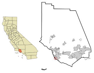
Channel Islands Beach is an unincorporated community in Ventura County, California, United States consisting of three historic neighborhoods: Hollywood Beach, Hollywood by the Sea, and Silver Strand Beach. This densely populated narrow 1.3-mile-long strip (2.1 km) along the coastal edge of the Oxnard Plain was subdivided using the glamor of Hollywood to sell lots in the mid 1920s since the sand dunes had been used for movies. Adjacent development has left this sandy beachfront neighborhood hemmed in by Channel Islands Harbor and Naval Base Ventura County. The harbor mouth separates them into two communities resulting in a round-about travel route around the harbor between them although the Channel Islands Beach Community Services District provides local utilities services to the entire neighborhood. The Special-purpose district has an elected Board of Directors which provides a forum for the unique concerns of the community. Lying immediately adjacent but outside the corporate boundaries of the City of Oxnard and the City of Port Hueneme, they are governed by the county Board of Supervisors.

<span class="mw-page-title-main">Hickam Housing, Hawaii</span> Census-designated place in Hawaii, United States

Hickam Housing is a census-designated place comprising part of Joint Base Pearl Harbor–Hickam in the City & County of Honolulu, Hawaii, United States. The population was 7,581 at the 2020 census. The CDP occupies the area that was formerly Hickam Air Force Base.

<span class="mw-page-title-main">Ocean Pointe, Hawaii</span> Census-designated place in the United States

Ocean Pointe is a housing development and a census-designated place (CDP) located in the ʻEwa District and the City & County of Honolulu on the leeward side of Oʻahu in Hawaiʻi about fifteen miles (24 km) from Honolulu. As of the 2010 Census, the CDP had a total population of 8,361. This general area was previously known just as ʻEwa. In the late 19th century to early 20th century, ʻEwa was one of the large population centers on the Island of Oʻahu, with industry focused around sugar cane production. The ʻEwa Mill was a major employer that set up residential villages. Sugar cane is no longer grown on the ʻEwa Plain and Ocean Pointe is now part of Oʻahu's new suburban growth center—an area of substantial sprawl spreading unbroken to the south to ʻEwa Beach, north to Honouliuli, and west to Kalaeloa and Kapolei. This area is now referred to as Oʻahu's Second City, with a city center (downtown) located in Kapolei.

References

  1. "2020 U.S. Gazetteer Files". United States Census Bureau. Retrieved December 18, 2021.
  2. "Iroquois Point HI ZIP Code". zipdatamaps.com. 2023. Retrieved January 26, 2023.
  3. "US Gazetteer files: 2010, 2000, and 1990". United States Census Bureau. 2011-02-12. Retrieved 2011-04-23.
  4. "Census of Population and Housing". Census.gov. Retrieved June 4, 2016.
  5. "U.S. Census website". United States Census Bureau . Retrieved 2008-01-31.
  6. Hommon, Becky (August 2005). "Hawaii Navy News: Life & Leisure" (PDF).
  7. 1 2 136th Seabee cruisebook, 135th CB, Yokouska, Japan, Oct 1945, Seabee Museum Archives, Port Hueneme, CA
  8. CBMU 523 History file, Seabee Museum Archives, Port Hueneme, CA
  9. Bishop Point and Iroquois Point, Building the Navy's Bases in WWII, History of BuDocks and the Civil Engineer Corps, Vol 1, GPO Washington DC, 1947, p.128
  10. "Home". Iroquois Point Elementary School. Retrieved 2020-10-09. 5553 Cormorant Avenue, Ewa Beach, HI 96706
  11. 2010 Map: "2010 CENSUS - CENSUS BLOCK MAP: Iroquois Point CDP, HI" (PDF). U.S. Census Bureau . Retrieved 2020-10-09.
    2000 map: "CENSUS 2000 BLOCK MAP: IROQUOIS POINT CDP" (PDF). U.S. Census Bureau . Retrieved 2020-10-09.