Honolulu is the capital and most populous city of the U.S. state of Hawaii, which is in the Pacific Ocean. An unincorporated city, it is the county seat of the consolidated City and County of Honolulu, situated along the southeast coast of the island of Oʻahu, and is the westernmost and southernmost major U.S. city. Honolulu is Hawaii's main gateway to the world. It is also a major hub for business, finance, hospitality, and military defense in both the state and Oceania. The city is characterized by a mix of various Asian, Western, and Pacific cultures, reflected in its diverse demography, cuisine, and traditions.

ʻAiea is a census-designated place (CDP) located in the City and County of Honolulu, Hawaii, United States. As of the 2010 Census, the CDP had a total population of 9,338.

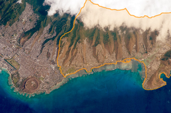
Kailua is a census-designated place (CDP) in Honolulu County, Hawaii, United States. It lies in the Koʻolaupoko District of the island of Oʻahu on the windward coast at Kailua Bay. It is in the judicial district and the ahupua'a named Ko'olaupoko. It is 12 miles (19 km) northeast of Honolulu – over Nu‘uanu Pali.
Kaneohe or Kāneʻohe is a census-designated place (CDP) included in the City and County of Honolulu and in Hawaiʻi state District of Koʻolaupoko on the island of Oʻahu. In the Hawaiian language, kāne ʻohe means "bamboo man". According to an ancient Hawaiian story, a local woman compared her husband's cruelty to the sharp edge of cutting bamboo; thus the place was named Kāneʻohe or "bamboo man".

Maunawili is a residential census-designated place (CDP) in the City & County of Honolulu, Koʻolaupoko District, Island of Oʻahu, Hawaii, United States. As of the 2020 census, the CDP had a population of 2,026. Situated mauka of Kalanianaʻole Highway between Castle Junction and Castle Hospital, Maunawili is nearly all private homes, schools, and a few churches; horse stables complete the rural setting. There are no commercial establishments. However, residents are only minutes from Kailua.
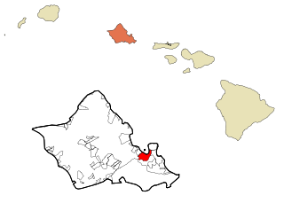
Pearl City is an unincorporated community and census-designated place (CDP) in the ʻEwa District and City & County of Honolulu on the island of Oʻahu. As of the 2010 census, the CDP had a population of 47,698. Pearl City sits along the north shore of Pearl Harbor. Waimalu borders Pearl City to the east and Waipahu borders the west. The U.S. postal code for Pearl City is 96782.

Schofield Barracks is a United States Army installation and census-designated place (CDP) located in Honolulu and in the Wahiawa District of the Hawaiian island of Oʻahu, Hawaiʻi. Schofield Barracks lies adjacent to the town of Wahiawā, separated from most of it by Lake Wilson. Schofield Barracks is named after Lieutenant General John McAllister Schofield, who was the Commanding General of the United States Army from August 1888 to September 1895. He had been sent to Hawaiʻi in 1872 and had recommended the establishment of a naval base at Pearl Harbor.
Wahiawa is a census-designated place (CDP) in Honolulu County, Hawaii, United States, on the island of Oahu. It is in the Wahiawā District, on the plateau or "central valley" between the two volcanic mountains that bookend the island. In Hawaiian, wahi a wā means "place of the wa people". The population was 18,658 at the 2020 census.

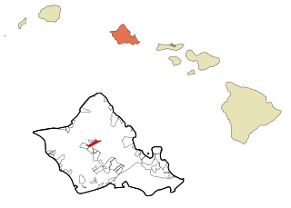
Waimalu is a census-designated place (CDP) in Honolulu County, Hawaiʻi, United States. The population was 13,817 at the 2020 census.

Waimānalo is a census-designated place (CDP) in the District of Koʻolaupoko, in the City & County of Honolulu, on the island of Oʻahu, Hawaii, United States. This small windward community is located near the eastern end of the island. In the Hawaiian language Waimānalo means "potable water"; it is so named for the many brackish ponds in the area that were used for irrigation. As of the 2020 census, the CDP had a population of 6,057.

Waimānalo Beach is a census-designated place (CDP) located in the City & County of Honolulu, in the District of Koʻolaupoko, on the island of Oʻahu in the U.S. state of Hawaiʻi. This small windward community is located near the eastern end of the island, and the climate is dry. As of the 2020 census, the CDP had a population of 4,823. This neighborhood is close to, but somewhat separate from Waimānalo, although the two form a single community.

Hickam Housing is a census-designated place comprising part of Joint Base Pearl Harbor–Hickam in the City & County of Honolulu, Hawaii, United States. The population was 7,581 at the 2020 census. The CDP occupies the area is also referred to as Hickam Air Force Base.

Hawaiʻi Kai, also known as Maunalua or Koko Marina, is a largely residential area located in the City & County of Honolulu, in the East Honolulu CDP, on the island of Oʻahu. Hawaiʻi Kai is the largest of several communities at the eastern end of the island. The area was largely developed by Henry J. Kaiser around the ancient Maunalua fishpond and wetlands area known as Kuapā. Hawaiʻi Kai or Koko Marina was dredged from Kuapā Pond starting around 1959. Dredging not only transformed the shallow coastal inlet and wetlands into a marine embayment, but was accompanied by considerable filling and clearing of the pond margins. In 1961, Kaiser-Aetna entered into a lease agreement with the land owner, the Bernice Pauahi Bishop Estate, to develop the 521 acre (2.11 km2) fishpond into residential tracts with a marina and channels separated by fingers of land and islands upon which house lots and commercial properties would be laid out and developed. Nearly all of the low-lying lands surrounding the marina have since been developed, and neighborhoods now extend back into the several valleys and up the separating ridges.
ʻĀina Haina is an unincorporated town of the City & County of Honolulu in the state of Hawaiʻi of the United States. Located on the island of Oʻahu, ʻĀina Haina is a residential community developed around Kalanianaole Highway east of Waikīkī and Diamond Head. ʻĀina Haina was named after local dairyman and owner of Hind-Clarke Dairy, Robert Hind. ʻĀina Haina in the Hawaiian language means "Hind's Land". A main street is a loop named Hind Drive for him. ʻĀina Haina has two elementary schools and a shopping center.
Waialae Country Club is a private country club in East Honolulu, Hawaii. Founded 97 years ago in 1927 and designed by Seth Raynor, it is a par 72 championship course at 7,125 yards (6,515 m) from the Championship tees. From the Members tees at 6,456 yards (5,903 m), the course rating is 71.8 with a slope rating of 136.

Henry J. Kaiser High School is a WASC-accredited, four-year public high school located in the U.S. state of Hawaiʻi in the East Honolulu community of Hawaiʻi Kai.
Kalani High School is a four-year public high school located in East Honolulu, Hawaiʻi, USA. Kalani is a part of the Hawaii Department of Education. Kalani is located on Kalanianaʻole Highway. It is accredited by the Western Association of Schools and Colleges.
Honolulu Waldorf School, established in 1961, is a coeducational, independent school serving more than 300 children from early childhood through middle school located on the island of Oahu in the State of Hawaii. It previously included high school levels.

Honolulu County, officially known as the City and County of Honolulu, is a consolidated city-county in the U.S. state of Hawaii. The city-county includes both Urban Honolulu and the rest of the neighborhoods on the island of Oʻahu, as well as several minor outlying islands, including all of the Northwestern Hawaiian Islands except Midway Atoll.
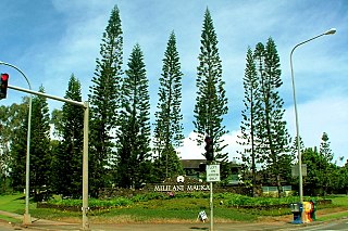
Mililani Mauka is a census-designated place (CDP) in Honolulu County, Hawaii on the island of Oʻahu, Hawaii, United States. As of the 2020 census, the CDP had a population of 21,075.