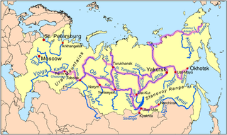
The Irtysh[note 1] is a river in Russia, China, and Kazakhstan. It is the chief tributary of the Ob and is also the longest tributary river in the world.
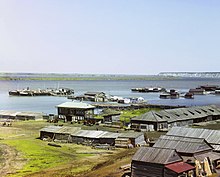
Map including the lower reaches of the Irtysh RiverThe Irtysh in OmskThe Irtysh near Pavlodar in Kazakhstan
From its origins as the Kara-Irtysh (Black Irtysh) in the Mongolian Altay mountains in Xinjiang, China, the Irtysh flows northwest through Lake Zaysan in Kazakhstan, meeting the Ishim and Tobol rivers before merging with the Ob near Khanty-Mansiysk in western Siberia, Russia after 4,248 kilometres (2,640mi).
The name Black Irtysh (Kara-Irtysh in Kazakh, or Cherny Irtysh in Russian) is applied by some authors, especially in Russia and Kazakhstan, to the upper course of the river, from its source entering Lake Zaysan. The term White Irtysh, in opposition to the Black Irtysh, was occasionally used in the past to refer to the Irtysh below lake Zaysan;[3] now this usage is largely obsolete.
Main tributaries
The largest tributaries of the Irtysh are, from source to mouth:
In Kazakhstan and Russia, tankers, passenger ships, and cargo vessels navigate the river during the ice-free season, between April and October. Omsk, home to the headquarters of the state-owned Irtysh River Shipping Company, functions as the largest river port in Western Siberia.
On the Kazakhstan section of the river there are presently three major hydroelectric plants, namely at Bukhtarma, Ust-Kamenogorsk and Shulbinsk. The world's deepest lock, with a drop of 42 metres (138ft), allows river traffic to by-pass the dam at Ust-Kamenogorsk.[4] Plans exist for the construction of several more dams.
The Northern river reversal proposals, widely discussed by the USSR planners and scientists in the 1960s and 1970s, would send some of the Irtysh's (and possibly Ob's) water to the water-deficient regions of central Kazakhstan and Uzbekistan. Some versions of this project would have seen the direction of flow of the Irtysh reversed in its section between the mouth of the Tobol (at Tobolsk) and the confluence of the Irtysh with the Ob at Khanty-Mansiysk, thus creating an "Anti-Irtysh".[7] While these gigantic interbasin transfer schemes were not implemented, a smaller Irtysh–Karaganda Canal was built between 1962 and 1974 to supply water to the dry Kazakh steppes and to one of the country's main industrial center, Karaganda. In 2002, pipelines were constructed to supply water from the canal to the Ishim and Kazakhstan's capital, Nur-Sultan.
In China, a short canal was constructed in 1987 (water intake at 47°26′31″N87°34′11″E / 47.44194°N 87.56972°E / 47.44194; 87.56972) to divert some of the Irtysh water to the endorheicLake Ulungur, whose level had been falling precipitously due to the increasing irrigation use of the lake's main affluent, the Ulungur River.[8] In the last years of the 20th century and the early 2000s, a much more major project, the Irtysh–Karamay–Urümqi Canal was completed. Increased water use in China has caused significant concerns among Kazakh and Russian environmentalists.[9][10] According to a report published by Kazakhstan fishery researchers in 2013, the total Irtysh water use in China is about 3 cubic kilometres (0.7cumi) per year; as a result, only about 2/3 of what would be the river's "natural" flow (6km3 out of 9km3) reach the Kazakh border.[11]
Cities
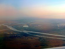
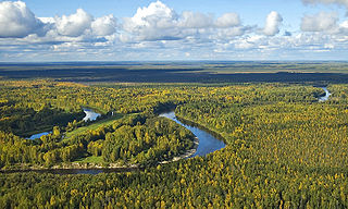
An aerial view of the Irtysh in Omsk
Major cities along the Irtysh, from source to mouth, include:
As the Kuytun–Beitun Railway in China's Xinjiang is being extended toward Altay City, a railway bridge over the Irtysh at Beitun will need to be constructed as well.
Numerous highway bridges over the Irtysh exist in China, Kazakhstan, and Russia.
The last bridge downstream on the Irtysh, a highway bridge opened in 2004, can be found at Khanty-Mansiysk, right before the river's confluence with Ob.
In the 15th and 16th centuries the lower and middle courses of the Irtysh lay within the Tatar Khanate of Sibir; its capital, Qashliq (also known as Sibir) was located on the Irtysh a few kilometres upstream from the mouth of the Tobol (where today's Tobolsk is situated).
The Khanate of Sibir was conquered by the Russians in the 1580s. The Russians started building fortresses and towns next to the sites of former Tatar towns; one of the first Russian towns in Siberia (after Tyumen) was Tobolsk, founded in 1587 at the fall of the Tobol into the Irtysh, downstream from the former Qashliq.[14] Farther east, Tara was founded in 1594, roughly at the border of the taiga belt (to the north) and the steppe to the south.[15]
In the 17th century the Dzungar Khanate, formed by the Mongol Oirat people, became Russia's southern neighbor, and controlled the upper Irtysh.[16] As a result of Russia's confrontation with the Dzungars in the Peter the Great's era,[17] the Russians founded the cities of Omsk in 1716, Semipalatinsk in 1718, Ust-Kamenogorsk in 1720, and Petropavlovsk in 1752.
The Chinese Qing EmpireconqueredDzungaria in the 1750s. This prompted an increase in the Russian authorities' attention to their borderland; in 1756, the Orenburg Governor Ivan Neplyuyev even proposed the annexation of the Lake Zaysan region, but this project was forestalled by Chinese successes.[18] Concerns were raised in Russia (1759) about the (theoretical) possibility of a Chinese fleet sailing from Lake Zaysan down the Irtysh and into Western Siberia. A Russian expedition visited Lake Zaysan in 1764, and concluded that such a riverine invasion would not be likely. Nonetheless, a chain of Russian pickets was established on the Bukhtarma River, north of Lake Zaysan.[19] Thus the border between the two empires in the Irtysh basin became roughly delineated, with a (sparse) chain of guard posts on both sides.
The situation in the borderlands in the mid-19th century is described in a report by A. Abramof (ru; 1865). Even though the Zaysan region was recognized by both parties as part of the Qing empire, it had been annually used, by fishing expeditions sent by the Siberian Cossack Host. The summer expeditions started in 1803, and in 1822–25 their range was expanded through the entire Lake Zaysan and to the mouth of the Black Irtysh. Through the mid-19th century, the Qing presence on the upper Irtysh was mostly limited to the annual visit of the Qing amban from Chuguchak to one of the Cossacks' fishing stations (Batavski Piket).[20]
The border between the Russian and the Qing empires in the Irtysh basin was established along the line fairly similar to China's modern border with Russia and Kazakhstan by the Convention of Peking of 1860.[21] The actual border line pursuant to the convention was drawn by the Protocol of Chuguchak (1864), leaving Lake Zaysan on the Russian side.[22][23] The Qing empire's military presence in the Irtysh basin crumbled during the 1862–77 Dungan Revolt. After the fall of the rebellion and the reconquest of Xinjiang by Zuo Zongtang, the border between the Russian and the Qing empires in the Irtysh basin was further slightly readjusted, in Russia's favor, by the Treaty of Saint Petersburg (1881).
Cultural references
The Irtysh River serves as a backdrop in the epilogue of Fyodor Dostoyevsky's 1866 novel Crime and Punishment. In Aleksandr Solzhenitsyn's The GULAG Archipelago, the chapter "The White Kitten" details Georgi Tenno's escape from a camp along this river.
↑ Skornyakova, V. A.; Timasheva, I. Ye. (1980), "The possible environmental impact of the anti-Irtysh and problems of rational nature management", Soviet Geography, 21 (10): 638–644, doi:10.1080/00385417.1980.10640361
↑ Petr, T., ed. (1999), Fish and Fisheries at Higher Altitudes: Asia, Issue 385 of FAO fisheries technical paper, ISSN 0429-9345, Food & Agriculture Org., p.257, ISBN978-9251043097 (An English translation of the original paper published in the Vestnik Moskovskogo Universiteta in 1979).
The Ob is a major river in Russia. It is in western Siberia, and with its tributary the Irtysh forms the world's seventh-longest river system, at 5,410 kilometres (3,360 mi). The Ob forms at the confluence of the Biya and Katun which have their origins in the Altai Mountains. It is the westernmost of the three great Siberian rivers that flow into the Arctic Ocean. Its flow is north-westward, then northward.
Omsk is the administrative center and largest city of Omsk Oblast, Russia. It is situated in southwestern Siberia and has a population of over 1.1 million. Omsk is the third largest city in Siberia after Novosibirsk and Krasnoyarsk, and the twelfth-largest city in Russia. It is an important transport node, serving as a train station for the Trans-Siberian Railway and as a staging post for the Irtysh River.
Lake Zaysan or Zaisan, also known by other names in other languages, is a freshwater lake in Tarbagatay District, East Kazakhstan Region, Kazakhstan. It is the largest lake in the region. The lake is generally frozen from the beginning of November to the end of April, but still has an abundance of fish.
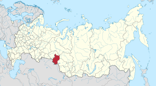
Omsk Oblast is a federal subject of Russia, located in southwestern Siberia. The oblast has an area of 139,700 square kilometers (53,900 sq mi). Its population is 1,977,665 with the majority, 1.12 million, living in Omsk, the administrative center.
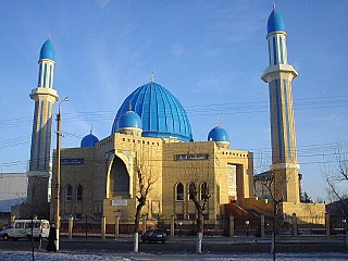
Petropavl ; Russian: Петропавловск, romanized: Petropavlovsk) is a city on the Ishim River in northern Kazakhstan close to the border with Russia. It is the capital of the North Kazakhstan Region. Population: 218,956. The city is also known colloquially in Kazakh as Qyzyljar.
Tobolsk is a town in Tyumen Oblast, Russia, located at the confluence of the Tobol and Irtysh rivers. Founded in 1590, Tobolsk is the second-oldest Russian settlement east of the Ural Mountains in Asian Russia, and was the historic capital of the Siberia region. Population: 100,352 (2021 Census); 99,694 (2010 Census); 92,880 (2002 Census); 94,143 (1989 Census).
The Tobol is a river in Western Siberia and the main (left) tributary of the Irtysh. Its length is 1,591 km (989 mi), and the area of its drainage basin is 426,000 km2 (164,000 sq mi).
Tyumen Oblast is a federal subject of Russia. It is located in Western Siberia, and is administratively part of the Urals Federal District. The oblast has administrative jurisdiction over two autonomous okrugs: Khanty-Mansi Autonomous Okrug and Yamalo-Nenets Autonomous Okrug. Tyumen Oblast, including its autonomous okrugs, is the third-largest federal subject by area, and has a population of 3,395,755 (2010).
The West Siberian Plain is a large plain that occupies the western portion of Siberia, between the Ural Mountains in the west and the Yenisei River in the east, and the Altai Mountains on the southeast. Much of the plain is poorly drained and consists of some of the world's largest swamps and floodplains. Important cities include Chelyabinsk, Novosibirsk, Omsk, and Tomsk, as well as Surgut and Nizhnevartovsk.
Kanas Lake is a lake in Altay Prefecture, Xinjiang, China. The lake is located in a valley in the Altai Mountains, near the very northern tip of Xinjiang and the autonomous region's borders with Russia, Kazakhstan and Mongolia. The lake was formed around 200,000 years ago during the Quaternary period as a result of glacier movement. The crescent moon shaped lake has an estimated water storage capacity of 53.8 billion cubic meters, coupled with an average depth of around 120 meters.
Pavlodar Region is a region of Kazakhstan. The population of the region was 742,475 ; and 806,983 .; the latest official estimate was 756,511. Its capital is the city of Pavlodar, which had a population of 360,014 at the start of 2018. Many people, especially Ukrainians, migrated to Pavlodar in Nikita Khrushchev's Virgin Lands Campaign.
Burqin County is a county in Xinjiang, China and is under the administration of the Kazakh autonomous area of Altay Prefecture. It has an area of 10,362 km2 (4,001 sq mi) with a population of 70,000. The postcode is 836600.
Western Siberia or West Siberia is a region in North Asia. It is part of the wider region of Siberia that is mostly located in the Russian Federation, with a Southern part in Kazakhstan. It lies between the Ural region and the Yenisei River, which conventionally divides Siberia into two halves.
FC Irtysh is the name of following football clubs:
Siberian River Routes were the main ways of communication in Russian Siberia before the 1730s, when roads began to be built. The rivers were also of primary importance in the process of Russian conquest and exploration of vast Siberian territories eastwards. Since the three great Siberian rivers, the Ob, the Yenisey, and the Lena all flow into the Arctic Ocean, the aim was to find parts or branches of these rivers that flow approximately east-west and find short portages between them. Since Siberia is relatively flat, portages were usually short. Despite resistance from the Siberian tribes, Russian Cossacks were able to expand from the Urals to the Pacific in only 57 years (1582-1639). These river routes were crucial in the first years of the Siberian fur trade as the furs were easier to transport over water than land. The rivers connected the major fur gathering centers and provided for relatively quick transport between them.
Below is the list of Kazakhstan-related articles.
The China–Kazakhstan border or the Sino-Kazakhstan border, is the international border between the People's Republic of China and the Republic of Kazakhstan. The border line between the two countries has been largely inherited from the border existing between the Soviet Union and the PRC and, earlier, between the Russian Empire and the Qing Empire; however, it has been fully demarcated only in the late 20th and early 21st century. According to the international boundary commissions that have carried out the border demarcation, the border is 1,782.75 km (1,107.75 mi) long.
The Kulunda Steppe or Kulunda Plain is an alluvial plain in Russia and Kazakhstan. It is an important agricultural region in Western Siberia.
Ishim Steppe is a plain in the southern part of Western Siberia, between the Irtysh and Tobol rivers. Administratively it is part of Kurgan, Tyumen, and Omsk oblasts in Russia, and the North Kazakhstan Region in Kazakhstan.
The Kamyshlov Log, is a former river valley of Siberia. Administratively it falls within Omsk Oblast, Siberian Federal District, of the Russian Federation, as well as the North Kazakhstan Region of Kazakhstan.
This page is based on this Wikipedia article Text is available under the CC BY-SA 4.0 license; additional terms may apply. Images, videos and audio are available under their respective licenses.