Istachatta, Florida

Last updated
Istachatta, Florida
Istachatta Library.jpg
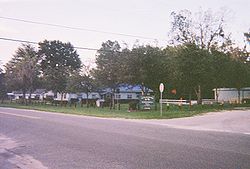
The Istachatta community center and Hernando County Public Library on the corner of CR 439 and Magnon Drive
Hernando County Florida Incorporated and Unincorporated areas Istachatta Highlighted.svg
Location in Hernando County and the state of Florida
Coordinates: 28°39′44″N82°16′37″W / 28.66222°N 82.27694°W / 28.66222; -82.27694 Coordinates: 28°39′44″N82°16′37″W / 28.66222°N 82.27694°W / 28.66222; -82.27694
Country United States
State Florida
County Hernando
Area
[1]
  Total0.35 sq mi (0.91 km2)
  Land0.31 sq mi (0.79 km2)
  Water0.05 sq mi (0.12 km2)
Elevation
59 ft (18 m)
Population
 (2020)
  Total126
  Density411.76/sq mi (158.91/km2)
Time zone UTC-5 (Eastern (EST))
  Summer (DST) UTC-4 (EDT)
ZIP code
34636
Area code(s) 352
FIPS code 12-34275 [2]
GNIS feature ID0284632 [3]

Istachatta is an unincorporated community and census-designated place (CDP) in Hernando County, Florida, United States. The population was 116 at the 2010 census, [4] up from 65 at the 2000 census. The name "Istachatta" is derived from a Seminole word meaning "man snake". [5]

Contents

Geography

Istachatta is in the northeast corner of Hernando County at 28°39′44″N82°16′37″W / 28.66222°N 82.27694°W / 28.66222; -82.27694 (28.662340, -82.276911). [6] It is on the west bank of the Withlacoochee River. It is 11 miles (18 km) northeast of Brooksville, the Hernando County seat, and 14 miles (23 km) south of Inverness.

According to the United States Census Bureau, the CDP has a total area of 0.3 square miles (0.9 km2), of which 0.3 square miles (0.8 km2) are land and 0.04 square miles (0.1 km2), or 13.27%, are water. [4] The town is along the Withlacoochee State Trail, a rail trail that extends north into Citrus and south to Pasco County.

Demographics

Historical population
CensusPop.
2020 126
U.S. Decennial Census [7]

As of the census [2] of 2000, there were 65 people, 34 households, and 22 families residing in the CDP. The population density was 505.4 inhabitants per square mile (195.1/km2). There were 52 housing units at an average density of 404.4 per square mile (156.1/km2). The racial makeup of the CDP was 93.85% White, 4.62% African American, and 1.54% from two or more races. Hispanic or Latino of any race were 3.08% of the population.

There were 34 households, out of which 8.8% had children under the age of 18 living with them, 44.1% were married couples living together, 20.6% had a female householder with no husband present, and 32.4% were non-families. 23.5% of all households were made up of individuals, and 14.7% had someone living alone who was 65 years of age or older. The average household size was 1.91 and the average family size was 2.22.

In the CDP, the population was spread out, with 7.7% under the age of 18, 3.1% from 18 to 24, 9.2% from 25 to 44, 38.5% from 45 to 64, and 41.5% who were 65 years of age or older. The median age was 57 years. For every 100 females, there were 97.0 males. For every 100 females age 18 and over, there were 87.5 males.

The median income for a household in the CDP was $21,250, and the median income for a family was $21,250. Males had a median income of $0 versus $13,750 for females. The per capita income for the CDP was $12,618. There were 33.3% of families and 29.5% of the population living below the poverty line, including 100.0% of under eighteens and none of those over 64.

See also

Related Research Articles

<span class="mw-page-title-main">Citrus Springs, Florida</span> Census-designated place in Florida, US

Citrus Springs is a census-designated place (CDP) in Citrus County, Florida, United States. The population was 8,622 as of the 2010 census, up from 4,157 in 2000.

<span class="mw-page-title-main">Floral City, Florida</span> Census-designated place in Florida, US

Floral City is a census-designated place (CDP) in Citrus County, Florida, United States. The population was 5,216 at the 2010 census. The community is home to the Floral City Heritage Hall Museum and hosts the Floral City Heritage Days the first weekend in December. The area has a history of phosphate mining and includes historic homes.

<span class="mw-page-title-main">Hernando, Florida</span> Census-designated place in Florida, US

Hernando is a census-designated place in Citrus County, Florida, United States. The population was 9,054 at the 2010 census. At one time it was a city but it was disincorporated in the 1970s.

<span class="mw-page-title-main">Inverness Highlands North, Florida</span> Census-designated place in Florida, US

Inverness Highlands North is an unincorporated area and census-designated place (CDP) in Citrus County, Florida, United States. The population was 2,401 at the 2010 census, up from 1,470 in 2000.

<span class="mw-page-title-main">Bayport, Florida</span> Census-designated place in Florida, United States

Bayport is an unincorporated community and census-designated place (CDP) in Hernando County, Florida, United States. The population was 43 at the 2010 census.

<span class="mw-page-title-main">Brookridge, Florida</span> Census-designated place in Florida, United States

Brookridge is a census-designated place (CDP) in Hernando County, Florida, United States. The population was 4,420 at the 2010 census, up from 3,279 at the 2000 census.

<span class="mw-page-title-main">High Point, Hernando County, Florida</span> Census-designated place in Florida, United States

High Point is an unincorporated area and census-designated place (CDP) in Hernando County, Florida, United States. The population was 3,686 at the 2010 census.

<span class="mw-page-title-main">Lake Lindsey, Florida</span> Census-designated place in Florida, United States

Lake Lindsey is an unincorporated community and census-designated place (CDP) in Hernando County, Florida, United States. The population was 71 at the 2010 census.

<span class="mw-page-title-main">Masaryktown, Florida</span> Census-designated place in Florida, United States

Masaryktown is an unincorporated community and census-designated place (CDP) in Hernando County, Florida, United States. The population was 1,077 at the 2020 census. It is named after the first president of Czechoslovakia, Tomáš Garrigue Masaryk.

<span class="mw-page-title-main">Nobleton, Florida</span> Census-designated place in Florida, United States

Nobleton is an unincorporated community and census-designated place (CDP) in Hernando County, Florida, United States. The population was 282 at the 2010 census, up from 160 at the 2000 census.

North Brooksville, Florida Census-designated place in Florida, United States

North Brooksville is a census-designated place (CDP) in Hernando County, Florida, United States. The population was 3,544 at the 2010 census. It is a suburb included in the Tampa-St. Petersburg-Clearwater, Florida Metropolitan Statistical Area.

North Weeki Wachee, Florida Census-designated place in Florida, United States

North Weeki Wachee is a census-designated place (CDP) in Hernando County, Florida, United States. The population was 8,524 at the 2010 census, up from 4,253 at the 2000 census.

Pine Island, Hernando County, Florida Census-designated place in Florida, United States

Pine Island is an unincorporated community and census-designated place (CDP) in Hernando County, Florida, United States. The population was 64 at the 2010 census, unchanged from the 2000 census.

Ridge Manor, Florida Census-designated place in Florida, United States

Ridge Manor is a census-designated place (CDP) in Hernando County, Florida, United States. The population was 4,513 at the 2010 census.

South Brooksville, Florida Census-designated place in Florida, United States

South Brooksville is a census-designated place (CDP) in Hernando County, Florida, United States. The population was 4,007 at the 2010 census. It is a suburb included in the Tampa-St. Petersburg-Clearwater, Florida Metropolitan Statistical Area.

Timber Pines, Florida Census-designated place in Florida, United States

Timber Pines is a census-designated place (CDP) in Hernando County, Florida, United States. The population was 5,386 at the 2010 census.

Weeki Wachee Gardens, Florida Census-designated place in Florida, United States

Weeki Wachee Gardens is a census-designated place (CDP) in Hernando County, Florida, United States. The population was 1,146 at the 2010 census.

University Park, New Mexico Census-designated place in New Mexico, United States

University Park is a census-designated place (CDP) in Doña Ana County, New Mexico, United States. The population was 4,192 at the 2010 census. It is part of the Las Cruces Metropolitan Statistical Area.

Lakeland North, Washington Census-designated place in Washington, United States

Lakeland North is a census-designated place (CDP) in King County, Washington, United States. The population was 12,942 at the 2010 census. Part of the community was annexed into neighboring Auburn in 2008.

Clearview Acres is a census-designated place (CDP) in Sweetwater County, Wyoming, United States. The population was 795 at the 2010 census.

References

  1. "2020 U.S. Gazetteer Files". United States Census Bureau. Retrieved October 31, 2021.
  2. 1 2 "U.S. Census website". United States Census Bureau . Retrieved 2008-01-31.
  3. "US Board on Geographic Names". United States Geological Survey. 2007-10-25. Retrieved 2008-01-31.
  4. 1 2 "Geographic Identifiers: 2010 Demographic Profile Data (G001): Istachatta CDP, Florida". American Factfinder. U.S. Census Bureau. Retrieved April 27, 2017.[ dead link ]
  5. Gannett, Henry (1905). The Origin of Certain Place Names in the United States. Govt. Print. Off. pp.  167.
  6. "US Gazetteer files: 2010, 2000, and 1990". United States Census Bureau. 2011-02-12. Retrieved 2011-04-23.
  7. "Census of Population and Housing". Census.gov. Retrieved June 4, 2016.