
Calvert County is a county located in the U.S. state of Maryland. As of the 2020 census, the population was 92,783. Its county seat is Prince Frederick. The county's name is derived from the family name of the Barons of Baltimore, the proprietors of the English Colony of Maryland. Calvert County is included in the Washington–Arlington–Alexandria, DC–VA–MD–WV Metropolitan Statistical Area. It occupies the Calvert Peninsula, which is bordered on the east by Chesapeake Bay and on the west by the Patuxent River. Calvert County is part of the Southern Maryland region. The county has one of the highest median household incomes in the United States. It is one of the older counties in Maryland, after St. Mary's, Kent County and Anne Arundel counties.

Solomons, also known as Solomons Island, is an unincorporated community and census-designated place (CDP) in Calvert County, Maryland, United States. The population was 2,368 at the 2010 census, up from 1,536 in 2000. Solomons is a popular weekend destination spot in the Baltimore–Washington metropolitan area.

The Patuxent River is a tributary of the Chesapeake Bay in the state of Maryland. There are three main river drainages for central Maryland: the Potomac River to the west passing through Washington, D.C., the Patapsco River to the northeast passing through Baltimore, and the Patuxent River between the two. The 908-square-mile (2,352 km2) Patuxent watershed had a rapidly growing population of 590,769 in 2000. It is the largest and longest river entirely within Maryland, and its watershed is the largest completely within the state.

Southern Maryland is a geographical, cultural and historic region in Maryland composed of the state's southernmost counties on the Western Shore of the Chesapeake Bay. According to the state of Maryland, the region includes all of Calvert, Charles, and St. Mary's counties and the southern portions of Anne Arundel and Prince George's counties. It is largely coterminous with the region of Maryland that is part of the Washington metropolitan area. As of the 2020 Census, the region had a population of 373,177. The largest community in Southern Maryland is Waldorf, with a population of 81,410 as of the 2020 Census.

Maryland Route 4 is a state highway in the U.S. state of Maryland. The highway runs 64.85 miles (104.37 km) from MD 5 in Leonardtown north to Southern Avenue in Suitland at the District of Columbia boundary, beyond which the highway continues into Washington as Pennsylvania Avenue. MD 4 is a four- to six-lane highway that connects Washington and communities around Interstate 95 (I-95)/I-495 with southern Prince George's County with southwestern Anne Arundel County. The highway is the primary highway for the length of Calvert County, during most of which the route runs concurrently with MD 2. MD 4 also connects Calvert and St. Mary's counties via the Governor Thomas Johnson Bridge across the Patuxent River. The highway connects the Southern Maryland county seats of Leonardtown, Prince Frederick, and Upper Marlboro.

The Bollman Truss Railroad Bridge across the Little Patuxent River at Savage, Maryland, is one of the oldest standing iron railroad bridges in the United States and the sole surviving example of a revolutionary design in the history of American bridge engineering. The 160-foot (48.8 m) double-span was built in 1852 at an unknown location on the main line of the Baltimore and Ohio Railroad. It was moved 35 years later to its present location, where it replaced the very first Bollman bridge. Today, it carries the Savage Mill Trail.

The Cedar Point Light was the last house-type lighthouse built in the Chesapeake Bay. An early victim of shoreline erosion, the cupola and gables are preserved at museums.
Broomes Island is a small waterfront community and census-designated place (CDP) located at the southern terminus of MD 264 in Calvert County, Maryland, United States, on the Patuxent River. It is located approximately 10 miles (16 km) south of Prince Frederick, the county seat. As of 2019 Census estimates, the population of the CDP was 421.

The Rudolph Oyster House is a historic seafood processing building on the grounds of the Long Island Maritime Museum in West Sayville, New York. Built in 1908, it is a rare well-preserved example of a typical oyster culling house of the early 20th century, of which many once lined the local waterfront. The building was designated a National Historic Landmark in 2001.

Maryland Route 231 (MD 231) is a state highway in the U.S. state of Maryland. The state highway runs 16.39 miles (26.38 km) from Olivers Shop Road near Hughesville east to MD 765 in Prince Frederick. MD 231 crosses the Patuxent River on the Benedict Bridge, which connects Benedict in eastern Charles County with Hallowing Point in central Calvert County. The highway directly connects MD 5 in Hughesville with MD 2/MD 4 in Prince Frederick. MD 231 was constructed from Hughesville to Benedict and from Hollowing Point to Prince Frederick in the early 1920s. The portion of the state highway west of Hughesville was built in the early 1930s, about the same time ferry service began between Benedict and Hallowing Point. The Benedict Bridge was started in 1950 and was completed in 1952; the bridge remained the southernmost crossing of the Patuxent River for 25 years. The bridge was tolled from its opening until around 1955. MD 231 was reconstructed between Hughesville and Prince Frederick in the mid- to late 1950s to better serve intercounty traffic.

The Chesapeake Bay Maritime Museum is located in St. Michaels, Maryland, United States and is home to a collection of Chesapeake Bay artifacts, exhibitions, and vessels. This 18-acre (73,000 m2) interactive museum was founded in 1965 on Navy Point, once a site of seafood packing houses, docks, and work boats. Today, the museum houses the world's largest collection of Chesapeake Bay boats and provides interactive exhibits in and around the 35 buildings which dot the campus. The museum also offers year-round educational seminars and workshops.

The Calvert Marine Museum is a maritime museum located in Solomons, Maryland.

The William B. Tennison is a Chesapeake Bay bugeye built in 1899 and converted to an oyster buy-boat in 1906–07. With the conversion her sail rig was removed and an engine inserted, and is the only surviving example of this conversion. Her construction marks a transition between log construction and plank construction. She is homeported at the Calvert Marine Museum in Solomons, Maryland. The Tennison is reputed to be the second oldest licensed passenger vessel in the United States.
Sotterley Plantation is a historic landmark plantation house located at 44300 Sotterley Lane in Hollywood, St. Mary's County, Maryland, USA. It is a long 1+1⁄2-story, nine-bay frame building, covered with wide, beaded clapboard siding and wood shingle roof, overlooking the Patuxent River. Also on the property are a sawn-log slave quarters of c. 1830, an 18th-century brick warehouse, and an early-19th-century brick meat house. Farm buildings include an early-19th-century corn crib and an array of barns and work buildings from the early 20th century. Opened to the public in 1961, it was once the home of George Plater (1735–1792), the sixth Governor of Maryland, and Herbert L. Satterlee (1863–1947), a New York business lawyer and son-in-law of J.P. Morgan.

The Saint Michaels Historic District encompasses the historic center of Saint Michaels, Maryland. The town, which has about 1,000 permanent residents, is located on a tributary to the Chesapeake Bay on the Eastern Shore of Maryland. After over 100 years as a center for trade and shipbuilding, the community was incorporated as a town in 1805. Shipbuilding peaked in 1820, and the town's economy became focused more on oyster and seafood collection and packing. In the 1970s, the town transitioned to tourism.

Grahame House, Graham House, Mansion House, Graeme House, or Patuxent Manor, is a historic home located at Lower Marlboro, Calvert County, Maryland. It is an 18th-century original 1+1⁄2-story brick shell laid in Flemish bond with a steeply pitched gable roof. Later alterations have included the purchase and removal of the fine paneling throughout the house to the Winterthur Museum, Garden, and Library.

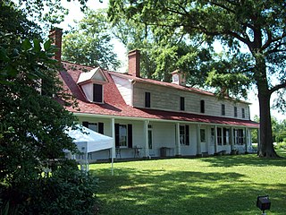
Preston-on-the-Patuxent is a historic home located at Johnstown, Calvert County, Maryland, United States. It is a modest 1+1⁄2-story brick house which has had several later additions made to it. While the home has a traditional construction date of about 1651, there is no structural evidence to indicate a date earlier than about 1725. It has been reported by Puritan knowledge that the original Preston home burned down in 1672, to be replaced by the present structure at a later date. Preston-on-the-Patuxent is popularly, if erroneously, known as the seat of the government of Maryland from 1654 to 1657, during the Puritan regime. The belief that the property was the "capital" comes from evidence that the Council, the Assembly, and the Provincial Court met "at Patuxent" in the 1650s. Richard Preston, a participant in each of the three bodies, most probably hosted their meetings in his dwelling located near the Patuxent River.

Maryland Route 264 is a state highway in the U.S. state of Maryland. Known as Broomes Island Road, the route runs 6.66 miles (10.72 km) from Oyster House Road at Broomes Island north to MD 2/MD 4 in Port Republic. MD 264 connects the central Calvert County communities of Broomes Island, Island Creek, and Mutual with the county's main highway at Port Republic. The state highway was constructed in the early 1920s.


