
The Boston Public Library is a municipal public library system in Boston, Massachusetts, founded in 1848. The Boston Public Library is also the Library for the Commonwealth of the Commonwealth of Massachusetts; all adult residents of the commonwealth are entitled to borrowing and research privileges, and the library receives state funding. The Boston Public Library contains approximately 24 million items, making it the third-largest public library in the United States behind the federal Library of Congress and the New York Public Library, which is also privately endowed. In fiscal year 2014, the library held more than 10,000 programs, all free to the public, and lent 3.7 million materials.

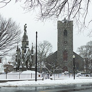
Roxbury is a neighborhood within the City of Boston, Massachusetts.
Jamaica Plain is a neighborhood of 4.4 square miles (11 km2) in Boston, Massachusetts. Settled by Puritans seeking farmland to the south, it was originally part of Roxbury, Massachusetts. The community seceded from Roxbury during the formation of West Roxbury in 1851 and became part of Boston when West Roxbury was annexed in 1874. In the 19th century, Jamaica Plain became one of the first streetcar suburbs in America and home to a significant portion of Boston's Emerald Necklace of parks, designed by Frederick Law Olmsted.

West Roxbury is a neighborhood in Boston, Massachusetts bordered by Roslindale and Jamaica Plain to the northeast, the town of Brookline to the north, the city of Newton to the northwest and the towns of Dedham and Needham to the southwest. West Roxbury is often mistakenly confused with Roxbury, but, by around 6 miles, the two are not connected. West Roxbury is separated from Roxbury by Jamaica Plain and Roslindale.

Roslindale is a primarily residential neighborhood of Boston, Massachusetts, bordered by Jamaica Plain, Hyde Park, West Roxbury and Mattapan. It is served by an MBTA Commuter Rail line, several MBTA bus lines and the MBTA Orange Line in nearby Jamaica Plain. Roslindale has its own branch of the Boston Public Library, the neighborhood is covered by Boston Police District E-5 in West Roxbury, Boston EMS Ambulance 17 is stationed in Roslindale, and the Boston Fire Department has a station on Canterbury Street which houses Ladder 16, Engine 53 & District Chief 12. Roslindale's original Engine Company 45, was deactivated on April 10, 1981, due to budget cuts. Roslindale was once called the "garden suburb" of Boston. The portion of the Arnold Arboretum south of Bussey Street is located in Roslindale.
The Southwest Corridor or Southwest Expressway was a project designed to bring an eight-lane highway into the City of Boston from a direction southwesterly of downtown. It was supposed to connect with Interstate 95 (I-95) at Route 128. As originally designed, it would have followed the right of way of the former Penn Central/New Haven Railroad mainline running from Readville, north through Roslindale, Forest Hills and Jamaica Plain, where it would have met the also-cancelled I-695. The 50-foot-wide median for the uncompleted "Southwest Expressway" would have carried the southwest stretch of the MBTA Orange Line within it, replacing the Washington Street Elevated railway's 1901/1909-built elevated railbed. Another highway, the four-lane South End Bypass, was proposed to run along the railroad corridor between I-695 in Roxbury and I-90 near Back Bay.

Forest Hills station is an intermodal transfer station in Boston, Massachusetts. It serves the MBTA rapid transit Orange Line and three MBTA Commuter Rail lines and is a major terminus for MBTA bus routes. It is located in Forest Hills, in the southern part of the Jamaica Plain neighborhood. Most Providence/Stoughton Line trains, and all Franklin Line and Amtrak Northeast Corridor trains, pass through the station without stopping.
Washington Street is a street originating in downtown Boston, Massachusetts that extends southwestward to the Massachusetts–Rhode Island state line. The majority of its length outside of the city was built as the Norfolk and Bristol Turnpike in the early 19th century. It is the longest street in Boston and remains one of the longest streets in the Commonwealth of Massachusetts.

The E branch is a light rail line in Boston, Cambridge, Medford, and Somerville, Massachusetts, operating as part of the Massachusetts Bay Transportation Authority (MBTA) Green Line. The line runs in mixed traffic on South Huntington Avenue and Huntington Avenue between Heath Street and Brigham Circle, in the median of Huntington Avenue to Northeastern University, then into the Huntington Avenue subway. The line merges into the Boylston Street subway just west of Copley, running to North Station via the Tremont Street subway. It then follows the Lechmere Viaduct to Lechmere, then the Medford Branch to Medford/Tufts. As of February 2022, service operates on 7 to 7.5-minute headways on weekdays and 9-minute headways on weekends, using 12 to 15 trains.

Arborway station was an MBTA light rail stop and bus transfer location in Boston, Massachusetts. It served the MBTA Green Line E branch. It was located in Arborway Yard near the Forest Hills station complex. It closed in 1985 when the outer section of the branch was temporarily—and ultimately permanently—closed.

Green Street station is a rapid transit station in Boston, Massachusetts. It serves the MBTA's Orange Line and is located in the southern part of the Jamaica Plain neighborhood. Green Street is the least-used station on the Orange Line, averaging 3,055 weekday boardings in FY 2019. Like all Orange Line stations, it is fully accessible.

Roxbury Crossing station is a rapid transit station in Boston, Massachusetts. It serves the MBTA Orange Line, and is located on Tremont Street in the Mission Hill neighborhood. The current station opened in 1987 as part of the renovation and relocation of the southern Orange Line. Like all stations on the Orange Line, Roxbury Crossing is accessible.

Boston Latin Academy (BLA) is a public exam school founded in 1878 in Boston, Massachusetts providing students in grades 7th through 12th a classical preparatory education.

Forest Hills is a part of the Jamaica Plain neighborhood of Boston, Massachusetts, United States. Forest Hills is characterized by hilly terrain and wooded areas within and adjacent to its borders. In general, the area slopes upward from Hyde Park Ave and downward from Walk Hill Street.

Washington University's origins were in seventeen St. Louis business, political, and religious leaders concerned by the lack of institutions of higher learning in the Midwest. The effort to found the university was spearheaded by Missouri State Senator Wayman Crow, and Unitarian minister William Greenleaf Eliot, grandfather of the Nobel Prize laureate poet T. S. Eliot. Its first chancellor was Joseph Gibson Hoyt. Crow secured the university charter from the Missouri State Legislature in 1853 and handled further political maneuvering. While Eliot was in charge of raising funds for the university, he accepted the position as President of the Board of Trustees. Early on Eliot was able to solicit some support from the local business community, including John O'Fallon, one of the wealthiest people in St. Louis, even briefly considering naming the university the O'Fallon Institute. However, Eliot failed in securing a permanent endowment. In fact Wash U is unique among other American universities, in not having any prior financial endowment to begin with; the school had no religious backing, wealthy patron, or government support. Therefore, financial problems plagued the university for several decades after its founding.
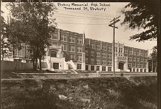
Roxbury Memorial High School is a defunct four-year public high school serving students in ninth through twelfth grades. Originally founded as Roxbury High School, the school was situated at 26 Townsend Street, in the Roxbury neighborhood of Boston, Massachusetts, United States from 1926 until its closure in 1960.
Paul Parks was an American civil engineer. Parks became the first African American Secretary of Education for Massachusetts, and was appointed by Governor Michael Dukakis to serve from 1975 until 1979. Mayor Raymond Flynn appointed Parks to the Boston School Committee, where he was also the first African American.

William J. Devine Memorial Golf Course, colloquially referred to as and contained within Franklin Park, is a municipal golf course in the Jamaica Plain neighborhood of Boston, Massachusetts, bordered by the neighborhoods of Dorchester and Roxbury. Established on October 26, 1896, it is the second oldest public golf course in the United States. The course is named after William J. Devine, former Commissioner of Boston's Parks and Recreation Department.

Darryl K. Williams of Roxbury, Boston, Massachusetts and Milton, Massachusetts was an advocate for social justice, compassion and forgiveness as well as a local advocate for accessibility for persons with disabilities. As a 15 year old African-American living in Roxbury, Boston, Massachusetts, Williams became the victim of a school shooting on September 28, 1979, in Charlestown, Boston, Massachusetts while playing at a high school football game. Williams survived the shooting but was paralyzed from the neck down for the rest of his life. Protests, rallies and school walkouts ensued in response, and racial tensions in the city of Boston escalated in the aftermath.

Henry A. Scagnoli (1922–2015) was an American government official who served as deputy mayor and fire commissioner during the administration of Boston Mayor John F. Collins.


