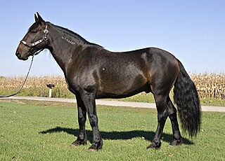
The mustang is a free-roaming horse of the Western United States, descended from horses brought to the Americas by the Spanish. Mustangs are often referred to as wild horses, but because they are descended from once-domesticated animals, they are actually feral horses. The original mustangs were Colonial Spanish horses, but many other breeds and types of horses contributed to the modern mustang, now resulting in varying phenotypes. Some free-roaming horses are relatively unchanged from the original Spanish stock, most strongly represented in the most isolated populations.

Malakoff Diggins State Historic Park is a state park unit preserving the largest hydraulic mining site in California, United States. The mine was one of several hydraulic mining sites at the center of the 1882 landmark case Woodruff v. North Bloomfield Mining and Gravel Company. The mine pit and several Gold Rush-era buildings are listed on the National Register of Historic Places as the Malakoff Diggins-North Bloomfield Historic District. The "canyon" is 7,000 feet (2,100 m) long, as much as 3,000 feet (910 m) wide, and nearly 600 feet (180 m) deep in places. Visitors can see huge cliffs carved by mighty streams of water, results of the mining technique of washing away entire mountains of gravel to wash out the gold. The park is a 26-mile (42 km) drive north-east of Nevada City, California, in the Gold Rush country. The 3,143-acre (1,272 ha) park was established in 1965.
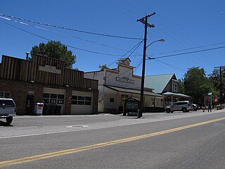
Genoa is an unincorporated town in Douglas County, Nevada, United States. Founded in 1851, it was the first settlement in what became the Nevada Territory. It is situated within Carson River Valley and is approximately 42 miles (68 km) south of Reno. The population was 939 at the 2010 census. It is home to the oldest bar in the state of Nevada which opened in 1853.

Spring Mountain Ranch State Park is a public recreation area located within the Red Rock Canyon National Conservation Area in Nevada's Cottonwood Valley, five miles (8.0 km) northwest of Blue Diamond, Nevada. The state park preserves the historic Sandstone Ranch, which was entered into the National Register of Historic Places as a historic district in 1976.

A brumby is a free-roaming feral horse in Australia. Although found in many areas around the country, the best-known brumbies are found in the Australian Alps region. Today, most of them are found in the Northern Territory, with the second largest population in Queensland. A group of brumbies is known as a "mob" or "band".

A pen is an enclosure for holding livestock. It may also perhaps be used as a term for an enclosure for other animals such as pets that are unwanted inside the house. The term describes types of enclosures that may confine one or many animals. Construction and terminology vary depending on the region of the world, purpose, animal species to be confined, local materials used and tradition. Pen or penning as a verb refers to the act of confining animals in an enclosure.

Tombstone Historic District is a historic district in Tombstone, Arizona that is significant for its association with the struggle between lawlessness and civility in frontier towns of the wild west, and for its history as a boom-and-bust mining center. Located within the historic district is the legendary O.K. Corral associated with the famous Gunfight at the O.K. Corral that actually took place on Fremont Street, near the back entrance to the O.K. Corral, on October 26, 1881. The district was declared a National Historic Landmark in 1961.

The Imnaha Guard Station is a rustic cabin located in the Rogue River-Siskiyou National Forest in western Oregon, United States. It was originally built to house fire crews assigned to patrol the surrounding National Forest. In the 1990s, the United States Forest Service began renting the Imnaha Guard Station to recreational visitors. The Imnaha Guard Station is listed on the National Register of Historic Places.
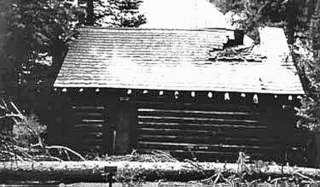
The Death Canyon Barn is a combination barn and ranger patrol cabin in Grand Teton National Park. The barn was built in Death Canyon on the Death Canyon Trail at its junction with the Alaska Basin Trail by the Civilian Conservation Corps in 1935 in the National Park Service rustic style. Located with a clear view of Prospector Mountain, it shares a common style and purpose with the Cascade Canyon Barn to the north in the park, with minor differences attributable to available materials and the preferences of the work crews building the barns.
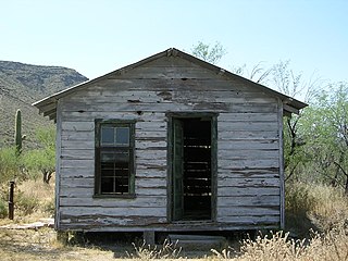
The Bates Well Ranch, also known as the Bates Well, Growler Well, Gray Ranch and El Veit, was one of the fifteen ranches and line camps in the Gray family cattle business in the Sonoran Desert country north of the US-Mexico border in Pima County, Arizona. Operating for nearly 60 years, the ranch is now part of Organ Pipe Cactus National Monument.

Birch Coulee Battlefield in Renville County, Minnesota, United States, was the site of the Battle of Birch Coulee, the costliest military engagement for U.S. forces during the Dakota War of 1862. It is now a historic site with self-guided trails and markers interpreting the battle from both sides. Birch Coulee was nominated to the National Register of Historic Places for having state-level significance in military history, and was listed in 1973.
The Pryor Mountains Wild Horse Range is a refuge for a historically significant herd of free-roaming mustangs, the Pryor Mountain mustang, feral horses colloquially called "wild horses", located in the Pryor Mountains of Montana and Wyoming in the United States. The range has an area of 39,650 acres (160.5 km2) and was established in 1968 along the Montana–Wyoming border as the first protected refuge dedicated exclusively for mustangs. It was the second feral horse refuge in the United States. About a quarter of the refuge lies within the Bighorn Canyon National Recreation Area. A group of federal agencies, led by the Bureau of Land Management, administers the range.

Pinery Station, or The Pinery, was built as a relay station on the Butterfield Overland Mail stagecoach route, located at the crest of Guadalupe Pass in what is now Guadalupe Mountains National Park in the U.S. state of Texas. The station, now in ruins, was built in 1858 and was abandoned the next year. It is located close by U.S. Routes 62/160 and is accessible for tourists.

Canelo Ranger Station, also known as Canelo Work Station, is a historic ranger station in the Coronado National Forest, within Santa Cruz County of southern Arizona. It is located in the ghost town of Canelo, within a small valley between the Canelo Hills on the west and the northern Huachuca Mountains on the east.

The Cathedral Valley Corral was constructed around 1900 by local cattlemen in the northern portion of what is now Capitol Reef National Park in Utah. It is one of the oldest examples of ranching use in the park. It coincided with a change in the use of the land, where cattle were grazed on the open range and collected into corrals for branding, vaccination and other procedures. The extensive use of open-range grazing practices led to the de-vegetation of portions of the area. The corral was used by the Jeffery and Morrel families. The corral site uses sandstone cliffs as part of the enclosure, with a wood fence closing off an alcove in a cliff. The pen is subdivided into a larger and smaller enclosure, with a cattle chute off the small pen.

The Churchill County Courthouse, at 10 Williams St. in Fallon, Nevada, was erected in 1903. It was designed by Reno, Nevada, architect Ben Leon in Classical Revival style, including a monumental portico with two pairs of columns having Ionic capitals. It served as the county courthouse until 1973 and then was used for offices.
The Natural Corrals is an Area of Critical Environmental Concern and an archeological site in Sweetwater County, Wyoming. The Natural Corrals Archeological Site has Smithsonian trinomial designation of 48SW336.
The Darlington Agency was an Indian agency on the Cheyenne and Arapaho Indian Reservation prior to statehood in present-day Canadian County, Oklahoma. The agency was established in 1870. The agency established at Fort Supply the previous year was moved to a more accessible location for the tribes. Brinton Darlington, a Quaker for whom the agency was named, was the first United States Indian agent at the agency, a position he held until his death in 1872.
The La Puente Historic District, near Los Ojos, New Mexico, was listed on the National Register of Historic Places in 1985.

