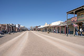
Tombstone is a city in Cochise County, Arizona, United States, founded in 1879 by prospector Ed Schieffelin in what was then Pima County, Arizona Territory. It became one of the last boomtowns in the American frontier. The town grew significantly into the mid-1880s as the local mines produced $40 to $85 million in silver bullion, the largest productive silver district in Arizona. Its population grew from 100 to around 14,000 in less than seven years. It is best known as the site of the Gunfight at the O.K. Corral and presently draws most of its revenue from tourism.

Tonopah is an unincorporated town in and the county seat of Nye County, Nevada, United States. Nicknamed the Queen of the Silver Camps for its mining-rich history, it is now primarily a tourism-based resort city, notable for attractions like the Mizpah Hotel and the Clown Motel.

Virginia City is a census-designated place (CDP) that is the county seat of Storey County, Nevada, and the largest community in the county. The city is a part of the Reno–Sparks Metropolitan Statistical Area.

Pioche is an unincorporated town in Lincoln County, Nevada, United States, approximately 180 miles (290 km) northeast of Las Vegas. U.S. Route 93 is the main route to Pioche and bypasses the town center just to the east, with Nevada State Route 321 and Nevada State Route 322 providing direct access. Its elevation is 6,060 feet (1,850 m) above sea level. Pioche is the county seat of Lincoln County. Pioche is named after François Louis Alfred Pioche, a San Francisco financier and land speculator originally from France. The town's population was 1,002 at the 2010 census.

Austin is an unincorporated small town in, and former county seat of, Lander County, Nevada, United States. In 2020, the census-designated place of Austin had a population of 167. It is located on the western slopes of the Toiyabe Range at an elevation of 6,575 feet (2,004 m). U.S. Route 50 passes through the town.

South Pass City is an unincorporated community in Fremont County, Wyoming, United States. It is located 2 miles (3 km) south of the intersection of highways 28 and 131. A former station on the Oregon Trail, it became a ghost town after later gold mines were closed. The entire community is listed on the National Register of Historic Places. The closest town is Atlantic City.

Aurora is a ghost town in Mineral County in the west central part of the US state of Nevada, approximately 22 mi (35 km) southwest of the town of Hawthorne, three miles from the California border.

Silver City is a Census Designated Place and small residential community in Lyon County, Nevada, USA, near the Lyon/Carson border. The population as of the 2020 census was 155.

Silver Peak is an unincorporated community and census-designated place (CDP) in Esmeralda County, Nevada, United States. It lies along State Route 265, 20 miles (32 km) south of U.S. Route 6 and 30 miles (48 km) west of Goldfield, the county seat of Esmeralda County. It has a post office, with the ZIP code of 89047. The population of Silver Peak was 142 as of 2019.

Ione, Nevada, is a ghost town in Nye County, Nevada, located approximately 23 miles (37 km) east of Gabbs, Nevada.

Mogollon, also called the Mogollon Historic District, is a former mining town located in the Mogollon Mountains in Catron County, New Mexico, United States. Located east of Glenwood and Alma, it was founded in the 1880s at the bottom of Silver Creek Canyon to support the gold and silver mines in the surrounding mountains. The "Little Fannie" mine became the most important employer for the town. During the 1890s, Mogollon had a transient population of between 3,000 and 6,000 miners. Because of its isolation, it had a reputation as one of the wildest mining towns in the West. Today Mogollon is listed as Fannie Hill Mill and Company Town Historic District on the National Register of Historic Places.
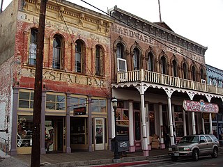
Virginia City Historic District is a National Historic Landmark District encompassing the former mining villages of Virginia City and Gold Hill, both in Storey County, as well as Dayton and Silver City, both to the south in adjacent Lyon County, Nevada, United States. Declared a National Historic Landmark in 1961, the district is one of only six in the state of Nevada.
French Corral is an unincorporated community approximately five miles west of California State Highway 49 in Nevada County, California, United States.

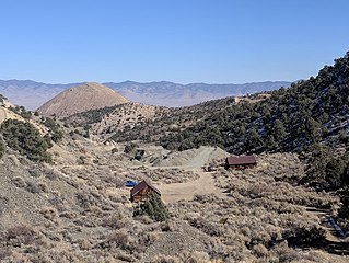
The Berlin Historic District encompasses the ghost town of Berlin in Nye County, Nevada. The town was established in 1897 as part of the Union Mining District after the opening of the Berlin Mine the previous year. The name is a transfer from Berlin, in Germany, the native land of a share of the local prospectors. The town never prospered to the same extent as other boom towns like Tonopah and Goldfield, and declined following the Panic of 1907. The town was largely abandoned by 1911. The site was acquired by the state of Nevada as part of Berlin–Ichthyosaur State Park in 1970.

Eureka Historic District is a historic district in Eureka, Nevada, United States, that is listed on the National Register of Historic Places.

Treasure Hill is an east-jutting spur of the White Pine Range of White Pine County in the east central region of the U.S. state of Nevada. It lies to the east of Mount Hamilton and to the northwest of Mokomoke Hill. It is noted for a silver mining boom in the late 1860s: between 1867 and 1880, the total production from area mines was valued at $20 million. The rush drew thousands to new towns such as Hamilton, situated at the northern base of the hill, and Treasure City, located near its peak, 2.5 miles (4.0 km) from Hamilton.

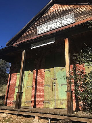
The Stone Jail Building and Row House are two adjacent stone buildings located on Water Street in Tonopah, Nevada. The jail was built in 1903 and the adjacent row house in 1908. Both building were at one time used as a brothel. The buildings were added to the National Register of Historic Places in 1982.
Pine Grove is a ghost town in Lyon County, Nevada, United States.


