
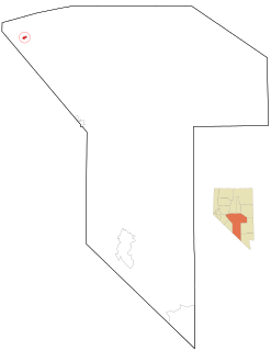
Battle Mountain is an unincorporated town in and the county seat of Lander County, Nevada, United States. The population was 3,635 at the 2010 census. Its primary economic base is gold mining and to a lesser extent, legalized gambling.
Gabbs is an unincorporated town in Nye County, Nevada, United States. The population was 269 at the 2010 census and it is the northernmost community of Greater Las Vegas.

The Gold Country is a historic region in the northern portion of the U.S. state of California, that is primarily on the western slope of the Sierra Nevada. It is famed for the mineral deposits and gold mines that attracted waves of immigrants, known as the 49ers, during the 1849 California Gold Rush.

Dog Town is a gold rush era ghost town in Mono County, California. It is located at 38°10′13″N119°11′51″W, on Dog Creek, near the junction of Clearwater and Virginia Creeks, about 6 miles (10 km) south-southeast of Bridgeport, at an elevation of 7057 feet.

Panamint City is a ghost town in the Panamint Range, near Death Valley, in Inyo County, California, US. It is also known by the official Board of Geographic Names as Panamint. Panamint was a boom town founded after silver and copper were found there in 1872. By 1874, the town had a population of about 2,000. Its main street was one mile (1.6 km) long. Panamint had its own newspaper, the Panamint News. Silver was the principal product mined in the area. The town is located about three miles northwest of Sentinel Peak. According to the National Geographic Names Database, NAD27 latitude and longitude for the locale are 36°07′06″N117°05′43″W, and the feature ID number is 1661185. The elevation of this location is identified as being 6,280 feet AMSL. The similar-sounding Panamint Springs, California, is located about 25.8 miles at 306.4 degrees off true north near Panamint Junction.
Round Mountain is an unincorporated town in Nye County, Nevada, United States. The population of Round Mountain as of 2014 is 1,868. The town's ZIP code is 89045.

Tuscarora is an unincorporated community in Elko County, Nevada, United States. The community lies on the east side of the Tuscarora Mountains approximately 40 miles north of Carlin. Tuscarora is part of the Elko Micropolitan Statistical Area. Far from being a ghost town, as several websites proclaim, Tuscarora is home to two schools, a library, a post office and a bar and grill, as well as homes for very much alive residents.
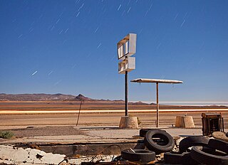
Coaldale is a former mining town and true ghost town in Esmeralda County, Nevada, located at the junction of U.S. Route 6 and U.S. Route 95 about 40 miles (64 km) west of Tonopah.

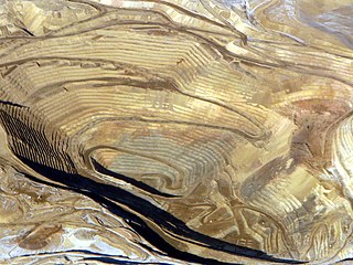
The Getchell Mine is an underground gold mine in the Potosi Mining District of Humboldt County, Nevada, on the east flank of the Osgood Mountains, 35 miles northeast of Winnemucca. Prospectors Edward Knight and Emmet Chase discovered gold in 1933 and located the first claims in 1934. With the financial backing of Noble Getchell and George Wingfield, the Getchell Mine, Inc. was organized in 1936 and the mine was brought into production in 1938.

French Corral is an unincorporated community approximately five miles west of California State Highway 49 in Nevada County, California.
Marietta, Nevada, was a town in Mineral County, Nevada. It is now a ghost town.
Gaston is the site of a former mining community in Nevada County, California. Gaston lies at an elevation of 5062 feet on the Gaston Ridge. The Gaston Ridge historically, was often referred to as God's Country, because of its wild and somewhat inaccessible beauty. Gaston is located 3.25 miles (5.2 km) south of Graniteville and about 4 miles northeast of the town of Washington. It is near the intersection of what are now Gaston and Hoosier Roads, in the Tahoe National Forest.

El Dorado Canyon is a canyon in southern Clark County, Nevada famed for its rich silver and gold mines. The canyon was named in 1857 by steamboat entrepreneur Captain George Alonzo Johnson when gold and silver was discovered here. It drains into the Colorado River at the former site of Nelson's Landing.
St. Peter's Dome is a granite-topped peak on Pikes Peak massif in the Pike National Forest. The peak, at 9,528 feet (2,904 m) in elevation, is located in El Paso County, Colorado, above Colorado Springs. It is located about 8 miles (13 km) from Colorado Springs along Old Stage and Gold Camp Roads. Old Stage Road is picked up behind The Broadmoor and Gold Camp Road winds through Cheyenne Canyon.
San Juan or Upper Camp is a ghost town that was a mining camp of the Eldorado Mining District. It was located in the upper reach of El Dorado Canyon, just below the present day location of Nelson in Clark County, Nevada.
Athens is a former mining settlement in Nye County, Nevada. It was established after a boom in 1910, but was deserted that same year. After the Warrior mine was founded, Athens revived and was inhabited until 1939, when the mining operations were ceased.
Juniper Springs is a former mining camp in Nye County, Nevada, that was inhabited in 1910. The mining camp was founded in the summer of 1910 on the location where N. E. Dyer had found ore. The camp was founded close to the competing camp Athens. Juniper Springs was owned by Dyer, who gave away free lots. In Athens, lots were sold for $50 and $75. The Juniper Lodging House and a store, that was owned by Guy Eckley, were the first businesses to open in Juniper Springs. On July 9, 1910, the Athens Mining District, that comprised Juniper Springs and Athens, was organized at a meeting with over fifty attendees. Juniper Springs and Athens merged in 1910 and the newly created mining camp was given the name Athens. Athens was populated until 1939.
Atwood is a former mining settlement located 35 miles (56 km) northeast of Mina in Nye County, Nevada. Founded in 1901, it was the most important mining village in the Fairplay Mining District, that was called "Atwood Mining District" as well. After Atwood was totally deserted in 1908, the settlement revived in 1914. The last resident left the mining settlement in 1959. Currently, only one foundation and fragments of glass remain.
Johnnie is a populated place in Nye County, in the U.S. state of Nevada about 15 miles north of Pahrump.
Quartz Mountain is an abandoned post office, ghost town, and mine, located in Nye County, Nevada, United States. Quartz Mountain was a huge interest to more than 15 mining companies in the period between 1926 and 1930. The mines in the area contained high-grade silver and lead ores.

