
Churchill County is a county in the western U.S. state of Nevada. As of the 2010 census, the population was 24,877. Its county seat is Fallon. Named for Mexican–American War hero brevet Brigadier General Sylvester Churchill, the county was formed in 1861. Churchill County comprises the Fallon, NV Micropolitan Statistical Area. It is in northwestern Nevada. Churchill County is noteworthy in that it owns and operates the local telephone carrier, Churchill County Communications.

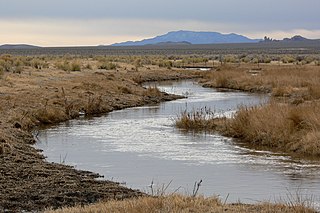
The Humboldt River is an extensive river drainage system located in north-central Nevada. It extends in a general east-to-west direction from its headwaters in the Jarbidge, Independence, and Ruby Mountains in Elko County, to its terminus in the Humboldt Sink, approximately 225 direct miles away in northwest Churchill County. Most estimates put the Humboldt River at 300 miles (480 km) to miles 330 miles (530 km) long however, due to the extensive meandering nature of the river, its length may be more closely estimated at 380 miles (612 km). It is located within the Great Basin Watershed and is the third longest river in the watershed behind the Bear River at 355 miles (570 km) and the Sevier River at 325 miles (523 km). The Humboldt River Basin is the largest sub-basin of the Great Basin encompassing an area of 16,840 square miles (43,615 km2). It is the only major river system wholly contained within the state of Nevada.

The East Walker River is an approximately 90 miles (140 km) long, tributary of the Walker River, in eastern California and western Nevada in the United States. It drains part of the eastern side of the Sierra Nevada in the watershed of Walker Lake in the Great Basin.

The West Walker River is a tributary of the Walker River, approximately 95 miles (153 km) long, in eastern California and western Nevada in the United States. It drains part of the Sierra Nevada range along the California-Nevada border in the watershed of Walker Lake in the Great Basin. The river derives its name from Joseph R. Walker, a mountain man.

The Feather River is the principal tributary of the Sacramento River, in the Sacramento Valley of Northern California. The river's main stem is about 73 miles (117 km) long. Its length to its most distant headwater tributary is just over 210 miles (340 km). The main stem Feather River begins in Lake Oroville, where its four long tributary forks join—the South Fork, Middle Fork, North Fork, and West Branch Feather Rivers. These and other tributaries drain part of the northern Sierra Nevada, and the extreme southern Cascades, as well as a small portion of the Sacramento Valley. The total drainage basin is about 6,200 square miles (16,000 km2), with approximately 3,604 square miles (9,330 km2) above Lake Oroville.

The Reese River is a 181-mile-long (291 km) tributary of the Humboldt River, located in central Nevada in the western United States.
The White River is a small and discontinuous 138-mile-long (222 km) river located in southeastern Nevada notable for several endemic species of fish. The river was named for F. A. White, a 19th-century explorer.
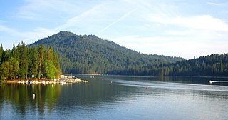
Bass Lake is located in the Sierra National Forest, of Madera County, California, approximately 14 mi (23 km) south of the entrance to Yosemite National Park. The lake is approximately four miles long and one-half mile wide.

Paradise Valley is a census-designated place (CDP) in Humboldt County, Nevada, United States, near the Santa Rosa Ranger District of Humboldt National Forest. It is located at the northern terminus of Nevada State Route 290, about 19 miles (31 km) northeast of U.S. Highway 95 and a total of 40 miles (64 km) north of Winnemucca. The town is located in a broad valley, with the Santa Rosa Range of mountains just to the northwest. At the 2010 census, the population of the CDP was 109.

The Santa Ynez Valley is located in Santa Barbara County, California, between the Santa Ynez Mountains to the south and the San Rafael Mountains to the north. The Santa Ynez River flows through the valley from east to west. The Santa Ynez Valley is separated from the Los Alamos Valley, to the northwest, by the Purisima Hills, and from the Santa Maria Valley by the Solomon Hills. The Santa Rita Hills separate the Santa Ynez Valley from the Santa Rita and Lompoc Valleys to the west.

State Route 228 (SR 228), also known as Jiggs Highway, is a 20.803-mile (33.479 km) state highway in Elko County, Nevada, United States, that connects Jiggs with Nevada State Route 227 in Spring Creek.
Ursine is an unincorporated community and census-designated place in Lincoln County, Nevada, United States. It is located in the foothills of the White Rock Mountains on Eagle Valley about two miles downstream from the Eagle Valley Reservoir and Spring Valley State Park. The population was 91 at the 2010 census.
Carp, Nevada is an extinct town in Lincoln County, Nevada, United States located 35 miles (56 km) south of Caliente. It sits on the Meadow Valley Wash, which empties into Lake Mead.

Desert Hills is an unincorporated community in Maricopa County, Arizona, United States. It is located in the New River census-designated place. Sitting on over 4.31 sq. mi. of the 85086 Zip Code, And the (623) Area Code, forming the southern boundary of Anthem and the western boundary of Cave Creek: about 30 miles (48 km) north of downtown Phoenix. Located east of the I-17, Desert Hills is roughly bounded by 35th Avenue to the west, Desert Hills Drive to the north, 28th Street to the east. The majority of Desert Hills sits north of Carefree Highway, however, a small portion resides south from Central Avenue to the west to 14th Street to the east: and south for one mile to Dove Valley Road. Note a community known as Tramonto, falls within these boundaries but is considered part of Phoenix.
Red Clover Creek is a west-northwestward-flowing stream originating on Horton Ridge east of the Sierra Nevada crest in Plumas County, California, United States. It courses 27 miles (43 km) through Dotta Canyon and Red Clover Valley to its confluence with Last Chance Creek in Genesee Valley, just above its confluence with Indian Creek, which flows into the East Branch North Fork Feather River. The Red Clover Valley sits at an elevation of about 5,400 feet (1,600 m) and is located on the east side of the Sierra Nevada crest, approximately 60 miles (97 km) north of Truckee and 30 miles (48 km) east of Quincy.
Potts is a ghost town and abandoned ranching property in Monitor Valley, Nye County, Nevada, approximately 2 miles east of Nevada State Route 82.
Wolf is a historic agricultural community in the western part of Nevada County. It lies about 12 miles south of Grass Valley at an elevation of 1578 feet. It is centered around the intersection of present day Wolf and Garden Bar roads.

The Rye Patch Reservoir is a reservoir on the Humboldt River in the U.S. State of Nevada. It is located about 22 miles northeast of the town of Lovelock, and is managed by the Pershing County Water Conservation District. The reservoir stores water for the agricultural area surrounding Lovelock, which is at the far downstream reach of the Humboldt, near the Humboldt Sink. Since the Lovelock area receives a mere 5.76 inches of rain annually, agriculture requires irrigation, but the high variability of the Humboldt means that water storage is necessary for irrigation to be feasible.
Excelsior is a ghost town in Elko County, in the U.S. state of Nevada.
Bryman, is a populated place in the central Mojave Desert, within San Bernardino County, California. It lies along the Mojave River in the northern Victor Valley, at an elevation of 2,526 feet . It is on the historic U.S. Route 66, 5 miles north of Oro Grande, and south of Helendale.


