
Blue Diamond is a census-designated place (CDP) in Clark County, Nevada, United States. The population was 290 at the 2010 census.

Paradise is an unincorporated town and census-designated place (CDP) in Clark County, Nevada, United States, adjacent to the city of Las Vegas. The population was 223,167 at the 2010 census, making it the most populous unincorporated community in Nevada. As an unincorporated town, it is governed by the Clark County Commission with input from the Paradise Town Advisory Board. Paradise was formed on December 8, 1950.

Gerlach, Nevada is a census-designated place (CDP) in Washoe County, Nevada, United States. The population was 206 at the 2010 census. It is part of the Reno–Sparks Metropolitan Statistical Area. Prior to 2010, Gerlach was part of the Gerlach–Empire census-designated place. The town of Empire is now a separate CDP. The next nearest town, Nixon, is 60 miles (100 km) to the south on a reservation owned by the Pyramid Lake Paiute Tribe. The Fly Geyser is located near Gerlach.

Eldorado Resort Casino is a hotel and casino located in Downtown Reno, Nevada. It anchors a network of connected hotel-casinos in the downtown Reno core that included Circus Circus Reno and Silver Legacy Reno and are owned and operated by Eldorado Resorts.
Coaldale is a former mining town and true ghost town in Esmeralda County, Nevada, located at the junction of U.S. Route 95 and U.S. Route 6 about 40 miles west of Tonopah, Nevada.

Arden, Nevada was an unincorporated community in Clark County, Nevada. The area is now part of the town of Enterprise. Located about 7 miles (11 km) southwest of Las Vegas, the area is experiencing rapid growth in housing development on land formerly owned by the Bureau of Land Management.

The Reno Gazette Journal is the main daily newspaper for Reno, Nevada. It is owned and operated by the Gannett Company. It came into being when the Nevada State Journal and the Reno Evening Gazette were combined on October 7, 1983.
Nevada became the 36th state on October 31, 1864, after telegraphing the Constitution of Nevada to the Congress days before the November 8 presidential election. Statehood was rushed to help ensure three electoral votes for Abraham Lincoln's reelection and add to the Republican congressional majorities.

Ruby Hill is a ghost town in Eureka County, in the central part of the U.S. state of Nevada, approximately 2.6 mi (4.2 km) west of the town of Eureka, Nevada. In 1910, the town was destroyed by a powerful storm that washed away the railroad and buildings and rendered the town uninhabitable.
Fitzgeralds Gaming was a gaming and hotel company based in Reno, Nevada, that operated four casinos under the Fitzgeralds brand. It filed for Chapter 11 bankruptcy in December 2000, and subsequently sold all its properties.
El Dorado Canyon is a canyon in southern Clark County, Nevada famed for its rich silver and gold mines. The canyon was named in 1857 by steamboat entrepreneur Captain George Alonzo Johnson when gold and silver was discovered here. It drains into the Colorado River at the former site of Nelson's Landing.

Fairview is a ghost town in Churchill County, Nevada, in the United States of America.
St. Peter's Dome is a granite-topped peak on Pikes Peak massif in the Pike National Forest. The peak, at 9,528 feet (2,904 m) in elevation, is located in El Paso County, Colorado, above Colorado Springs. It is located about 8 miles (13 km) from Colorado Springs along Old Stage and Gold Camp Roads. Old Stage Road is picked up behind The Broadmoor and Gold Camp Road winds through Cheyenne Canyon.
San Juan or Upper Camp is a ghost town that was a mining camp of the Eldorado Mining District. It was located in the upper reach of El Dorado Canyon, just below the present day location of Nelson in Clark County, Nevada.
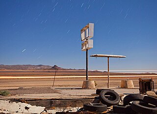
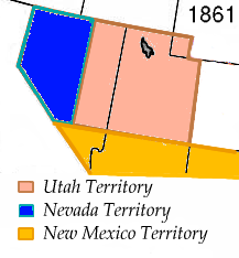
Lucky Jim Camp sometimes called Lucky Camp is a ghost town site in Clark County, Nevada. It was within New Mexico Territory when founded in 1862.
Buster Falls, now a ghost town, was a mining camp in El Dorado Canyon above Huse Spring and the Techatticup Mine in the Colorado Mining District during the time of the American Civil War. The source of the name of the camp is unknown. Its site lay along the canyon a mile above the site of Lucky Jim Camp. The site would be just above the El Dorado Canyon's confluence with Copper Canyon.
Quartette or Quartette Mill or Quartette Landing, was a mining settlement, location of the stamp mill of the Quartette Mining Company, owner of the largest mine in the Searchlight Mining District and a steamboat landing on the Colorado River, in what is now Clark County, Nevada. It lay at an elevation of 646 feet.

Archer is a former mining camp in Nye County, Nevada, that was inhabited in 1904. It was situated 2 miles southeast of Tonopah. The mining camp, that only contained tents and no permanent structures or frame buildings, was founded in the summer of 1904, because gold was found over there. Archer was gone by the fall, since no additional ledges with gold were found. There are no remains of the mining camp.
Atwood is a former mining settlement located 35 miles (56 km) northeast of Mina in Nye County, Nevada. Founded in 1901, it was the most important mining village in the Fairplay Mining District, that was called "Atwood Mining District" as well. After Atwood was totally deserted in 1908, the settlement revived in 1914. The last resident left the mining settlement in 1959. Currently, only one foundation and fragments of glass remain.


