
Nye County is a county in the U.S. state of Nevada. As of the 2020 census, the population was 51,591. Its county seat is Tonopah. At 18,159 square miles (47,030 km2), Nye is Nevada's largest county by area and the third-largest county in the contiguous United States, behind Coconino County of Arizona and San Bernardino County of California.

Esmeralda County is a county in the southwestern portion of the U.S. state of Nevada. As of the 2020 census, the population was 729, making it the least populous county in Nevada. Esmeralda County does not have any incorporated communities. Its county seat is the town of Goldfield.
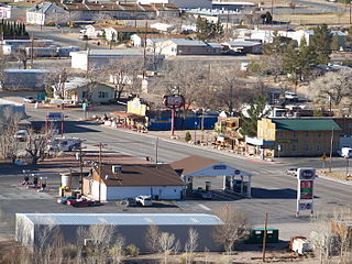
Beatty is an unincorporated town along the Amargosa River in Nye County, Nevada, United States. U.S. Route 95 runs through the town, which lies between Tonopah, about 90 miles (140 km) to the north and Las Vegas, about 120 miles (190 km) to the southeast. State Route 374 connects Beatty to Death Valley National Park, about 8 miles (13 km) to the west.

Tonopah is an unincorporated town in, and the county seat of, Nye County, Nevada, United States. Nicknamed the Queen of the Silver Camps for its mining-rich history, it is now primarily a tourism-based resort city, notable for attractions like the Mizpah Hotel and the Clown Motel.
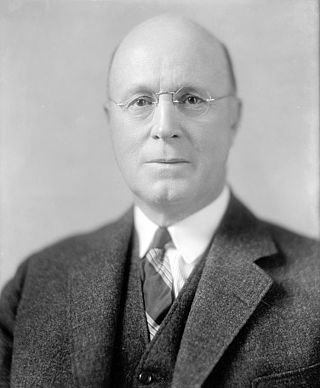
Tasker Lowndes Oddie was an American attorney and politician who served as the 12th Governor of Nevada and a United States Senator. He was a member of the Republican Party.

The Toiyabe Range is a mountain range in Lander and Nye counties, Nevada, United States. Most of the range is included within the Humboldt-Toiyabe National Forest. The highest point in the range, near its southern end, is Arc Dome, an area protected as the Arc Dome Wilderness. The highest point in Lander County, Bunker Hill, is also located within the Toiyabe Range. The range starts in northwestern Nye County north of Tonopah, Nevada and runs approximately 120 miles (190 km) north-northeast into southern Lander County, making it the second longest range in the state.

Rhyolite is a ghost town in Nye County, in the U.S. state of Nevada. It is in the Bullfrog Hills, about 120 miles (190 km) northwest of Las Vegas, near the eastern boundary of Death Valley National Park.

The Big Smoky Valley is a landform of the Tonopah Basin between the Toiyabe and Toquima mountain ranges. It is about 100 miles (160 km) in length.

Railroad Valley is one of the Central Nevada Desert Basins in the Tonopah Basin and is about 80 miles (130 km) long north–south and up to 20 miles (32 km) wide, with some southern areas running southwest to northeast.

The Amargosa Desert is located in Nye County in western Nevada, United States, along the California–Nevada border, comprising the northeastern portion of the geographic Amargosa Valley, north of the Ash Meadows National Wildlife Refuge.
Round Mountain is an unincorporated town in Nye County, Nevada, United States. The population of Round Mountain as of 2014 is 1,868. The town's ZIP code is 89045.

Silver Peak is an unincorporated community and census-designated place (CDP) in Esmeralda County, Nevada, United States. It lies along State Route 265, 20 miles (32 km) south of U.S. Route 6 and 30 miles (48 km) west of Goldfield, the county seat of Esmeralda County. It has a post office, with the ZIP code of 89047. The population of Silver Peak was 142 as of 2019.
Cactus Springs is a ghost town in Nye County, Nevada. It is currently within the boundaries of the Nellis Air Force Range.

State Route 376 is a 100-mile (160 km) state highway in Nye and Lander counties in central Nevada, United States. It connects U.S. Route 6 near Tonopah north to U.S. Route 50 near Austin. The Tonopah–Austin Road existed as early as 1919, and was designated the southernmost segment of State Route 8A before being renumbered to SR 376 in 1976.

Manhattan is an unincorporated town in Nye County, Nevada, located at the end of Nevada State Route 377, about 50 miles (80 km) north of Tonopah, the county seat.

Gold Center was a mining town in Nye County, Nevada. Located in the Bullfrog Mining District south of Tonopah, Gold Center was established in December 1904 with a United States Post Office being authorized on January 21, 1905. The town began publishing its own newspaper in 1907. The location of the town was ideal as it was on the stagecoach route to Rhyolite and Beatty. It was also near the Amargosa River, allowing sufficient water for drinking and for two mills and an ice house. Gold Center also sold water to Rhyolite and Carrara. The Tonopah and Tidewater Railroad, the Las Vegas & Tonopah Railroad and the Bullfrog Goldfield Railroad all ran through Gold Center. Gold Center also had the first brewery in the area which was built underground to maintain a cool temperature.
The Las Vegas–Henderson combined statistical area, known prior to 2013 as the Las Vegas–Paradise–Pahrump combined statistical area, is made up of two counties in southern Nevada and one in northwestern Arizona. The statistical area consists of the Las Vegas–Paradise, NV MSA, the Lake Havasu City–Kingman, AZ MSA and the Pahrump micropolitan statistical area. At the 2010 census, the CSA had a population of 2,195,401.

Bullfrog is a ghost town in Nye County, in the U.S. state of Nevada. It is located at the north end of the Amargosa Desert about 4 miles (6.4 km) west of Beatty. Less than 1 mile (1.6 km) north of Bullfrog are the Bullfrog Hills and the ghost town of Rhyolite. The two ghost towns are about 120 miles (190 km) northwest of Las Vegas, 60 miles (97 km) south of Goldfield, and 90 miles (140 km) south of Tonopah.
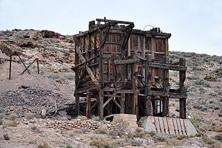
Pioneer is a ghost town in Nye County, in the U.S. state of Nevada. Beginning as a mining camp near the Mayflower and other gold mines in northern Bullfrog Hills, it became a formal town in 1908 and flourished briefly until fire destroyed much of its business district in 1909 and litigation delayed mining. Population peaked at an estimated 2,500 in 1908, and the community survived at least through the closing of the Pioneer post office in 1931. Mining continued near the town site through 1941. Few remnants of Pioneer structures survived through the end of the 20th century.
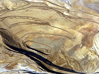
The Round Mountain Gold Mine is an open pit gold mine in Round Mountain, Nevada. The mine is operated and owned by Kinross Gold.


