Java, Virginia

Last updated

Java is an unincorporated community in Pittsylvania County, in the U.S. state of Virginia. Like many such communities, Java has no focal point beyond a US Post Office alongside the local volunteer fire department building. The community extends east a mile or so into Halifax County. Java contains no manufacturing operations beyond one commercial saw mill which—like local tobacco farms—is a significant employer in the area. That mill and others have increasingly been supplied by logging operations that have, potentially, been creating more farmable land through their clear-cutting practices. A downside to this clearcutting has been a loss of natural habitat for the native wildlife, including deer and bear.

Unincorporated area Region of land not governed by own local government

In law, an unincorporated area is a region of land that is not governed by a local municipal corporation; similarly an unincorporated community is a settlement that is not governed by its own local municipal corporation, but rather is administered as part of larger administrative divisions, such as a township, parish, borough, county, city, canton, state, province or country. Occasionally, municipalities dissolve or disincorporate, which may happen if they become fiscally insolvent, and services become the responsibility of a higher administration. Widespread unincorporated communities and areas are a distinguishing feature of the United States and Canada. In most other countries of the world, there are either no unincorporated areas at all, or these are very rare; typically remote, outlying, sparsely populated or uninhabited areas.

Pittsylvania County, Virginia U.S. county in Virginia

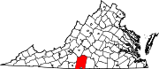
Pittsylvania County is a county located in the Commonwealth of Virginia. As of the 2010 census, the population was 63,506. Its county seat is Chatham.

U.S. state constituent political entity of the United States

In the United States, a state is a constituent political entity, of which there are currently 50. Bound together in a political union, each state holds governmental jurisdiction over a separate and defined geographic territory and shares its sovereignty with the federal government. Due to this shared sovereignty, Americans are citizens both of the federal republic and of the state in which they reside. State citizenship and residency are flexible, and no government approval is required to move between states, except for persons restricted by certain types of court orders.

Notable people include international speaker and traveler Alex “Shelly” Lisk and Minnesota Public Radio host Angela Davis. [1]

Minnesota Public Radio (MPR), is a public radio network for the state of Minnesota. With its three services, News & Information, Classical Music and The Current, MPR operates a 46-station regional radio network in the upper Midwest.

Related Research Articles

Pendleton County, West Virginia U.S. county in West Virginia

Pendleton County is a county located in the U.S. state of West Virginia. As of the 2010 census, the population was 7,695, making it the fifth-least populous county in West Virginia. Its county seat is Franklin. The county was created by the Virginia General Assembly in 1788 from parts of Augusta, Hardy, and Rockingham Counties and was named for Edmund Pendleton (1721–1803), a distinguished Virginia statesman and jurist. Pendleton County was strongly pro-Confederate during the American Civil War; however, there were pockets of Unionists who supported the state government in Wheeling.

Mebane, North Carolina City in North Carolina, United States

Mebane is a city located mostly in Alamance County, North Carolina, United States, and partly in Orange County, North Carolina. The town was named for Alexander Mebane, an American Revolutionary War general and member of the U.S. Congress. It was incorporated as "Mebanesville" in 1881, and in 1883 the name was changed to "Mebane". It was incorporated as a city in 1987. The population as of the 2010 census was 11,393. Mebane is one of the fastest growing municipalities in North Carolina. Mebane straddles the Research Triangle and Piedmont Triad Regions of North Carolina. The Alamance County portion is part of the Burlington Metropolitan Statistical Area, which is a component of the Greensboro-Winston-Salem-High Point Combined Statistical Area. The Orange County portion is part of the Durham-Chapel Hill Metropolitan Statistical Area, which is a component of the Raleigh-Durham-Chapel Hill Combined Statistical Area.

Camp Peary American military base

Camp Peary is an approximately 9,000 acre U.S. military reservation in York County near Williamsburg, Virginia. Officially referred to as an Armed Forces Experimental Training Activity (AFETA) under the authority of the Department of Defense, Camp Peary hosts a covert CIA training facility known as "The Farm", which is used to train officers of the CIA's Directorate of Operations, as well as those of the DIA's Defense Clandestine Service, among other intelligence entities. Camp Peary has a sister facility, "The Point", located in Hertford, North Carolina.

Tri-Cities, Virginia

The Tri-Cities of Virginia is an area in the Greater Richmond Region which includes the three independent cities of Petersburg, Colonial Heights, and Hopewell and portions of the adjoining counties of Chesterfield, Dinwiddie, and Prince George in south-central Virginia. Other unincorporated communities located in the Tri-Cities area include Ettrick, Fort Lee, and City Point, the latter formerly a historic incorporated town which was annexed to become part of the City of Hopewell.

Andersons Mill is an unincorporated community in Pittsylvania County, in the U.S. state of Virginia.

Callands, Virginia Unincorporated Community

Callands is an unincorporated community in Pittsylvania County, in the U.S. state of Virginia. It was named after Samuel Calland, a native of Scotland that immigrated during the 18th century, whose general store became a popular fixture of the community. The area around the store served as the county seat of Pittsylvania County until the end of 1776.

Henrys Mill is an unincorporated community in Pittsylvania County, in the U.S. state of Virginia.

Hollys Mill is an unincorporated community in Pittsylvania County, in the U.S. state of Virginia.

Jones Mill is an unincorporated community in Pittsylvania County, in the U.S. state of Virginia.

Laniers Mill is an unincorporated community in Pittsylvania County, in the U.S. state of Virginia.

Motleys Mill is an unincorporated community in Pittsylvania County, in the U.S. state of Virginia.

Pleasant Grove is an unincorporated community in Henry County, Virginia, in the U.S. state of Virginia. Located at the crossroads of Stones Dairy, Hodges Farm, Preston, and Wingfield Orchard Roads. It is about 7 miles west of Martinsville, between Horse Pasture and Bassett, Virginia.

Stony Mill is an unincorporated community in Pittsylvania County, in the U.S. state of Virginia.

Swansons Mill is an unincorporated community in Pittsylvania County, in the U.S. state of Virginia.

Vadens Mill is an unincorporated community in Pittsylvania County, in the U.S. state of Virginia.

Whitmell, Virginia human settlement in Virginia, United States of America

Whitmell is an unincorporated community in Pittsylvania County, in the U.S. state of Virginia. It is the location of the now-closed historic Whitmell Farm-Life School named for Whitmell P. Tunstall, a lawyer and state legislator.

Kennerdell, Pennsylvania CDP in Pennsylvania, United States

Kennerdell is a census-designated place located in Rockland Township, Venango County in the state of Pennsylvania. The community is located in southern Venango County along the Allegheny River. As of the 2010 census the population was 247 residents.

Pioneer is an unincorporated community in Barry County, Missouri, United States.

New Albany is an unincorporated community in Mahoning County, in the U.S. state of Ohio.

Winkler is an unincorporated community in southeast Phelps County, in the U.S. state of Missouri. The community is located on Missouri Route 68, thirteen miles north of Salem and eleven miles south of St. James.

References

  1. "Why Emmy-winning TV anchor Angela Davis made the leap to public radio." startribune.com

Coordinates: 36°50′09″N79°13′40″W / 36.83583°N 79.22778°W / 36.83583; -79.22778

Geographic coordinate system Coordinate system

A geographic coordinate system is a coordinate system that enables every location on Earth to be specified by a set of numbers, letters or symbols. The coordinates are often chosen such that one of the numbers represents a vertical position and two or three of the numbers represent a horizontal position; alternatively, a geographic position may be expressed in a combined three-dimensional Cartesian vector. A common choice of coordinates is latitude, longitude and elevation. To specify a location on a plane requires a map projection.