Jefferson, Colorado

Last updated

Jefferson, Colorado
DSCN3710 jeffersoncolorado e 600.jpg
The community of Jefferson, showing one-room school house, seen looking eastward from U.S. Route 285, May 2005
USA Colorado location map.svg
Red pog.svg
Jefferson, Colorado
Location within the state of Colorado
Coordinates: 39°22′38″N105°48′02″W / 39.37722°N 105.80056°W / 39.37722; -105.80056
Country Flag of the United States (23px).png  United States
State Flag of Colorado.svg  Colorado
County Park [1]
Elevation
[2]
9,502 ft (2,896 m)
Time zone UTC-7 (MST)
  Summer (DST) UTC-6 (MDT)
ZIP code [3]
80456
GNIS feature ID204725 [2]

Jefferson is an unincorporated community in Park County, Colorado, United States.

Contents

Description

Jefferson in early 1900s Railroad Depot - Jefferson, Colorado, early 1900s.jpg
Jefferson in early 1900s

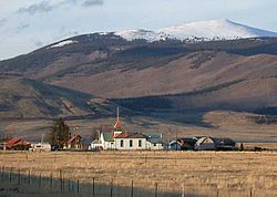
The community is located in the northern end of South Park, along U.S. Route 285 (US 285), approximately 15 miles (24 km) northeast of Fairplay, at the western foot of Kenosha Pass. t lies 6 miles (9.7 km) from Como, 23 miles (37 km) from Bailey, and 37 miles (60 km) from Breckenridge. The community consists largely of a strip of retail businesses along US 285, as well as a small unpaved grid of houses and trailers on the south side of the highway. The most notable landmarks in the community are a historic one-room schoolhouse and the Historic Jefferson Denver, South Park and Pacific Railroad (DSP&P RR)Depot (c. 1880), highly visible in the surrounding grasslands of South Park. The Jefferson Post Office has the ZIP Code 80456. However, the post office closed in 2022. [3]

Climate

Climate data for Jefferson (CoAgMet), Colorado, 2012–2022 normals: 9460ft (2883m)
MonthJanFebMarAprMayJunJulAugSepOctNovDecYear
Mean daily maximum °F (°C)32.2
(0.1)
33.8
(1.0)
42.4
(5.8)
48.2
(9.0)
58.4
(14.7)
71.0
(21.7)
73.2
(22.9)
71.4
(21.9)
67.8
(19.9)
54.4
(12.4)
43.3
(6.3)
32.5
(0.3)
52.4
(11.3)
Daily mean °F (°C)18.0
(−7.8)
19.1
(−7.2)
26.6
(−3.0)
32.7
(0.4)
41.1
(5.1)
51.0
(10.6)
54.8
(12.7)
52.8
(11.6)
48.2
(9.0)
36.3
(2.4)
26.4
(−3.1)
17.6
(−8.0)
35.4
(1.9)
Mean daily minimum °F (°C)3.6
(−15.8)
4.3
(−15.4)
10.6
(−11.9)
17.0
(−8.3)
23.6
(−4.7)
30.8
(−0.7)
36.2
(2.3)
34.0
(1.1)
28.4
(−2.0)
18.2
(−7.7)
9.5
(−12.5)
2.6
(−16.3)
18.2
(−7.7)
Source 1: XMACIS2 [4]
Source 2: CoAgMet [5]

See also

Flag of Colorado.svg  Coloradoportal

Related Research Articles

<span class="mw-page-title-main">Romeo, Colorado</span> Town in Colorado, United States

Romeo is a Statutory Town in Conejos County, Colorado, United States. The population was 302 at the 2020 census. A post office called Romeo was established in 1901. The community derives its name from the surname Romero.

<span class="mw-page-title-main">Ponderosa Park, Colorado</span> Census Designated Place in Colorado, United States

Ponderosa Park is an unincorporated community and a census-designated place (CDP) located in and governed by Elbert County, Colorado, United States. The CDP is a part of the Denver–Aurora–Lakewood, CO Metropolitan Statistical Area. The population of the Ponderosa Park CDP was 3,334 at the United States Census 2020. Elbert County governs the unincorporated community. The Elizabeth post office serves the area.

<span class="mw-page-title-main">Applewood, Colorado</span> Census Designated Place in Colorado, United States

Applewood is an unincorporated community and a census-designated place (CDP) located in and governed by Jefferson County, Colorado, United States. The CDP is a part of the Denver–Aurora–Lakewood, CO Metropolitan Statistical Area. The population of the Applewood CDP was 7,833 at the 2020 United States Census. The Golden post office serves the area.

<span class="mw-page-title-main">Aspen Park, Colorado</span> Census Designated Place in Colorado, United States

Aspen Park is an unincorporated community and a census-designated place (CDP) located in Jefferson County, Colorado, United States. The CDP is a part of the Denver–Aurora–Lakewood, CO Metropolitan Statistical Area. The population of the Aspen Park CDP was 810 at the United States Census 2020. The Aspen Park Metropolitan District provides services. The Conifer post office serves the area.

<span class="mw-page-title-main">Indian Hills, Colorado</span> Census Designated Place in Colorado, United States

Indian Hills is an unincorporated town, a post office, and a census-designated place (CDP) located in and governed by Jefferson County, Colorado, United States. The CDP is a part of the Denver–Aurora–Lakewood, CO Metropolitan Statistical Area. The Indian Hills post office has the ZIP code 80454. At the United States Census 2020, the population of the Indian Hills CDP was 1,474.

<span class="mw-page-title-main">Kittredge, Colorado</span> Census Designated Place in Colorado, United States

Kittredge is an unincorporated town, a post office, and a census-designated place (CDP) located in and governed by Jefferson County, Colorado, United States. The CDP is a part of the Denver–Aurora–Lakewood, CO Metropolitan Statistical Area. The Kittredge post office has the ZIP code 80457. At the United States Census 2020, the population of the Kittredge CDP was 1,308.

<span class="mw-page-title-main">Clifton, Colorado</span> Census-designated place in Mesa County, Colorado, United States

Clifton is a census-designated place (CDP) and post office in and governed by Mesa County, Colorado, United States. It is part of the Grand Junction, CO Metropolitan Statistical Area. The Clifton post office has the ZIP Code 81520. As of the 2020 census, the population of the Clifton CDP was 20,413.

<span class="mw-page-title-main">Conifer, Colorado</span> Unincorporated community in Colorado, United States

Conifer is an unincorporated community in Jefferson County, Colorado, United States. Conifer is located along U.S. Route 285 in the foothills west of Denver.

<span class="mw-page-title-main">Bailey, Colorado</span> Unincorporated community in Colorado, United States

Bailey is an unincorporated community and U.S. Post Office in northeastern Park County, Colorado, United States. Bailey's Post Office ZIP Code is 80421.

<span class="mw-page-title-main">Shawnee, Colorado</span> Unincorporated community in Park County, Colorado, United States

Shawnee is an unincorporated community and post office in northern Park County, Colorado, United States, that is a historic district listed on the National Register of Historic Places (NRHP).

<span class="mw-page-title-main">Grant, Colorado</span> Unincorporated community in Park County, Colorado, United States

Grant is an unincorporated community and a U.S. Post Office in Park County, Colorado, United States.

<span class="mw-page-title-main">Como, Colorado</span> Unincorporated community in Park County, Colorado, United States

Como is an unincorporated community in Park County in the Rocky Mountains of central Colorado, United States. According to the 2010 census, the population of zip code 80432 is 439, including surrounding subdivisions in a 15 mile radius. Metropolitan Como proper usually has a population of 12 to 15 residents, within the Como plat.

<span class="mw-page-title-main">Conejos, Colorado</span> Census Designated Place in Colorado, United States

Conejos is an unincorporated town, a post office, a census-designated place (CDP), and the county seat of Conejos County, Colorado, United States. The Conejos post office has the ZIP Code 81129. At the United States Census 2020, the population of the Conejos CDP was 46. Conejos is the only unincorporated county seat in the State of Colorado.

<span class="mw-page-title-main">Monarch, Colorado</span> Unincorporated community in Chaffee County, Colorado, United States

Monarch is an unincorporated community and a U.S. Post Office located near Monarch Pass in Chaffee County, Colorado, United States. The Monarch U.S. Post Office has the ZIP Code 81227.

<span class="mw-page-title-main">Homelake, Colorado</span> Unincorporated community in Colorado, United States

Homelake is an unincorporated community located in Rio Grande County, Colorado, United States. The Homelake's ZIP code is 81135. The Homelake post office was discontinued in 1965.

<span class="mw-page-title-main">Lewis, Colorado</span> Census-designated place in Colorado, United States

Lewis is an unincorporated town, a post office, and a census-designated place (CDP) located in and governed by Montezuma County, Colorado, United States. The Lewis post office has the ZIP Code 81327. At the 2020 census, the population of the Lewis CDP was 257, down from 302 in 2010.

<span class="mw-page-title-main">Orchard, Colorado</span> Unincorporated community in Colorado, United States

Orchard is an unincorporated town, a post office, and a census-designated place (CDP) located in and governed by Morgan County, Colorado, United States. The CDP is a part of the Fort Morgan, CO Micropolitan Statistical Area. The Orchard post office has the ZIP Code 80649. As of the 2020 census, the population of the Orchard CDP was 76.

<span class="mw-page-title-main">Weston, Colorado</span> Census Designated Place in Colorado, United States

Weston is an unincorporated town, a post office, and a census-designated place (CDP) located in and governed by Las Animas County, Colorado, United States. The Weston post office has the ZIP Code 81091. At the United States Census 2020, the population of the Weston CDP was 53.

<span class="mw-page-title-main">Altona, Colorado</span> Census Designated Place in Colorado, United States

Altona is an unincorporated community and a census-designated place (CDP) located in and governed by Boulder County, Colorado, United States. The CDP is a part of the Boulder, CO Metropolitan Statistical Area. The population of the Altona CDP was 512 at the United States Census 2020. The Boulder post office serves the area.

Parker Dam is an unincorporated community in San Bernardino County, California, United States. Parker Dam is located along the Colorado River across from Arizona 24 miles (39 km) east-northeast of Vidal. It is named after Parker Dam, which impounds the Colorado River nearby. Parker Dam has a post office with ZIP code 92267. The post office opened in 1935 and closed briefly between 1939 and 1940.

References

  1. "US Board on Geographic Names". United States Geological Survey. October 25, 2007. Retrieved January 31, 2008.
  2. 1 2 U.S. Geological Survey Geographic Names Information System: Jefferson, Colorado
  3. 1 2 "ZIP Code Lookup". United States Postal Service. December 28, 2006. Archived from the original (JavaScript/HTML) on November 22, 2010. Retrieved December 28, 2006.
  4. "xmACIS2". National Oceanic and Atmospheric Administration. Retrieved December 9, 2023.
  5. "Info for Jefferson (JFN01)". Colorado State University. Retrieved December 9, 2023.

Commons-logo.svg Media related to Jefferson, Colorado at Wikimedia Commons