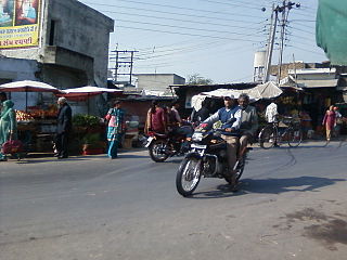
Sidhi is a town and a municipality in Sidhi district in the Indian state of Madhya Pradesh. It is the headquarters of the Sidhi district.
Pithampur is a town near Dhar city in the Dhar district of Madhya Pradesh, India. Pithampur is an industrial city, and is a part of Indore Metropolitan Region. Pithampur houses major industries and companies of Madhya Pradesh.
Paonta Sahib is an industrial town of Himachal Pradesh in India. It is located in the south of Sirmaur district, on National Highway 72. Paonta Sahib is an important place of worship for Sikhs, hosting a large Gurdwara named Gurudwara Paonta Sahib, on the banks of the river Yamuna. The river is the boundary between the states of Himachal Pradesh and Uttarakhand.
Jobat is a city and a nagar parishad municipality in Alirajpur district in the Indian state of Madhya Pradesh.
Daurala is a town and a nagar panchayat in Meerut district in the state of Uttar Pradesh, India.
Garhdiwala is a town and a municipal council in Hoshiarpur district in the state of Punjab, India.
Garoth is a town in Madhya Pradesh state in central India. It is one of the tehsil of Mandsaur District.It shares boundary with Jhalawar district of Rajasthan.The local Language spoken here is a mixture of Mewari, Harauti and Malwi Languages.
Ghansor is a small census town in Seoni district in the state of Madhya Pradesh. It serves the headquarters for Janpad panchayat Ghansor. It hosts a railway station which is in the South Eastern Central Railways zone connecting Jabalpur and Balaghat. It has a government community health centre and has a robust government education centre with a network of schools and colleges both private and public. It is well connected with bus services from Lakhnadon, Seoni, Jabalpur and Mandla. Examples of recorded temperature conditions are; the lowest temperature has been -4°C on a winter night at 3:00 am in 2018, and the highest temperature has been 52°C at 3.00 pm in summer, 2016.
Nautanwa is a town and Nagar Palika in Maharajganj district in the state of Uttar Pradesh, India. It is about 87 km from Gorakhpur, NH24 and 68 km NH730 from Maharajganj and 7 km from Sonauli Indo-Nepal Border.
Gohand is a town and a nagar panchayat in Hamirpur district in the Indian state of Uttar Pradesh. It is situated on UP-SH-21 15 km from Rath & 40 km from Orai
Gulaothi is a town, near Bulandshahr city and municipal board in the Bulandshahr district that falls under the Meerut division of the Indian state of Uttar Pradesh.

Gummidipoondi is an industrial town in Chennai Metropolitan Region of Thiruvallur district in the Indian state of Tamil Nadu. Notably, it is the northernmost assembly constituency and settlement in the state of Tamil Nadu.
Mahona is a town and a nagar panchayat in Lucknow district in the Indian state of Uttar Pradesh.
Mungaoli is a town and a nagar panchayat in Ashoknagar district in the Indian state of Madhya Pradesh. It is situated on the Bina-Kota railway line. Ganesh Shankar Vidhyarti has taken the Education from Mungaoli. It is situated near the Historic Place Chanderi & Chanderi has just 38 km away from Mungaoli.
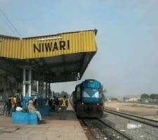
Niwari is a town and a nagar panchayat in Niwari district in Indian state of Madhya Pradesh. It is administrative headquarter of Niwari district. It is adjacent to the Jhansi and Mahoba districts of Uttar Pradesh.
Tikri is a town and a nagar panchayat in Baghpat in the Indian state of Uttar Pradesh.
Aron is a town and a nagar panchayat in Guna district in the state of Madhya Pradesh, India.
Patan is a town and a nagar panchayat in Jabalpur district in the Indian state of Madhya Pradesh. Patan is 30 km from Jabalpur on State Highway 37A which connects Damoh to Jabalpur.
Rajesultanpur or Raje Sultanpur is a town and nagar panchayat in Ambedkar Nagar district in the Indian state of Uttar Pradesh.

Bisauri is a village of the Jaunpur district, Uttar Pradesh, Northern India. Bisauri's Postal Index Number is 222129 and its post office is at Patrahi. The village is also a Gram Panchayat, comprising itself and the village of Tiwaripur.

