Ashdod is the sixth-largest city in Israel. Located in the country's Southern District, it lies on the Mediterranean coast 32 kilometres south of Tel Aviv and 20 km (12 mi) north of Ashkelon. Ashdod's port is the largest in Israel, handling 60% of the country's imported goods.

Isdud was a Palestinian village, on the site today known as Tel Ashdod. In the 1940s the village had thousands of Arab and Jewish inhabitants, but was largely depopulated in the 1948 Arab-Israeli War. By 1992, only ruins remained.

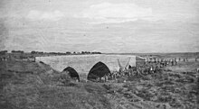
Ad Halom is a site at the eastern entrance to the city of Ashdod, Israel, where three bridges cross the Lakhish River.

Gesher is a kibbutz in the Beit She'an Valley in northeastern Israel. Founded in 1939 by Jewish refugees from Germany, it falls under the jurisdiction of Valley of Springs Regional Council. It is situated 10 km south of kibbutz Deganya Aleph and 15 km south of Tiberias. The population is approximately 500 inhabitants.
Jisr ash-Shughūr, known in antiquity as Seleucobelus, is a city in the Idlib Governorate in northwestern Syria. Situated at an altitude of 170 metres (560 ft) above sea level on the Orontes river, the city was inhabited by 44,322 people as of 2010. The inhabitants are mostly Sunni Muslims, with a significant Christian minority, mostly Greek Orthodox.
Darkush is a town in northern Syria, administratively part of the Idlib Governorate, located northwest of Idlib along the Syrian–Turkish borders on the Orontes River. Nearby localities include al-Janudiyah, Zarzur and al-Najiyah to the southwest, Jisr al-Shughur to the south and Millis and Maarrat Misrin to the east. According to the Syria Central Bureau of Statistics, Darkush had a population of 5,295 in the 2004 census. The town is also the administrative center of the Darkush nahiyah which consists of 19 villages with a combined population of 23,022. Its inhabitants are predominantly Sunni Muslims.

The Daughters of Jacob Bridge is a bridge that spans the last natural ford of the Jordan River between the Korazim Plateau in northern Israel and the Golan Heights.

The Great Mosque of Gaza, also known as the Great Omari Mosque, was the largest and oldest mosque in all of Gaza, Palestine, located in Gaza City.

Lajjun was a large Palestinian Arab village located 16 kilometers (9.9 mi) northwest of Jenin and 1 kilometer (0.62 mi) south of the remains of the biblical city of Megiddo. The Israeli kibbutz of Megiddo, Israel was built 600 metres north-east of the depopulated village on the hill called Dhahrat ed Dar from 1949.

Operation Pleshet was an Israeli military action near the village of Isdud from May 29 to June 3, 1948 during the 1948 Arab–Israeli War. Isdud was on the Israeli southern front against the Egyptian Army, and the operation was aimed at capturing the village and stopping the Egyptian advance northwards. While only the June 2–3 engagements are officially named Operation Pleshet, the events immediately preceding are historiographically joined with it.

Tel Aviv Promenade runs along the Mediterranean seashore in Tel Aviv, Israel.

The architecture of Palestine covers a vast historical time frame and a number of different styles and influences over the ages. The urban architecture of the region of Palestine prior to 1850 was relatively sophisticated. The Palestinian townhouse shared in the same basic conceptions regarding the arrangement of living space and apartment types commonly seen throughout the Eastern Mediterranean. The rich diversity and underlying unity of the architectural culture of this wider region stretching from the Balkans to North Africa was a function of the exchange fostered by the caravans of the trade routes, and the extension of Ottoman rule over most of this area, beginning in the early 16th century through until the end of World War I.

Jisr Jindas, Arabic for "Jindas Bridge", also known as Baybars Bridge, was built in 1273 CE. It crosses a small wadi, known in Hebrew as the Ayalon River, on the old road leading south to Lod and Ramla. The bridge is named after the historic village of Jindas, which stood east of the bridge. It is the most famous of the several bridges erected by Sultan Baybars in Palestine, which include the Yibna and the Isdud bridges.

The Yibna Bridge or Nahr Rubin Bridge is a Mamluk arch bridge near Yibna, which crosses the Nahal Sorek. It was previously used by Route 410 to Rehovot, and was known as the Jumping Bridge due to a bump in the middle of the bridge which caused cars to jump if speeding. It is now a part of a recreation ground, next to a new bridge carrying the Route 410.
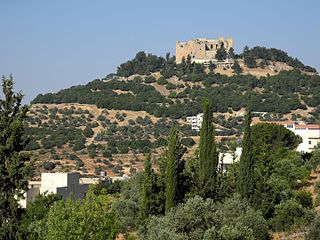
Ajloun Castle, medieval name Qalʻat ar-Rabad, is a 12th-century Muslim castle situated in northwestern Jordan. It is placed on a hilltop belonging to the Mount Ajloun district, also known as Jabal 'Auf after a Bedouin tribe which had captured the area in the 12th century. From its high ground the castle was guarding three wadis which descend towards the Jordan Valley. It was built by the Ayyubids in the 12th century and enlarged by the Mamluks in the 13th.

The Road of the Patriarchs or Way of the Patriarchs is an ancient north–south route traversing the land of Israel and the region of Palestine. The modern Highway 60 (Israel-Palestine) follows roughly the route of the Way of the Patriarchs. The name is used by biblical scholars because of mentions in biblical narratives that it was frequently travelled by Abraham, Isaac and Jacob.

The Damiyah Bridge, known as Prince Muhammad Bridge in Jordan, and as Gesher Adam in Israel, is a historical bridge that crosses the Jordan River and located between the Palestinian territories and the town of Damia in the Balqa Governorate in Jordan.
The Lod–Ashkelon railway is a railway line linking Lod and Ashkelon. It is operated by Israel Railways, and spans approximately 50 km of mostly double track in central and southern Israel.

Jisr el-Majami or Jisr al-Mujamieh is an ancient stone bridge, possibly of Roman origin, over the Jordan River on the border between Israel and Jordan. The name is derived from the bridge's location 200 m (660 ft) south of the confluence of the Yarmouk and Jordan rivers.

Ashdod or Azotus was an ancient Levantine metropolis situated at Tel Ashdod, 'Mound of Ashdod', an archaeological site located a few kilometers south of the modern Ashdod in present-day Israel.