
Roxbury is a neighborhood within the City of Boston, Massachusetts, United States.
Jamaica Plain is a neighborhood of 4.4 square miles (11 km2) in Boston, Massachusetts, United States. Settled by Puritans seeking farmland to the south, it was originally part of Roxbury. The community seceded from Roxbury during the formation of West Roxbury in 1851 and became part of Boston when West Roxbury was annexed in 1874. In the 19th century, Jamaica Plain became one of the first streetcar suburbs in America and home to a significant portion of Boston's Emerald Necklace of parks, designed by Frederick Law Olmsted.

Thomas Dudley was a New England colonial magistrate who served several terms as governor of the Massachusetts Bay Colony. Dudley was the chief founder of Newtowne, later Cambridge, Massachusetts, and built the town's first home. He provided land and funds to establish the Roxbury Latin School and signed Harvard College's new charter during his 1650 term as governor. Dudley was a devout Puritan who opposed religious views not conforming with his. In this, he was more rigid than other early Massachusetts leaders like John Winthrop, but less confrontational than John Endecott.

The North End is a neighborhood of Boston, Massachusetts, United States. It is the city's oldest residential community, having been inhabited since it was colonized in the 1630s. It is only 0.36 square miles (0.93 km2), yet the neighborhood has nearly one hundred establishments and a variety of tourist attractions. It is known for its Italian American population and Italian restaurants.

Dorchester is a neighborhood comprising more than 6 square miles (16 km2) in the City of Boston, Massachusetts, United States. Originally, Dorchester was a separate town, founded by Puritans who emigrated in 1630 from Dorchester, Dorset, England, to the Massachusetts Bay Colony. This dissolved municipality, Boston's largest neighborhood by far, is often divided by city planners in order to create two planning areas roughly equivalent in size and population to other Boston neighborhoods.

The Old South Meeting House is a historic Congregational church building located at the corner of Milk and Washington Streets in the Downtown Crossing area of Boston, Massachusetts, built in 1729. It gained fame as the organizing point for the Boston Tea Party on December 16, 1773. Five thousand or more colonists gathered at the Meeting House, the largest building in Boston at the time.

The Freedom Trail is a 2.5-mile-long (4.0 km) path through Boston that passes by 16 locations significant to the history of the United States. It winds from Boston Common in downtown Boston, to the Old North Church in the North End and the Bunker Hill Monument in Charlestown. Stops along the trail include simple explanatory ground markers, graveyards, notable churches and buildings, and a historic naval frigate. Most of the sites are free or suggest donations, although the Old South Meeting House, the Old State House, and the Paul Revere House charge admission. The Freedom Trail is overseen by the City of Boston's Freedom Trail Commission and is supported in part by grants from various non-profit organizations and foundations, private philanthropy, and Boston National Historical Park.

Melnea Agnes Cass was an American community and civil rights activist. She was deeply involved in many community projects and volunteer groups in the South End and Roxbury neighborhoods of Boston and helped found the Boston local of the Brotherhood of Sleeping Car Porters. She was active in the fight to desegregate Boston public schools, as a board member and as president of the Boston chapter of the National Association for the Advancement of Colored People (NAACP). As a young woman, Cass also assisted women with voter registration after the passage of the Nineteenth Amendment. She was affectionately known as the "First Lady of Roxbury."
This is a list of historic sites in Framingham, Massachusetts. There are several notable historic sites in Framingham, according to the Framingham Historical Society. This local society asserts:
While there are many historic spaces in Framingham, the Centre Common is the focal point for the town's past. Three of the town's most historic buildings on the Centre Common face "demolition by neglect." The Village Hall, the Edgell Memorial Library, and the Old Academy building not only house over 10,000 artifacts spanning four centuries of the town's history, but they are symbols of Framingham's commitment to educational excellence, civic engagement, and community pride.

The 1767 Milestones are historic milestones located along the route of the Upper Boston Post Road between the cities of Boston and Springfield in Massachusetts. The 40 surviving milestones were added to the National Register of Historic Places in 1971. Massachusetts has a total of 129 surviving milestones including those along the upper Post Road. The stones are so named, despite having been placed in many different years, because of a 1767 directive of the Province of Massachusetts Bay that such stones be placed along major roadways. The state highway department was directed in 1960 to undertake their preservation. Many of them underwent a major restoration in 2018.

Charles Street African Methodist Episcopal Church is an historic African Methodist Episcopal Church at 551 Warren Street in Boston, Massachusetts. The current church building was built in 1888 by J. Williams Beal and added to the National Register of Historic Places in 1983.

Eliot Burying Ground is a historic seventeenth-century graveyard at Eustis and Washington Streets in the Roxbury neighborhood of Boston, Massachusetts. It occupies a roughly triangular lot of 0.8 acres (0.32 ha).
The Eliot Congregational Church is a historic Congregational church at 56 Dale Street, at the corner of Walnut Avenue in the Roxbury neighborhood of Boston, Massachusetts.

The Dillaway School is an historic school at 16-20 Kenilworth Street in Boston, Massachusetts. The school was built in 1882 to a design by George Albert Clough, the city's first official architect, and is his only surviving school design in the city. The building was listed on the National Register of Historic Places in 1980, and included in the Roxbury Highlands Historic District in 1989. The building has been converted to residential use.
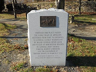
The Henry Knox Trail, also known as the Knox Cannon Trail, is a network of roads and paths that traces the route of Colonel Henry Knox's "noble train of artillery" from Crown Point to the Continental Army camp outside Boston, Massachusetts early in the American Revolutionary War.

The noble train of artillery, also known as the Knox Expedition, was an expedition led by Continental Army Colonel Henry Knox to transport heavy weaponry that had been captured at Fort Ticonderoga to the Continental Army camps outside Boston during the winter of 1775–76.

Stony Brook Reservation is a woodland park in Boston and Dedham, Massachusetts, a unit of the Metropolitan Park System of Greater Boston, part of the state park system of Massachusetts. It was established in 1894 as one of the five original reservations created by the Metropolitan Park Commission. The park is served by the Stony Brook Reservation Parkways, a road system that was entered into the National Register of Historic Places in 2006.

Roxbury Heritage State Park is a history-themed heritage park in the oldest part of Roxbury, a former town annexed in 1868 by Boston, Massachusetts. It is anchored by the Dillaway–Thomas House, a large colonial structure built in 1750 and thought to be the oldest surviving house in Roxbury. The location includes an adjacent 1-acre (0.40 ha) landscaped park with views of the Boston skyline, and is part of the Metropolitan Park System of Greater Boston.

Fort Hill is a 0.4 square mile neighborhood and historic district of Roxbury, in Boston, Massachusetts. The approximate boundaries of Fort Hill are Malcolm X Boulevard on the north, Washington Street on the southeast, and Columbus Avenue on the southwest.
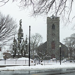
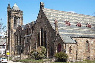
The First Church in Roxbury, also known as the First Church of Roxbury is the current headquarters of the Unitarian Universalist ("UU") Urban Ministry. A church on this site has been in use since 1632 when early English settlers built the first meetinghouse. Since then, the meetinghouse has been rebuilt four times, and its appearance today reflects how the meetinghouse looked in the late 19th and early 20th centuries.


