Johnstone Street, Bath

Last updated

Johnstone Street
Johnstone Street, Bath.JPG
Location Bath, Somerset, England
Coordinates 51°22′59″N2°21′21″W / 51.38306°N 2.35583°W / 51.38306; -2.35583 Coordinates: 51°22′59″N2°21′21″W / 51.38306°N 2.35583°W / 51.38306; -2.35583
Builtc. 1790
Architect Thomas Baldwin
Listed Building – Grade I
Official nameNumber 1 to 15
Designated12 June 1950 [1]
Reference no.442703
Somerset UK location map.svg
Red pog.svg
Location of Johnstone Street in Somerset

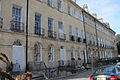
Johnstone Street in the Bathwick area of Bath, Somerset, England was designed in 1788 by Thomas Baldwin, with some of the buildings being completed around 1805-1810 by John Pinch the elder.

Contents

Number 1 was built in 1794 with numbers 2 to 8 being completed around 1805, [2] with numbers 9 to 15 being completed between 1794 and 1801. [3]

The terrace proves a consistent style of three storey houses, which complement the surrounding Georgian buildings and layout of Laura Place, Great Pulteney Street and Henrietta Street. [1]

William Pitt lived at number 15 in 1802. [1]

See also

Related Research Articles

<span class="mw-page-title-main">Bath, Somerset</span> City in Somerset, England

Bath is a city in the Bath and North East Somerset unitary area in the county of Somerset, England, known for and named after its Roman-built baths. At the 2021 Census, the population was 101,557. Bath is in the valley of the River Avon, 97 miles (156 km) west of London and 11 miles (18 km) southeast of Bristol. The city became a World Heritage Site in 1987, and was later added to the transnational World Heritage Site known as the "Great Spa Towns of Europe" in 2021. Bath is also the largest city and settlement in Somerset.

<span class="mw-page-title-main">Pulteney Bridge</span> Bridge over the River Avon in Bath, England

Pulteney Bridge is a bridge over the River Avon in Bath, England. It was completed by 1774, and connected the city with the land of the Pulteney family which it wished to develop. Designed by Robert Adam in a Palladian style, it is highly unusual in that it has shops built across its full span on both sides. It has been designated as a Grade I listed building.

<span class="mw-page-title-main">Dunster</span> Human settlement in England

Dunster is a village and civil parish in Somerset, England, within the north-eastern boundary of Exmoor National Park. It lies on the Bristol Channel 2.5 miles (4 km) southeast of Minehead and 20 miles (32 km) northwest of Taunton. At the 2011 Census, it had a population of 817.

John Palmer was an English architect who worked on some of the notable buildings in the city of Bath, Somerset, UK. He succeeded Thomas Baldwin as City Architect in 1792. He died in Bath.

Thomas Baldwin was an English architect in the city of Bath, who was responsible for designing some of Bath's principal Georgian buildings.

<span class="mw-page-title-main">Jane Austen Centre</span> Building in England

The Jane Austen Centre at 40 Gay Street in Bath, Somerset, England, is a permanent exhibition which tells the story of Jane Austen's Bath experience, and the effect that visiting and living in the city had on her and her writing.

<span class="mw-page-title-main">Grade I listed buildings in Somerset</span> Buildings of exceptional interest in Somerset

The Grade I listed buildings in Somerset, England, demonstrate the history and diversity of its architecture. The ceremonial county of Somerset consists of a non-metropolitan county, administered by Somerset County Council, which is divided into five districts, and two unitary authorities. The districts of Somerset are West Somerset, South Somerset, Taunton Deane, Mendip and Sedgemoor. The two administratively independent unitary authorities, which were established on 1 April 1996 following the breakup of the county of Avon, are North Somerset and Bath and North East Somerset. These unitary authorities include areas that were once part of Somerset before the creation of Avon in 1974.

<span class="mw-page-title-main">Grade I listed buildings in Bath and North East Somerset</span>

Bath and North East Somerset is a unitary authority created on 1 April 1996, following the abolition of the County of Avon, which had existed since 1974. Part of the ceremonial county of Somerset, Bath and North East Somerset occupies an area of 220 square miles (570 km2), two-thirds of which is green belt. It stretches from the outskirts of Bristol, south into the Mendip Hills and east to the southern Cotswold Hills and Wiltshire border. The city of Bath is the principal settlement in the district, but BANES also covers Keynsham, Midsomer Norton, Radstock and the Chew Valley. The area has a population of 170,000, about half of whom live in Bath, making it 12 times more densely populated than the rest of the area.

<span class="mw-page-title-main">Guildhall, Bath</span> Municipal building in Bath, Somerset, England

Guildhall is an 18th-century municipal building in central Bath, Somerset, England. It is a Grade I listed building.

<span class="mw-page-title-main">Gay Street, Bath</span> Historic site in Somerset, England

Gay Street in Bath, Somerset, England, links Queen Square to The Circus. It was designed by John Wood, the Elder in 1735 and completed by his son John Wood, the Younger. The land was leased to the elder Wood by Robert Gay, MP for Bath, and the street is named after him. Much of the road has been designated as Grade I listed buildings.

<span class="mw-page-title-main">North Parade, Bath</span> Street in Bath and North East Somerset, United Kingdom

North Parade in Bath, Somerset, England is a historic terrace built around 1741 by John Wood, the Elder. Several of the houses have been designated as Grade I listed buildings.

<span class="mw-page-title-main">South Parade, Bath</span> Historic site in Somerset, England

South Parade in Bath, Somerset, England, is a historic terrace built around 1743 by John Wood, the Elder. All of the houses have been designated as Grade I listed buildings.

<span class="mw-page-title-main">Stall Street, Bath</span> Historic site in Somerset, England

Stall Street in Bath, Somerset, England was built by John Palmer between the 1790s and the first decade of the 19th century. The buildings which form an architectural group have listed building status and are now occupied by shops and offices.

<span class="mw-page-title-main">The Paragon, Bath</span> Grade I listed street in Bath, England

The Paragon in the Walcot area of Bath, Somerset, England is a street of Georgian houses which have been designated as listed buildings. It was designed by Thomas Warr Attwood. It now forms part of the A4.

<span class="mw-page-title-main">Henrietta Street, Bath</span> Historic site in Somerset, England

Henrietta Street in the Bathwick area of Bath, Somerset, England was built around 1785 by Thomas Baldwin.

<span class="mw-page-title-main">Buildings and architecture of Bath</span> Permanent structures including significant examples of English architecture from the Roman Baths

The buildings and architecture of Bath, a city in Somerset in the south west of England, reveal significant examples of the architecture of England, from the Roman Baths, to the present day. The city became a World Heritage Site in 1987, largely because of its architectural history and the way in which the city landscape draws together public and private buildings and spaces. The many examples of Palladian architecture are purposefully integrated with the urban spaces to provide "picturesque aestheticism". In 2021, the city was added to a second World Heritage Site, a group of historic spa towns across Europe known as the "Great Spas of Europe". Bath is the only entire city in Britain to achieve World Heritage status, and is a popular tourist destination.

<span class="mw-page-title-main">Sydney Gardens</span> Public open space in Bath, England

Sydney Gardens is a public open space at the end of Great Pulteney Street in Bath, Somerset, England. The gardens are the only remaining eighteenth-century pleasure gardens in the country. They are Grade II listed on the Register of Historic Parks and Gardens of special historic interest in England.

<span class="mw-page-title-main">Argyle Street, Bath</span> Historic site in Somerset, England

Argyle Street is a historic street in the centre of Bath, England located between Pulteney Bridge and Laura Place.

<span class="mw-page-title-main">Scheduled monuments in Somerset</span> Nationally important sites in Somerset, England

There are over 670 scheduled monuments in the ceremonial county of Somerset in South West England. The county consists of a non-metropolitan county, administered by Somerset County Council, which is divided into five districts, and two unitary authorities. The districts of Somerset are West Somerset, South Somerset, Taunton Deane, Mendip and Sedgemoor. The two administratively independent unitary authorities, which were established on 1 April 1996 following the breakup of the county of Avon, are North Somerset and Bath and North East Somerset. These unitary authorities include areas that were once part of Somerset before the creation of Avon in 1974.

<span class="mw-page-title-main">The Crescent, Taunton</span> Street in Taunton, United Kingdom

The Crescent is a street in Taunton, a town in the English county of Somerset. Construction began in 1807, during a period of extensive redevelopment in the town, driven by the Market House Society and the Member of Parliament Sir Benjamin Hammet. Lined on the eastern side by a Georgian terrace, the street follows a shallow crescent shape, broken in the middle by Crescent Way and a bit further south by St George's Place. It links Upper High Street, at its southern end, with Park Street and Tower Street to the north. On the western side, Somerset County Council have their offices in the County Hall, erected in 1935, and extended in the 1960s. The Georgian terrace, the Masonic Hall, and the County Hall are recorded in the National Heritage List for England as listed buildings.

References

  1. 1 2 3 "Johnstone Street". Images of England. English Heritage. Archived from the original on 18 October 2012. Retrieved 30 August 2009.
  2. Historic England. "1-8 Johnstone Street (1395919)". National Heritage List for England . Retrieved 4 April 2015.
  3. Historic England. "9-15 Johnstone Street (1395920)". National Heritage List for England . Retrieved 4 April 2015.