Related Research Articles

Warren County is a county located in the U.S. state of New Jersey. According to the 2020 census, the county was the state's 19th-most populous county, with a population of 109,632, its highest decennial count ever and an increase of 940 (+0.9%) from the 2010 census count of 108,692, which in turn reflected an increase of 6,255 (+6.1%) from 102,437 counted at the 2000 census. The county is part of the North Jersey region of the state.

Sussex County is the northernmost county in the U.S. state of New Jersey. Its county seat is Newton. It is part of the New York metropolitan area and is part of New Jersey's Skylands Region. As of the 2020 census, the county was the state's 17th-most-populous county, with a population of 144,221, a decrease of 5,044 (−3.4%) from the 2010 census count of 149,265, which in turn reflected an increase of 5,099 (+3.5%) over the 144,166 persons at the 2000 census. Based on 2020 census data, Vernon Township was the county's largest in both population and area, with a population of 22,358 and covering an area of 70.59 square miles (182.8 km2). The county is part of the North Jersey region of the state.

Newton, officially the Town of Newton, is an incorporated municipality and the county seat of Sussex County in the U.S. state of New Jersey, situated approximately 60 miles (97 km) northwest of New York City. As of the 2020 United States census, the town's population was 8,374, its highest decennial population ever, an increase of 377 (+4.7%) from the 2010 census count of 7,997, which in turn reflected a decrease of 247 (−3.0%) from the 8,244 counted in the 2000 census.

Route 94 is a state highway in the northwestern part of New Jersey, United States. It runs 45.9 mi (73.87 km) from the Portland–Columbia Toll Bridge over the Delaware River in Knowlton Township, Warren County, where it connects to PA 611, northeast to the New York state line in Vernon, Sussex County. At the New York border, NY 94 continues to Newburgh, New York. Route 94 is mostly a two-lane undivided road that runs through mountain and valley areas of Warren and Sussex counties, serving Columbia, Blairstown, Newton, and Hamburg. The route intersects several roads, including US 46 and I-80 in Knowlton Township, US 206 in Newton, Route 15 in Lafayette Township, and Route 23 in Hamburg.

The Delaware Valley, sometimes referred to as Greater Philadelphia or the Philadelphia metropolitan area, is a major metropolitan region in the Northeast United States that centers around Philadelphia, the nation's sixth-most populous city, and spans parts of four U.S. states: southeastern Pennsylvania, southern New Jersey, northern Delaware, and the northern Eastern Shore of Maryland. With a core metropolitan statistical area population of 6.288 million residents and a combined statistical area population of 7.366 million as of the 2020 census, the Delaware Valley is the eighth-largest metropolitan region in the United States and the 68th-largest metropolitan region in the world.
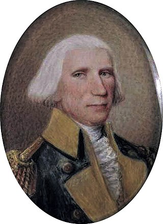
Elias Dayton was an American merchant and military officer who served as captain and colonel of the local militia and in 1783 rose to become a brigadier general during the American Revolutionary War. Afterward, he became the Mayor of Elizabethtown, New Jersey and served in the New Jersey General Assembly. He was the father of U.S. Constitution signer Jonathan Dayton.

The Paulins Kill is a 41.6-mile (66.9 km) tributary of the Delaware River in northwestern New Jersey in the United States. With a long-term median flow rate of 76 cubic feet of water per second (2.15 m3/s), it is New Jersey's third-largest contributor to the Delaware River, behind the Musconetcong River and Maurice River. The river drains an area of 176.85 square miles (458.0 km2) across portions of Sussex and Warren counties and 11 municipalities. It flows north from its source near Newton, and then turns southwest. The river sits in the Ridge and Valley geophysical province.
The 1st New Jersey Regiment was the first organized militia regiment in New Jersey, formed in 1673 in Piscataway "to repel foreign Indians who come down from upper Pennsylvania and western New York to our shores and fill (themselves) with fishes and clams and on the way back make a general nuisance of themselves by burning hay stacks, corn fodder and even barns." The first commander and founder of the regiment was Captain Francis Drake (1615-1687) who served from 1673 to 1685. All of New Jersey's regular organized military forces trace their lineage to this first provincial militia unit.
The 2nd New Jersey Regiment was raised, on 9 October 1775, at Trenton, New Jersey, for service with the Continental Army under the command of Colonel William Maxwell. The regiment would see action at the Battle of Trois-Rivières, Battle of Valcour Island, Battle of Brandywine, Battle of Germantown, Battle of Crooked Billet, Battle of Monmouth, Sullivan Expedition, Battle of Springfield and the Battle of Yorktown. The regiment was furloughed, on 6 June 1783, at Newburgh, New York, and disbanded 3 November 1783.
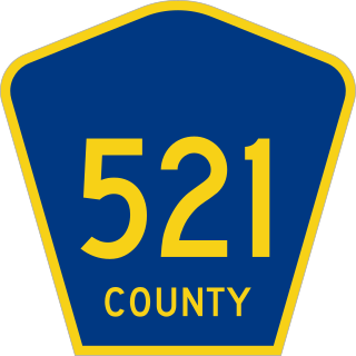
County Route 521 is a county highway in the U.S. state of New Jersey. The highway extends 43.71 miles from High Street in Hope Township to the New York state line in Montague Township.

County Route 519 is a county highway in the U.S. state of New Jersey. The highway extends 88.54 miles (142.49 km) from Daniel Bray Highway in Delaware Township to the New York state line in Wantage Township. It is the state's longest county route.
The Military Road was a roadway built in the present-day U.S. state of New Jersey during the French and Indian War connecting Elizabethtown with a string of fortifications along the Delaware River in modern Sussex and Warren Counties in northwestern New Jersey. The road was conceived and built under the order of Jonathan Hampton, Esq., an Elizabethtown merchant and surveyor who was appointed as Victualer and Paymaster to the New Jersey Frontier Guard by an act of the New Jersey's colonial legislature.
The Frontier Guard was a provincial military unit organized by New Jersey's colonial legislature in 1755 to man a series of frontier fortifications along the Delaware River in northwestern New Jersey. Members were paid two shillings per day, provincial currency, and were supposed to provide their own firelock, blanket, hatchet or cutlass, cartridge box, knapsack or haversack, and powder horn. As the Province had spent its available funds in equipping the Jersey Blues, the Frontier Guard was not a uniformed unit.

Fort Mercer was an earthen fort on the eastern shores of the Delaware River in New Jersey that was constructed by the Continental Army during the American Revolutionary War. The fort was built in 1777 by Polish engineer Thaddeus Kosciuszko under the command of George Washington. Along with Fort Mifflin on the Pennsylvania side of the Delaware River to its west, Fort Mercer was designed to block the British advance on the revolutionary capital of Philadelphia during the Philadelphia campaign.
Fort Pleasant — formerly known as Fort Van Meter and Town Fort and still also known as the Isaac Van Meter House — is a historic site located near the unincorporated community of Old Fields about 5 miles north of Moorefield in Hardy County, West Virginia, U.S. Situated on the South Branch Potomac River, a young Colonel George Washington directed a fortification to be built here in 1756 during the escalating hostilities with Native Americans and French known as the French and Indian War. The fierce skirmish known as the Battle of the Trough occurred about a mile and a half away the same year. The existing Federal style house, built just after the American Revolution, was listed on the National Register of Historic Places in 1973.

Van Campen's Inn or Isaac Van Campen Inn is a fieldstone residence that was used as a yaugh house during the American colonial era. Located in Walpack Township, Sussex County, New Jersey along the Delaware River, it is a historic site located along the Old Mine Road in the Delaware Water Gap National Recreation Area. It is operated under a memorandum of understanding between the National Park Service and the Walpack Historical Society, a local non-profit corporation.
The history of Sussex County, New Jersey spans over 13,000 years from the time Paleo Indians arrived after the Wisconsin glacier melted to the present day, and the entire width of the American experience.

Christ Church, also known as Christ Episcopal Church, is a Christian house of worship located on the corner of Church Street and Main Street in Newton, New Jersey. It is a parish overseen by the Episcopal Diocese of Newark, a diocese of the Episcopal Church in the United States of America. The congregation first met on 28 December 1769 and was granted a charter by New Jersey's last Royal Governor William Franklin on behalf of Britain's King George III. Christ Church is the oldest church in Newton and the third oldest parish in the Diocese of Newark.

Bevans, also known as Peters Valley, is an unincorporated community located at the intersection of Bevans Road, Walpack Road, and Kuhn Road in Sandyston Township of Sussex County, New Jersey. The village is now part of the Delaware Water Gap National Recreation Area. Both the Delaware River and the Old Mine Road are nearby.
References
- ↑ Lurie, Maxine N. Lurie; and Mappen, Mar. "Hampton Township", entry in Encyclopedia of New Jersey , p. 348. Rutgers University Press, 2004. ISBN 0-8135-3325-2. Accessed March 13, 2013.