Jones Beach Island

Last updated
Jones Beach Island Wpdms ev26188 jones beach island.jpg
Jones Beach Island

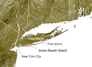
Jones Beach Island is one of the outer barrier islands off the southern coast of Long Island in the U.S. state of New York.

Contents

Etymology

It is named for Major Thomas Jones, who first came to Long Island in 1692, where he proceeded to build the island's first brick house near Massapequa. Jones built a whaling station on Jones Island near the present site of Jones Beach State Park in 1700. [1]

Jones Beach Island is sometimes referred to as Oak Beach Island and is the former home of the infamous Oak Beach Inn. [2] Because of the ephemeral nature of the various inlets, the name Fire Island is sometimes used to refer collectively to the various barrier islands off the south shore of Long Island, but usually refers specifically to the island across the Fire Island Inlet to the east. [3]

Geography

Jones Beach Island is separated from Long Island by South Oyster Bay and Great South Bay, from Long Beach Barrier Island by Jones Inlet to the west, and from Fire Island by Fire Island Inlet to the east. It straddles the line between Nassau and Suffolk counties. [3]

From west to east, Jones Beach Island contains the following communities and parks:

The southern side of the island is known for its beaches that face the open Atlantic Ocean. The best known of the public beaches on the island, [6] Jones Beach State Park on the western tip of the island, is a summer recreational destination for the New York City area. [7]

Jones Beach Island is accessible from Long Island on its western end by the Meadowbrook State Parkway to Merrick (with the Loop Parkway providing a spur to Long Beach), and the Wantagh State Parkway to Wantagh. The Robert Moses Causeway traverses its eastern end, linking to Babylon via the State Boat Channel Bridge and Great South Bay Bridge, as well as to Fire Island by the Fire Island Inlet Bridge. The Ocean Parkway connects all three causeways and runs the length of the island. [7]

Related Research Articles

<span class="mw-page-title-main">Babylon, New York</span> Town in New York, United States

The Town of Babylon is one of ten towns in Suffolk County, New York, United States. Its population was 218,223 as of the 2020 census. Parts of Jones Beach Island, Captree Island and Fire Island are in the southernmost part of the town. It borders Nassau County to the west and the Atlantic Ocean to the south. At its westernmost point, it is about 20 miles (32 km) from New York City at the Queens border, and about 30 miles (48 km) from Manhattan. The village of Babylon is also within the town.

<span class="mw-page-title-main">Great South Bay</span>

The Great South Bay is a lagoon situated between Long Island and Fire Island, in the State of New York. It is about 45 miles (72 km) long and has an average depth of 4 feet 3 inches (1.3 m) and is 20 feet (6.1 m) at its deepest. It is protected from the Atlantic Ocean by Fire Island, a barrier island, as well as the eastern end of Jones Beach Island and Captree Island.

<span class="mw-page-title-main">Robert Moses Causeway</span>

The Robert Moses Causeway is an 8.10-mile-long (13.04 km) parkway in Suffolk County, New York on Long Island. It is named for the master builder and urban planner Robert Moses. The parkway, originally known as the Captree Causeway, connects West Islip on Long Island to the barrier beach islands, such as Captree Island, Jones Beach Island, and the western tip of Fire Island, to the south. It is designated New York State Route 908J (NY 908J), an unsigned reference route.

<span class="mw-page-title-main">West Gilgo Beach, New York</span>

West Gilgo Beach is a small private gated community located in the town of Babylon, in Suffolk County, New York, United States. It is part of the Gilgo census-designated place.

<span class="mw-page-title-main">Captree State Park</span> State park in New York, United States

Captree State Park is a 340-acre (1.4 km2) state park located in the towns of Babylon and Islip in Suffolk County, New York, United States. The park is located south of Captree Island on the easternmost end of Jones Beach Island, and overlooks the Fire Island Inlet and the westernmost section of Fire Island.

<span class="mw-page-title-main">Wantagh State Parkway</span> Highway in Nassau County, New York

The Wantagh State Parkway is a 13.33-mile (21 km) controlled-access parkway on Long Island, New York, in the United States. It links the Ocean Parkway in Jones Beach State Park with the Northern State Parkway in Westbury. The parkway is located approximately 30 miles (48 km) east of Manhattan and 14 miles (23 km) east of the Nassau–Queens border.

<span class="mw-page-title-main">Ocean Parkway (Long Island)</span> Highway on Jones Beach Island, in New York

The Ocean Parkway is a 15.59-mile (25.09 km) limited-access parkway that traverses Jones Beach Island between Jones Beach State Park and Captree State Park on Long Island, New York, in the United States. It begins at the southern terminus of the Meadowbrook State Parkway and heads east across Jones Beach Island, intersecting the south end of the Wantagh State Parkway before ending just past the southern terminus of the Robert Moses Causeway. The highway is designated New York State Route 909D (NY 909D), an unsigned reference route.

<span class="mw-page-title-main">South Shore (Long Island)</span> Southern edge of Long Island in New York state

The South Shore of Long Island, in the U.S. state of New York, is the area along Long Island's Atlantic Ocean shoreline.

<span class="mw-page-title-main">New York's 2nd congressional district</span> U.S. House district for New York

New York's 2nd congressional district is a congressional district for the United States House of Representatives along the South Shore of Long Island, New York. It includes southwestern Suffolk County and a small portion of southeastern Nassau County. The district is currently represented by Republican Andrew Garbarino.

<span class="mw-page-title-main">Outer Barrier</span> String of barrier islands dividing Long Island from the Atlantic Ocean

The Outer Barrier, also known as the Long Island and New York City barrier islands, refers to the string of barrier islands that divide the lagoons south of Long Island, New York from the Atlantic Ocean. These islands include Long Beach Barrier Island, Barnum Island, Jones Beach Island, Fire Island and Westhampton Island. The outer barrier extends 75 miles (121 km) along the South Shore of Long Island, from the Rockaway Peninsula in New York City to the east end of Shinnecock Bay in Suffolk County.

<span class="mw-page-title-main">Oyster Bay, New York</span> Town in New York, United States

The Town of Oyster Bay is the easternmost of the three towns that make up Nassau County, New York, United States. Part of the New York metropolitan area, it is the only town in Nassau County to extend from the North Shore to the South Shore of Long Island. As of the 2020 census, it had a population of 301,332, Making it the 5th most populous city or town in the state.

<span class="mw-page-title-main">Oak Beach, New York</span> Census-designated place on Jones Beach Island

Oak Beach is a small community and census-designated place located near the eastern end of Jones Beach Island, a barrier island between the Atlantic Ocean and the Great South Bay of Long Island. The community is part of the village of Babylon in Suffolk County, New York, United States. The eastern part, the Oak Island Beach Association, is gated, whereas the western part is not. The Oak Beach CDP was first listed prior to the 2020 census. Prior to that the community was part of the Oak Beach–Captree census-designated place.

<span class="mw-page-title-main">Fire Island Inlet</span>

Fire Island Inlet is an inlet on the south shore of Long Island, New York.

Gilgo State Park is a 1,223-acre (4.95 km2) undeveloped state park in Gilgo, Suffolk County, New York. The park is located on Jones Beach Island, a barrier island off the southern shore of Long Island.

<span class="mw-page-title-main">State Boat Channel Bridge</span> Bridge

The State Boat Channel Bridge is a bascule bridge (drawbridge) in Suffolk County, New York, United States. It crosses over the Long Island New York State Boat Channel connecting Captree Island and Jones Beach Island on Robert Moses Causeway in the Oak Beach–Captree area within the town of Babylon.

<span class="mw-page-title-main">Tobay Beach</span>

Tobay Beach is a restricted access recreational beach located in the middle of Jones Beach Island, a barrier island off the South Shore of Long Island, Nassau County, New York, United States, within the Massapequa 11758 Zip code. Its name is a portmanteau for the Town of Oyster Bay, which owns and manages the beach. Residents of the town are allowed entry, with limited access for non-residents.

<span class="mw-page-title-main">Gilgo, New York</span> Hamlet and census-designated place in New York, United States

Gilgo is a hamlet and census-designated place (CDP) in the Town of Babylon in Suffolk County, New York, United States. The population was 185 at the time of the 2020 census.

<span class="mw-page-title-main">Oak Beach–Captree, New York</span> Census-designated place in New York, United States

Oak Beach–Captree, frequently just called Oak Beach, was a census-designated place (CDP) in the town of Babylon in Suffolk County, New York, United States. The population was 286 at the 2010 census.

Captree is a census-designated place (CDP) in the towns of Islip and Babylon in Suffolk County, New York, United States. It occupies Captree Island in Great South Bay, as well as the east end of Jones Beach Island to the south, comprising Captree State Park. It was first listed as a CDP prior to the 2020 census. Prior to that it was part of the Oak Beach–Captree CDP.

References

  1. "Jones Beach State Park: History". JonesBeach.org. Archived from the original on 2012-05-02. Retrieved 2012-11-20.
  2. "Hofstra University: Study of Beaches on Jones Beach Island". hofstra.edu. Hofstra University.
  3. 1 2 "P.L. 94-171 County Block Map (2010 Census): Suffolk County, NY" (PDF). U.S. Census Bureau. Retrieved 2012-12-28.
  4. "Photo Tour: John F. Kennedy Memorial Wildlife Sanctuary". Massapequa, NY Patch. 2010-06-17. Retrieved 2021-05-28.
  5. 1 2 3 "Ocean Beaches". Town of Babylon. Retrieved 2021-05-28.
  6. "Jones Beach State Park: History". JonesBeach.org. Archived from the original on 2012-05-02. Retrieved 2012-11-20.
  7. 1 2 Wolff, Fred; Bennington, J. Bret (April 15, 2000). Beach Profile Study of eastern Jones Beach Island and western Fire Island. Long Island Geologists Conference, SUNY Stony Brook. Hofstra University. Archived from the original on September 30, 2007.

40°35′46″N73°30′28″W / 40.596234°N 73.507861°W / 40.596234; -73.507861 (Jones Beach Island)