KH-9 (BYEMAN codename HEXAGON), commonly known as Big Bird or KeyHole-9,[1] was a series of photographicreconnaissance satellites launched by the United States between 1971 and 1986. Of twenty launch attempts by the National Reconnaissance Office (NRO), all but one were successful.[2]Photographic film aboard the KH-9 was stored on RCA Astro Electronic Division take up reel system then sent back to Earth in recoverable film return capsules for processing and interpretation. The highest ground resolution achieved by the main cameras of the satellite was 2ft (0.61m),[3] though another source says "images in the 'better-than-one-foot' category" for the last "Gambit" missions.[4]
They are officially known as the Broad Coverage Photo Reconnaissance satellites (Code 467). The satellites were built by Lockheed Corporation for the NRO.[1]
The satellites were an important factor in determining Soviet military capabilities and in the acquisition of accurate intelligence for the formulation of U.S. national policy decisions as well as deployment of U.S. forces and weapon systems. The satellites were instrumental in U.S. National Technical Means of Verification of Strategic Arms Limitation Talks (SALT) and the Anti-Ballistic Missile Treaty (ABMT).[5]
KH-9 was, according to many who worked on it, the most sophisticated mechanical satellite in history.[10] It was conceived in the early 1960s as a replacement for the CORONA search satellites. The goal was to search large areas of the Earth with a medium resolution camera. The KH-9 carried two main cameras, although a mapping camera was also carried on several missions. The photographic film from the cameras was sent to recoverable re-entry vehicles and returned to Earth, where the capsules were caught in mid-air by an aircraft. Four re-entry vehicles were carried on most missions, with a fifth added for missions that included a mapping camera.
Between September 1966 and July 1967, the contractors for the Hexagon subsystems were selected. Lockheed Missiles and Space Company (LMSC) was awarded the contract for the Satellite Basic Assembly (SBA), Perkin Elmer for the primary Sensor Subsystem (SS), McDonnell for the Reentry Vehicle (RV), RCA Astro-Electronics Division for the Film Take-Up system, and Itek for the Stellar Index camera (SI). Integration and ground-testing of Satellite Vehicle-1 (SV-1) were completed in May 1971, and it was subsequently shipped to Vandenberg Air Force Base in a 70ft (21m) container. Ultimately, four generations ("blocks") of KH-9 HEXAGON reconnaissance satellites were developed. KH9-7 (missions 7 to 12) was the first to fly a Block-II panoramic camera and SBA. Block-III (missions 13 to 18) included upgrades to electrical distribution and batteries. Two added tanks with ullage control for the Orbit Adjust System (OAS) and new thrusters for the Reaction Control System (RCS) served to increase KH-9's operational lifetime. In addition, the nitrogen supply for the film transport system and the camera vessel was increased. Block-IV (missions 19 and 20) was equipped with an extended command system using plated-wire memory.[11] In the mid 1970s, over 1,000 people in the Danbury, Connecticut area worked on the secret project.[12]
A reentry vehicle from the first Hexagon satellite sank to 16,000ft (4,900m) below the Pacific Ocean after its parachute failed. The USSTrieste II(DSV-1) retrieved its payload in April 1972 after a lengthy search, but the film had disintegrated during the nine months underwater, leaving no usable photographs.[13]
Over the duration of the program, the lifetime of the individual satellites increased steadily. The final KH-9 operated for 275 days. The satellite mass with and without the Mapping Camera System was 13,300 and 11,400kg (29,300 and 25,100lb), respectively.
NRO intended to replace HEXAGON with ZEUS, later DAMON—HEXAGON's camera flown on the Space Shuttle—but DAMON was canceled in December 1980.[10][14] In December 1976 NRO launched the first KH-11 KENNEN. While its electro-opticaldigital imaging had a smaller field of view than HEXAGON, by not needing film KENNEN was usable for years.[10]
Main KH-9 components
Satellite Control Section
Satellite Control Section
The Satellite Control Section (SCS), which forms the aft part of the SBA, started as Air Force Project 467. SCS was intended as a more capable replacement for the on-orbit propulsion, which had been provided by the Agenaupper stage for previous generations of reconnaissance satellites. The SCS featured an increased diameter of 10ft (3.0m) (compared to 5ft (1.5m) for the Agena) and a length of 6ft (1.8m). It housed hydrazine propellant tanks for the pressure fed Orbital Adjust System (OAS) and the Reaction Control System (RCS). OAS and RCS were connected by a transfer line to facilitate propellant exchange. The tank pressure was maintained within the operational range by additional high pressure nitrogen tanks. The SCS incorporated a freon gas system for backup attitude control inherited from the Agena, commonly referred to as "lifeboat".[15] SCS was equipped with deployable solar panels and an unfurlableparabolic antenna for high data rate communication.[16]
Main camera
A main camera optical pathA achieved ground resolution of Satellite Vehicles (SV) 1 to 18 main cameras.A KH-9 image of the Soviet civil Moscow Domodedovo Airport misidentified in the original document as Kubinka airfield
The main camera system was designed by Perkin-Elmer to take stereo images,[17] with a forward looking camera on the port side, and an aft looking camera on the starboard side. Images were taken at altitudes ranging from 90–200mi (480,000–1,060,000ft; 140–320km). The camera optical layout is an f/3.0 folded Wright camera, with a focal length of 60in (1,500mm). The system aperture is defined by a 20in (510mm) diameter aspheric corrector plate, which corrects the spherical aberration of the Wright design. In each of the cameras the ground image passes through the corrector plate to a 45°-angle flat mirror, which reflects the light to a 0.91m (3ft 0in)-diameter concave main mirror. The main mirror directs the light through an opening in the flat mirror and through a four-element lens system onto the film platen. The cameras could scan contiguous areas up to 120° wide, and achieved a ground resolution better than 2ft (0.61m) during the later phase of the project.[3][18]Dwayne Allen Day calculated, using disclosed specifications, that HEXAGON was capable of 0.2m (7.9in) at nadir, and 0.4m (1ft 4in) at apogee.[10]
Mapping camera
Missions 1205 to 1216 carried a "mapping camera" (also known as a "frame camera") that used 9in (230mm) film and had a moderately low resolution of initially 30ft (9.1m), which improved to 20ft (6.1m) on later missions [19] (somewhat better than LANDSAT). Intended for mapmaking, photos this camera took cover the entire Earth with images between 1973 and 1981.[20] Almost all the imagery from this camera, amounting to 29,000 images, each covering 3,400km2 (1,300sqmi), was declassified in 2002 as a result of Executive order 12951,[21] the same order which declassified CORONA, and copies of the films were transferred to the U.S. Geological Survey's Earth Resources Observation Systems office.[22]
Scientific analysis of declassified KH-9 satellite images continues to reveal historic trends and changes in climate and terrestrial geology. A 2019 study of glacial melt in the Himalayas over the past half-century used data collected by KH-9 satellites throughout the 1970s and 1980s to demonstrate that melt rates had doubled since 1975.[23]
The KH-9 was never a backup project for the KH-10 Manned Orbital Laboratory. It was developed solely as a replacement for the Corona search system.[15]
Reentry vehicles
The forward section of KH-9 housed four McDonnell Douglas Mark 8 satellite reentry vehicles (RV), which were fed film exposed by the main cameras. Each RV had an empty mass of 434kg. It housed a film take-up assembly (built by RCA Astro Electronic Division) with a mass of 108kg, and could store about 227kg of film. The twelve mapping missions were equipped with an additional General Electrics Mark V RV, which could store about 32kg of film for a total mass of 177kg.[15]
Missions 1203, 1207, 1208, 1209, and 1212 to 1219 included Ferret ELINTsub-satellites, which were launched into a high Earth orbit to catalogue Soviet air defence radars, eavesdrop on voice communications, and tape missile and satellite telemetry. Missions 1210 to 1212 also included scientific subsatellites.[28][29][30][31][32][33][34][35][36]
IRCB (S73-7)
IRCB (Infra-Red Calibration Balloon) was an 66cm diameter inflatable calibration sphere orbited in the Space Test Program. It was a piggy-back payload on KH9-8 (1208) boosting it to a 500 mile (800 kilometers) circular orbit. It disappeared from ground-based sensors in the 1990s, and was found again in 2024.[37][38]
The total cost of the 20 flights KH-9 program from FY1966 to FY1986 was US$3.262 billion in respective year dollars (equivalent to 18.02 billion in 2024, with an average reference year of 1976).[11]
Specifications
Data source: The Encyclopedia of US Spacecraft [1] and NSSDC
Scanners: television, radio, and high resolution camera
Declassification
The HEXAGON images have been declassified in 2011 as a continuation of Executive Order 12951.[59][60] The declassified imagery has since been used to conduct Earth observation (EO) by numerous scholars, offering insight into past cultures and climate research. The imagery has been utilized by a team of scientists from Dartmouth College to detect Roman forts in Syria,[61] the Catalan Institute of Classical Archaeology (ICAC) to detect qanat irrigation systems,[62] a team of scientists from Newcastle University to detect desertification and record qanat systems in Skoura Oasis, Morocco[63] and to record qanat systems in Kharga Oasis, Egypt,[64] and a multidisciplinary team of scientists from Italy's Institute of Atmospheric Sciences and Climate (ISAC), Natural Research Council (CNR), Newcastle University, The University of Al-Qadisiyah, and the Italian Space Agency (ASI) to map archaeological sites and ancient irrigation systems and study the climate-water-agriculture-heritage nexus in Southern Iraq.[65]
Gallery
The reaction control system of a KH-9, showing the propellant tanks.
A KH-9 in scaffolding, being prepared for launch.
A technician despools one of the re-entry modules which contained the film used by the cameras.
A diagram showing the assembly, testing and launch preparations of a KH-9.
The forward section of a KH-9.
A KH-9 re-entry module hanging from its parachute, ready to be retrieved.
Another view of the KH-9's reaction control system.
A KH-9 being transported by truck in a special canister.
The shroud and base of a KH-9 undergo vibration tests in an acoustic chamber.
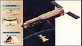
This painting of a KH-9 shows the two different camera types that the satellite carried.
Basic specifications and diagram of the KH-9.
This diagram shows the various sections of the KH-9 and their dimensions.
1 2 3 "The HEXAGON story"(PDF). National Reconnaissance Office (NRO). 1988. Archived from the original(PDF) on 16 September 2012. Retrieved 6 October 2011. This article incorporates text from this source, which is in the public domain.
↑ Doyle, John M., Big Bird, uncaged, Air & Space, December 2011/January 2012, p.10
↑ Richard J. Chester (1985). "A history of the HEXAGON program". National Reconnaissance Office (NRO). Archived from the original on 15 September 2012. Retrieved 24 September 2011. This article incorporates text from this source, which is in the public domain.
↑ K. S. W. Champion; J. M. Forves (1976). "Atmospheric drag analyses of low-altitude Doppler beacon satellites". Satellite Doppler Positioning. 1. New Mexico State University: 343. Bibcode:1976sdp..conf..343C.
↑ Makovics, Jennifer Lavris (April 2024). "Utilising Declassified Cold War Satellite Imagery (KH-9 Hexagon) for Remote Sensing of Historic Hydraulic Management Features in North Africa". 2024 IEEE Mediterranean and Middle-East Geoscience and Remote Sensing Symposium (M2GARSS). pp.391–395. doi:10.1109/M2GARSS57310.2024.10537536. ISBN979-8-3503-5858-2.
This page is based on this Wikipedia article Text is available under the CC BY-SA 4.0 license; additional terms may apply. Images, videos and audio are available under their respective licenses.