
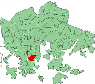
Vuosaari is a neighbourhood in the City of Helsinki, Finland. It is located by the sea in East Helsinki and with its area of 15.38 km2 (5.94 sq mi) is geographically the largest district in the city. It also has two Helsinki Metro stations, Rastila and Vuosaari

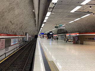
A metro station or subway station is a train station for a rapid transit system, which as a whole is usually called a "metro" or "subway". A station provides a means for passengers to purchase tickets, board trains, and evacuate the system in the case of an emergency. In the United Kingdom, they are known as underground stations, most commonly used in reference to the London Underground.

The Helsinki Metro is a rapid transit system serving the Helsinki capital region, Finland. It is the world's northernmost metro system. It was opened to the general public on 2 August 1982 after 27 years of planning. It is operated by Helsinki City Transport and Metropolitan Area Transport Ltd for Helsinki Regional Transport Authority and carries 92.6 million passengers per year.

Hakaniemi is an unofficial district of Helsinki, the Finnish capital. It covers most of the neighbourhood of Siltasaari in the district of Kallio. Hakaniemi is located at the sea shore and is separated from the city centre by the Siltavuorensalmi strait and from the district of Linjat by the street Hämeentie. Historically, Hakaniemi was often associated with the working class and workers' associations. However, the cost of living has risen considerably in recent years and is now on par with that of the rest of central Helsinki.
Kallio is a district and a neighbourhood in Helsinki, the capital of Finland, located on the eastern side of the Helsinki peninsula about one kilometre north from the city centre. It is one of the most densely populated areas in Finland. Kallio is separated from the city centre by the Siltasaarensalmi strait, over which is a bridge called Pitkäsilta. Traditionally, the bridge symbolizes the divide between the affluent centre and the more working class areas around Kallio.
Kamppi metro station is a station on the Helsinki Metro. In addition to serving the area around Kamppi in central Helsinki, the station is integrated with the Kamppi Center bus terminal and shopping complex. Kamppi is served by both lines M1 and M2.

Sörnäinen metro station is a station on the Helsinki Metro. It serves the central Helsinki districts of Sörnäinen and Kallio. Sörnäinen is the easternmost station on the system to be located underground.

Itäkeskus metro station is a ground-level station on the Helsinki Metro. The station was built on the grounds of the shopping center Itis, and serves the quarter of Itäkeskus in the neighborhood of Vartiokylä in East Helsinki. There are 240 bicycle and 420 car parking spaces at the station. Itäkeskus is served by both M1 and M2 and acts as an exchange station between the two, as it is the easternmost station to be shared by both lines.

Sörnäinen is a neighbourhood in the city of Helsinki, Finland.
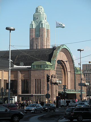
Helsinki Central Station (HEC) is the main station for commuter rail and long-distance trains departing from Helsinki, Finland. About 200,000 people "pass through the station" every day, half of whom are train passengers. The station serves as the terminus for all trains in the Helsinki commuter rail network, as well as for all Helsinki-bound long-distance trains in Finland. The Rautatientori metro station is located in the same building.

Pasila station is a railway station in Helsinki, Finland, approximately 3.5 kilometres (2.2 mi) north of Helsinki Central. It is the second busiest railway station in Finland, after Helsinki Central, and takes up a large part of the district of Pasila. The station was first opened in 1862 along the Finnish Main Line. The current station building opened in 2019.

Pohjois-Haaga railway station is a railway station on the Helsinki commuter rail network located in northern Helsinki, Finland. It is located about eight kilometres to the north/northwest of Helsinki Central railway station.

Majakka is a high-rise building in Kalasatama, Helsinki, Finland. The tower is 134 metres (440 ft) tall, making it the tallest building in Finland. It is divided into 35 floors, and contains 283 residences. The 5th floor has a garden open to the public. The tower is conjoined with the Redi shopping centre and the Kalasatama metro station. The complex will include seven other residential towers, as well as a hotel and offices.

Redi is a shopping centre in Kalasatama, Helsinki, Finland. With its gross leasable area of 64,000 square metres (690,000 sq ft), it is the eighth largest shopping centre in Finland.

Kalasatama is a neighbourhood in the city of Helsinki, Finland. The area is officially part of the Sörnäinen district; and like Sörnäinen, Kalasatama is located a little more than one kilometre north from the coastal centre of Helsinki, near the district of Hakaniemi, and the east side of Kalasatama borders the sea. Itäväylä, which leads in the direction of East Helsinki, runs next to Kalasatama. The Isoisänsilta pedestrian and cycling bridge, opened in 2016, connects Kalasatama to the nearby islands of Mustikkamaa, Korkeasaari and Kulosaari.
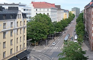
Helsinginkatu is a two-kilometre-long east-west-running street in Helsinki, Finland. The street runs from Hämeentie to Mannerheimintie. The street separates the districts of Kallio and Alppiharju, however the part west to the railway underpass belongs to Taka-Töölö. The eastern part of the street is a 30-metre-wide avenue, with buildings on both sides. Between the avenue part and the railway underpass there are only buildings on the southern side of the street, except for the Helsinki Sports House. To the west of the railway the street runs along the shore of the Töölönlahti bay and the only buildings on it are the Finnish National Opera and Ballet and restaurant Töölönranta. Helsinginkatu is lit with lights hanging from wires and paved with asphalt throughout its length. There is also a tram track running throughout the street.
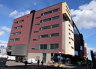
The Kalasatama Health Station is a service centre for health and social services in the Kalasatama neighbourhood of the Sörnäinen district in Helsinki, Finland. It is located about 200 metres to the east-northeast of the Kalasatama metro station.

Sompasaari is an island on the Kruunuvuorenselkä water area in the Sörnäinen district in Helsinki, Finland. On the southern side of the Nihdinkanava channel built in the middle of Sompasaari is the island of Nihti.
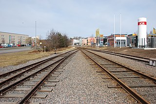
The Sörnäinen harbour rail line was a side rail track in Helsinki, Finland, built in the 1860s, and dismantled in 2009–2010. It was opened in 1863, a year after Finland's first railway line Helsinki–Hämeenlinna. The harbour rail ran from Pasila railway station to Sörnäinen Harbour to serve the port facilities. Originally the line was 3.37 kilometres (2.09 mi) long, running through today's Teollisuuskatu in Vallila, but in 1965 it was re-routed around the inner city area via Pasila Rail Tunnel and Kumpula.

 Metro station escalators to Redi shopping centre
 Ground level entrance to the elevated station
