Glacial plain
The Grand Kankakee Marsh is the result of the last glacial age. The Wisconsin Glacial Episode began 70,000 years ago [2] : 34 and removed all traces of the previous glacial topography. It wasn't until the last 3,000 years that the glaciers left the topography we know today. Beginning around 15,000 years ago, [2] : 35 the Michigan lobe to the north and the Huron-Saginaw lobe to the east retreated back, leaving the area that was to become the Kankakee's valley clear of ice. Beginning 14,000 years ago, the head of the glacier stood along a line across the middle of Lake, Porter, and LaPorte counties. Melting ceased to outpace the arrival of new ice from the north. Over thousands of years, the glacier moved ground rock and soil southward, only to release along this edge of ice, building up a ridge that matched the front of the glacier. [2] : 36 This formed the Valparaiso Moraine.
As soil built up along this front, the spring and summer melt was releasing large volumes of water, which moved and sorted the soils. South of the glacial front, water accumulated faster than it could drain, forming a glacial lake Kankakee. Today, the bedrock is hidden deep beneath the sediments left by the glaciers, but it still played a role in developing the lay of the land. At Momence, Illinois, a ridge of limestone was exposed at the surface. Here, all the water flowing off the front of the glacier had to pass westward, for south of glacial Lake Kankakee, the Iroquois Moraine blocked all drainage. Slight though it might be, it was higher than the limestone ridge. Between the Iroquois Moraine and the Momence Ridge, the waters from the glacier collected.
Lacustrine deposits are those deposited in lake water, and only when the lake drains or the land rises does it become dry land. Most of the soils throughout the counties surrounding the Kankakee are loamy (up to a quarter clay, quarter to half silt, with less than half being sand). [3] The outwash plain is underlain by sand, with gravel inter-bedded throughout. The prevailing westerly winds began to treat the shores of "Lake Kankakee" like the shores of Lake Michigan. Dunes began to form along the southern and eastern shoreline. Where ice blocks had been left behind, sand filled the depressions. Runoff from the Valparaiso Moraine built [2] : 52 outwash ridges of sand leading into the lake. On the south, the winds built dunes.
As the volume of water decreased from the glacier melting northward, the lake slowly drained and filled. Not being able to cut a channel through the limestone ridge in Momence, the Kankakee Lake became 500,000 acres (200,000 ha) of marshland.
The outer margin of the Valparaiso Moraine extends from Porter County east into Michigan. It consists of an extensive outwash apron. It slopes to the southeast over an 8 miles (13 km) to 10 miles (16 km) distance, dropping from 775 feet (236 m) or 800 feet (240 m) to 700 feet (210 m) above sea level. It is a gravel plain, which is dissected by Crooked Creek and Mill Creek. [4]

Prairies are ecosystems considered part of the temperate grasslands, savannas, and shrublands biome by ecologists, based on similar temperate climates, moderate rainfall, and a composition of grasses, herbs, and shrubs, rather than trees, as the dominant vegetation type. Temperate grassland regions include the Pampas of Argentina, Brazil and Uruguay, and the steppe of Ukraine, Russia and Kazakhstan. Lands typically referred to as "prairie" tend to be in North America. The term encompasses the area referred to as the Interior Lowlands of Canada, the United States, and Mexico, which includes all of the Great Plains as well as the wetter, hillier land to the east.

Porter County is a county in the U.S. state of Indiana. As of 2020, the population was 173,215, making it the 10th most populous county in Indiana. The county seat is Valparaiso. The county is part of Northwest Indiana, as well as the Chicago metropolitan area. Porter County is the site of much of the Indiana Dunes, an area of ecological significance. The Hour Glass Museum in Ogden Dunes documents the region's ecological significance.

The Wisconsin Glacial Episode, also called the Wisconsin glaciation, was the most recent glacial period of the North American ice sheet complex, peaking more than 20,000 years ago. This advance included the Cordilleran Ice Sheet, which nucleated in the northern North American Cordillera; the Innuitian ice sheet, which extended across the Canadian Arctic Archipelago; the Greenland ice sheet; and the massive Laurentide Ice Sheet, which covered the high latitudes of central and eastern North America. This advance was synchronous with global glaciation during the last glacial period, including the North American alpine glacier advance, known as the Pinedale glaciation. The Wisconsin glaciation extended from approximately 75,000 to 11,000 years ago, between the Sangamonian Stage and the current interglacial, the Holocene. The maximum ice extent occurred approximately 25,000–21,000 years ago during the last glacial maximum, also known as the Late Wisconsin in North America.

Indiana Dunes National Park is a United States national park located in northwestern Indiana managed by the National Park Service. It was authorized by Congress in 1966 as the Indiana Dunes National Lakeshore and was redesignated as the nation's 61st national park on February 15, 2019. The park runs for about 20 miles (32 km) along the southern shore of Lake Michigan and covers 15,349 acres (6,212 ha). Along the lakefront, the eastern area is roughly the lake shore south to U.S. 12 or U.S. 20 between Michigan City, Indiana, on the east and the Cleveland-Cliffs steel plant on the west. This area's conservation scheme is enhanced by the older Indiana Dunes State Park. To the west of the steel plant lies West Beach and a small extension south of the steel mill continues west along Salt Creek to Indiana 249. The western area is roughly the shoreline south to U.S. 12 between the Burns Ditch west to Broadway in downtown Gary, Indiana. In addition, there are several outlying areas, including Pinhook Bog, in LaPorte County to the east; the Heron Rookery in Porter County, the center of the park; and the Hoosier Prairie State Nature Preserve and the Hobart Prairie Grove, both in Lake County, the western end of the park.

The Kankakee River is a tributary of the Illinois River, approximately 133 miles (214 km) long, in the Central Corn Belt Plains of northwestern Indiana and northeastern Illinois in the United States. At one time, the river drained one of the largest wetlands in North America and furnished a significant portage between the Great Lakes and the Mississippi River. Significantly altered from its original channel, it flows through a primarily rural farming region of reclaimed cropland, south of Lake Michigan.
Northwest Indiana, nicknamed The Region after the Calumet Region, is an unofficial region of northern Indiana, United States that is located at the northwestern corner of the state. Though there is no official definition of the region, it is based on the Gary, Indiana Metropolitan Division, which comprises Jasper, Lake, Porter and Newton counties in Indiana, and the Michigan City-La Porte, IN Metropolitan Statistic Area, which comprises LaPorte, with unofficial definitions also including Starke and Pulaski counties. This region neighbors Lake Michigan and parts of it are in the Chicago metropolitan area. According to the 2020 Census, the largest definition of Northwest Indiana has a population of 866,965 and is the state's second largest urban area after the Indianapolis Metropolitan Area. It is also the home of the Indiana Dunes, parts of which have been preserved through conservation efforts. The town of Ogden Dunes houses the Hour Glass, a museum showcasing the ecological and conservation efforts of O. D. Frank.

Lake Chicago was a prehistoric proglacial lake that is the ancestor of what is now known as Lake Michigan, one of North America's five Great Lakes. Formed about 13,000 years ago and fed by retreating glaciers, it drained south through the Chicago Outlet River.
The geology of Illinois includes extensive deposits of marine sedimentary rocks from the Palaeozoic, as well as relatively minor contributions from the Mesozoic and Cenozoic. Ice age glaciation left a wealth of glacial topographic features throughout the state.

The geography of Indiana comprises the physical features of the land and relative location of U.S. State of Indiana. Indiana is in the north-central United States and borders on Lake Michigan. Surrounding states are Michigan to the north and northeast, Illinois to the west, Kentucky to the south, and Ohio to the east. The entire southern boundary is the Ohio River.
The Iroquois County State Wildlife Area is an Illinois state park that occupies 2,480 acres (1,004 ha) in northeastern Iroquois County, near the border with Indiana. The nearest municipality is Beaverville, Illinois, and the nearest exit on a limited-access highway is Exit 302 on Interstate 57.

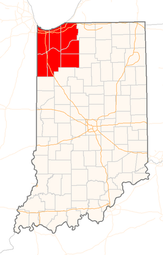
The Valparaiso Moraine is a recessional moraine that forms an immense U around the southern Lake Michigan basin in North America. It is a band of hilly terrain composed of glacial till and sand. The Valparaiso Moraine defines part of the continental divide known as the Saint Lawrence River Divide, bounding the Great Lakes Basin. It begins near the border of Wisconsin and Illinois and extends south through Lake, McHenry, Cook, DuPage and Will counties in Illinois, and then turns southeast, going through northwestern Indiana. From this point, the moraine curves northeast through Lake, Porter, and LaPorte counties of Indiana into Michigan. It continues into Michigan as far as Montcalm County.
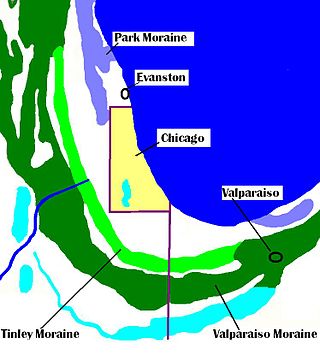
The Tinley Moraine is a moraine around the Lake Michigan basin in North America. It was formed during the Wisconsin Glaciation and is younger than the higher and wider terminal moraine called the Valparaiso Moraine, which is located farther from the lake than the Tinley Moraine. Compared to the Valparaiso Moraine, the Tinley Moraine is much narrower and occupies a similar swath, about 6 miles (10 km) closer to Lake Michigan, and passes through the communities of Flossmoor, Western Springs, and Arlington Heights. The moraine was named after the village of Tinley Park, a village southwest of Chicago that lies on the moraine.

The Calumet Shoreline is an ancient shoreline of Lake Michigan located in the Lake Michigan Basin. It can be clearly seen as a sand ridge along Ridge Road south of Chicago. Closer to the lake from the Calumet Shoreline, there are the Tolleston shorelines and farther from the lake are the Glenwood Shoreline, the Tinley Moraine, and the Valparaiso Moraine. The shoreline is named after the Calumet Region of Northern Indiana.

The Glenwood Shoreline is an ancient shoreline of the precursor to Lake Michigan, Lake Chicago. It is named after the town of Glenwood, Illinois. The shoreline was formed when the lake was higher during the last ice age, while ice blocked the Straits of Mackinac. After the straits were freed, the lake receded and left behind a sand ridge at an elevation of about 640 feet (200 m) where the shore resided. This ridge can be seen clearly in Glenwood, Illinois, Dyer, Indiana, and Schererville, Indiana, all south of Chicago.
The Indiana Dunes are natural sand dunes occurring at the southern end of Lake Michigan in the American State of Indiana. They are known for their ecological significance. Many conservationists have played a role in preserving parts of the Indiana Dunes. The Hour Glass, a museum in Ogden Dunes, showcases some of the ecological import of the Dunes.

The Kankakee Torrent was a catastrophic flood that occurred about 19,000 calibrated years ago in the Midwestern United States. It resulted from a breach of moraines forming a large glacial lake fed by the melting of the Late Wisconsin Laurentide Ice Sheet. The point of origin of the flood was Lake Chicago. The landscape south of Chicago still shows the effects of the torrent, particularly at Kankakee River State Park and on the Illinois River at Starved Rock State Park.
The Toleston Shoreline is the third ancient shoreline of the precursor to Lake Michigan, Lake Chicago. It takes its name from the village of Tolleston, now a portion of Gary, Indiana. The shoreline formed when Lake Chicago was high enough to drain through the Chicago outlet into the Des Plaines River. The beach is 18 to 25 feet above the level of Lake Michigan. The Indiana segment and the Illinois segment, north to Evanston are still visible. North of Evanston and Michigan City, Indiana, the beach has been eroded by later ice movement or shoreline wave action.

Lake Kankakee formed 14,000 years before present (YBP) in the valley of the Kankakee River. It developed from the outwash of the Michigan Lobe, Saginaw Lobe, and the Huron-Erie Lobe of the Wisconsin glaciation. These three ice sheets formed a basin across Northwestern Indiana. It was a time when the glaciers were receding, but had stopped for a thousand years in these locations. The lake drained about 13,000 YBP, until reaching the level of the Momence Ledge. The outcropping of limestone created an artificial base level, holding water throughout the upper basin, creating the Grand Kankakee Marsh.

The Marseilles moraine is a terminal moraine that encircles the southern tip of Lake Michigan in North America. It begins near Elgin, Illinois, and extends south and west of Chicago metropolitan area, turning eastward 30 miles (48 km) to 40 miles (64 km) south of the lake in Kankakee and Iroqouis counties, entering Indiana. It formed during the Wisconsin glaciation. The glacier had been in retreat when it stopped for an extended period, depositing glacial till and sand creating the hills of the moraine.
The Collier Lodge site, located in Porter County, Indiana, is one of the few places the Kankakee Marsh could be easily crossed. The site has been occupied for over 11,000 years with evidence of human occupation from 1,000 B.C.E. Historic records of humans occupation in northwestern Indiana are available from the late seventeenth century. The prehistoric and historic cultural deposits are unique for northwestern Indiana. Prehistoric artifacts from the site represent most time periods over the last nine to ten thousand years and historic artifacts span the full range of historic occupations in northwestern Indiana. Prehistoric archaeological features documented at the site include two different types of roasting pits and small features whose functions are unknown. Historic features include the remains of a fireplace, post molds, and what is now thought to be a cellar marks the location of a previously undocumented structure. Concentrations of animal bones from the early nineteenth century indicate furs were processed at the site.
