Karaburun Peninsula, Albania

Last updated
Gadishulli Peninsula
Albanian: Gadishulli i Karaburunit
June 22 2013 432 HSV Albanische Riviera.jpg
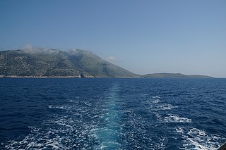
Satellite imagery of Karaburun Peninsula
Karaburun Peninsula, Albania
Geography
Location
Coordinates 40°20′N19°22′E / 40.333°N 19.367°E / 40.333; 19.367
Adjacent to
Adriatic Sea (north)
Ionian Sea (south)
Area62 km2 (24 sq mi)
Highest pointMaja Çaderës (839 mAA)

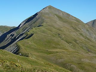
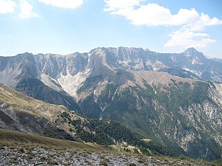
The Gadishulli Peninsula (Albanian : Gadishulli i Karaburunit), also known as Cape Linguetta, is a peninsula of the Mediterranean Sea located in Southern and Southeastern Europe, which is almost completely surrounded by both the Adriatic Sea to the north and the Ionian Sea to the south. It is located in Southwestern Albania along the Albanian Ionian Sea Coast, whereas the Strait of Otranto separates it from Italy. The Strait of Mezokanal separates the peninsula from Sazan Island, while in the southeast stretches the Bay of Vlorë. In classical antiquity, its name was the "Akrokeraunian Peninsula" (Ακροκεραύνιο ακρωτήριο), whose name was derived from the eponymous Akrokeraunian mountains;this is because, in terms of geology, the Rrëza e Kanalit on the peninsula represent the continuation of said mountains, which are the highest and most extensive mountain range system that extends parallel to the Ionian Sea. [1] Karaburun peninsula is sometimes called Ceraunian Peninsula due to the name of the mountain range. [2] [3] Created during the mesozoic era of the cretaceous and paleogene period, the crests of the mountain range form a northwest-southeast line with a series of distinct peaks along its irregular structure that are broken apart by steep and unequally slopes. [4] The highest peaks are namely, the Maja Çaderës, Maja e Flamurit, Maja e Koretës and Maja e Ilqes.

Contents

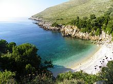
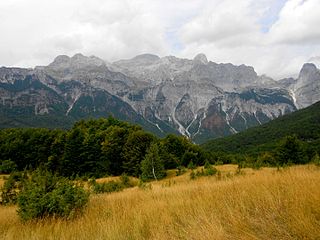
The western section comprises a rough relief and is dotted with sandy and rocky beaches, sea caves, steep cliffs and several bays amongst them Cave of Haxhi Ali, Cape of Gjuhëz, Bay of Skaloma, Bay of Arushë, Bay of Dafinë, and most notably Bay of Grama, where ships and vessels anchored during classical antiquity. On the high and steep rock faces of the bay, which served also as a marble quarry, there are hundreds of rock inscriptions dating back to the 4th century BC. [5] [6] [7] [8] [9]

Under the Köppen climate classification, the peninsula experiences a mediterranean climate with hot summers and generally warm to cool, dry winters. The ideal climate and contrasting landscapes located at the sea have favored the development of a vast array of habitats which in turn are home to a diverse wildlife. The fauna is represented by several threatened and endangered species such as the loggerhead and green sea turtle but also the mediterranean monk seal, the rarest seal species in the world. [10] [11] [12]

The landmass of the peninsula is designated as nature reserve, while the shoreline and its surrounding sea waters are part of the marine park. [13] [14] [15] [16] In 2014, the Regina Blu ferry was established by a Radhime-based hotel owner making trips between the peninsula and the island of Sazan, while stopping along the secluded beaches. [17]

The peninsula belongs to the Sazan Zone that is a constituent of the Albanides tectonic unit. Albanides form the link between Dinarides and Hellenides orogenic belts. They are considered allocthonous and mobilist theories deduce they come from the east. [18] These formations have been continuously under the effect of Karst and are exploited as marble (metamorphosed limestone) since antiquity. [19] The widespread Karst topography is responsible for the absence of potable water and thus the absence of any population on the peninsula. Despite the dry surface and upper soil layers, there are several water sources that pour deep directly into the sea. The geological evolution has formed also capes such as Galloveci cape and Kepi i Gjuhëzës, as well as a total number of 20 caves along the whole coast. [20]

See also

Related Research Articles

<span class="mw-page-title-main">Geography of Albania</span>

Albania is a country in Southeastern Europe that lies along the Adriatic and Ionian Seas, with a coastline spanning approximately 476 km (296 mi). Situated on the Balkan Peninsula, it is one of the most mountainous countries in Europe. It is bounded by Montenegro to the northwest, Kosovo to the northeast, North Macedonia to the east and Greece to the southeast and south.

<span class="mw-page-title-main">Gramos</span> Mountain on the Albanian-Greek border

Gramos is a mountain chain situated on the border of Albania and Greece. Part of the larger northern Pindus mountain range, its highest peak, Maja e Çukapeçit, rises at an elevation of 2,523 m (8,278 ft).

<span class="mw-page-title-main">Shkëlzen</span> Mountain in Albania

Shkëlzen is a mountain situated in the Albanian Alps, bounded by the Tropojë river valley to the northeast, the Gashi river valley to the southwest, and the Tropojë basin to the southeast. It is the higher of the two peaks, Maja e Shkëlzenit, reaching a height of 2,405 m (7,890 ft).

Veleçik is a mountain located in the Albanian Alps, within the boundaries of Malësia e Madhe municipality, reaching a height of 1,727 m (5,666 ft).

<span class="mw-page-title-main">Maja e Papingut</span> Mountain in Albania

Maja e Papingut is a mountain peak of the Nemërçka massif, in southern Albania. Reaching a height of 2,482 m (8,143 ft), it is the 3rd most prominent peak in the country and the 44th most prominent peak in Europe.

<span class="mw-page-title-main">Dejë (mountain)</span> Mountain in Albania

Dejë is a mountain located in the municipality of Mat, in northeastern Albania. Elevating at a height of 2,244 m (7,362 ft), it is bounded by the Burrel basin in the west and Maja e Runjës in the east. Qafëmurrë in the southeast separates it from Mali i Balgjajt, while the valley of Zall Gjoçaj, the left branch of the Uraka river in the north, separates it from the karst plateau of Valmura.

Çuka Partizani is the highest peak of the Tomorr massif, located in south-central Albania. Part of the larger Tomorr-Kulmak-Miçan mountain range, it reaches a height of 2,416 m (7,927 ft), making it the second highest peak in the Southern Mountain Region after Maja e Papingut.

<span class="mw-page-title-main">Stillo Islet</span> Island in Albania

Stillo Islet or Stil Islet is a small islet located in Xarrë, southern Albania, on the Ionian Sea.

<span class="mw-page-title-main">Ceraunian Mountains</span> Mountain range in Albania

The Ceraunian Mountains are a coastal mountain range in southwestern Albania, within the Vlorë County.

<span class="mw-page-title-main">Llogara National Park</span> National park and a tourist attraction in Albania

Llogara National Park is a national park centered on the Ceraunian Mountains along the Albanian Riviera in Southwestern Albania, spanning a surface area of 1,769 ha (17.69 km2). The park's terrain includes large alpine meadows, vertical rock faces, precipices and dense forests. The most area of land is covered by forests and was established in 1966 to protect several ecosystems and biodiversity of national importance. The International Union for Conservation of Nature (IUCN) has listed the park as Category II. The region has been recognised as an important Bird and Plant Area, because it support significant numbers of various bird and plant species.

<span class="mw-page-title-main">Cape of Gjuhëz</span> Cape in Albania

The Cape of Gjuhëz is a rocky cape northwest of Karaburun Peninsula as well as the westernmost point of continental Albania. It projects 1.1 kilometres (0.68 mi) into the sea in the form of the tongue, thus the origin of its name. The altitudes of the cape slope gradually towards the water, whereas the southern shores form 30 to 40 metres high steep cliffs that fall directly to the Ionian sea. The cape lacks vegetation, while limestone rocks, highly eroded by Karst are spread over whole the area.

Bureto is a mountain located in the municipality of Libohovë, in southern Albania. It forms an integral part of the Shëndelli-Lunxhëri-Bureto mountain range. Its highest peak, Maja e Arkovolës, reaches a height of 1,763 m (5,784 ft).

<span class="mw-page-title-main">Karaburun-Sazan Marine Park</span> Protected area and a tourist attraction in Albania

Karaburun-Sazan Marine Park is a marine park in the Vlorë County of southwestern Albania. The marine park encompasses over 125.70 km2 (48.53 sq mi) and comprises the boundaries of both the Peninsula of Karaburun and the Island of Sazan. It is home to a vast array of landforms, including mountains, caves, islands, depressions, bays, cliffs, canyons and rocky coasts, all contributing to an exceptionally considerable biological diversity. The marine park has been identified as an Important Bird and Plant Area, because it supports immense bird and plant species. Containing ecosystems and habitats that are specific to the Mediterranean Basin, the convention of Barcelona has classified the marine park as a Specially Protected Areas of Mediterranean Importance.

<span class="mw-page-title-main">Griba</span> Mountain in Albania

Griba is a massif situated in the Upper Kurvelesh region, within the boundaries of Tepelenë municipality, in southern Albania. Its highest peak, Maja e Këndrevicës, reaches a height of 2,122 m (6,962 ft).

<span class="mw-page-title-main">Radohina</span> Mountain in Albania

Radohina is a massif situated in the Albanian Alps, within the boundaries of Shkodër municipality. Its main peak, Maja e Radohinës, reaches a height of 2,568 m (8,425 ft).

<span class="mw-page-title-main">Cave of Haxhi Ali</span> Cave in southern Albania

The Cave of Haxhi Ali is a karst cave formed in limestone cliffs in southwestern Albania, located in the Karaburun Peninsula near the Cape of Gjuhëz in Vlorë County. The cave was named after Haxhi Aliu, a prominent Albanian warrior and sailor from Ulcinj who fled with his son in this cave. Several archaeological objects has been found, that prove that this cave was used by traders and passers during the ancient times. The cave has a length of 30 m (98 ft) with a width which can vary between of 10–12 m (33–39 ft) and a height of 18 m (59 ft).

<span class="mw-page-title-main">Bay of Grama</span> Bay in the Ionian sea and a tourist attraction in Albania

The Bay of Grama is a bay in the Ionian Sea situated along the Albanian Ionian Sea Coast on the Mediterranean Sea in Southern Europe. It is one of many bays of the western Ceraunian Mountains along the Albanian Riviera south of the Karaburun Peninsula. The bay is primarily known as a touristic place, and for the engraved inscriptions in the surrounding coastal cliffs as its name relieves.

Mali i Shpatit is a massif located in the southeastern part of Elbasan municipality, near the border with Librazhd, in central Albania. It has a northwest–southeast orientation, spanning a length of approximately 20 km (12 mi) and a width of 4–5 km (2.5–3.1 mi). Its highest peak, Maja e Bukanikut, reaches a height of 1,823 m (5,981 ft).

<span class="mw-page-title-main">Rrëza e Kanalit</span> Mountain in Albania

Rrëza e Kanalit is a mountain located on the Ionian Coast of Albania, within the boundaries of Vlorë municipality. It stretches between the Karaburun Peninsula in the northwest and Llogara Pass in the southeast, at a length of 23 km (14 mi) and a width of 3–7 km (1.9–4.3 mi). Its highest peak, Shën Iliu, reaches a height of 1,499 m (4,918 ft).

References

  1. "Management Plan Llogora-Rreza e Kanalit-Dukat -Orikum-TragjasRadhime-Karaburun Complex Site" (PDF). vinc.s.free.fr (in Albanian).
  2. Richard Stillwell, The Princeton Encyclopedia of Classical Sites, 2007, p.655
  3. Cynthia Damon, Studies on the Text of Caesar's Bellum civile, OUP Oxford, ISBN   9780191035944, 2015, p. 211
  4. E.M. Moores, Rhodes W. Fairbridge (30 November 1997). Encyclopedia of European and Asian Regional Geology. Springer Science & Business Media, 1997. ISBN   9780412740404.
  5. "THE FIRST MPA IN ALBANIA, SAZANI ISLAND – KARABURUNI PENINSULA, AS A REGIONAL PRIORITY CONSERVATION AREA FOR MARINE BIODIVERSITY" (PDF). zrsvn.si. Archived from the original (PDF) on 2014-08-19. Retrieved 2018-07-07.
  6. Peter Lucas (16 February 2015). The OSS in World War II Albania: Covert Operations and Collaboration with Communist Partisans. McFarland, 2017. p. 50. ISBN   9781476609430.
  7. "Gadishulli i Karaburunit". Archived from the original on 2010-11-01. Retrieved 2010-10-30.
  8. [Fjalori Enciklopedik Shqiptar, Akademia e Shkencave - Tiranē, 1984 (GRAMATA, page 317)]
  9. Gramata [ permanent dead link ]
  10. World Wide Fund for Nature. "Mediterranean Monk Seal One Of The Rarest Mammals In The World". wwf.panda.org/.
  11. Lonely Planet (2009). Western Balkans. Lonely Planet, 2009. p. 60. ISBN   9781741047295.
  12. [Fjalori Enciklopedik Shqiptar, Akademia e Shkencave - Tiranē, 1984 (KARABURUNI, page 455)]
  13. Ministria e Mjedisit e Shqipërisë. "RRJETI I ZONAVE TË MBROJTURA NË SHQIPËRI" (PDF). cbd.int (in Albanian). Tirana. pp. 1–3.
  14. "Management Plan Llogora-Rreza e Kanalit-Dukat -Orikum-TragjasRadhime-Karaburun Complex Site" (PDF). vinc.s.free.fr. p. 28.
  15. Proclamation of Karaburun-Sazan as National Marine Park, April 2010
  16. "Management Plan for National Marine Park Karaburun-Sazan" (PDF). mcpa.iwlearn.org. p. 10. National Park of the marine natural ecosystem has been proclaimed on 28 April 2010
  17. "Services - Hotel Regina, Radhime, Vlore".
  18. [Nopcsa, 1929; Nowak 1929]
  19. [Fjalori Enciklopedik Shqiptar, Akademia e Shkencave - Tiranē, 1984 (page 455)]
  20. "Gadishulli i Karaburunit : Portali Shqip". Archived from the original on 2010-11-01. Retrieved 2010-10-30.