
A megatsunami is a very large wave created by a large, sudden displacement of material into a body of water.

A seiche is a standing wave in an enclosed or partially enclosed body of water. Seiches and seiche-related phenomena have been observed on lakes, reservoirs, swimming pools, bays, harbors, caves, and seas. The key requirement for formation of a seiche is that the body of water be at least partially bounded, allowing the formation of the standing wave.

Disko Island is a large island in Baffin Bay, off the west coast of Greenland. It has an area of 8,578 km2 (3,312 sq mi), making it the second largest of Greenland after the main island and one of the 100 largest islands in the world.
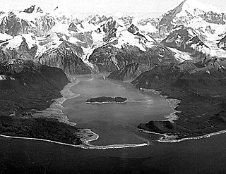
Lituya Bay is a fjord located on the coast of the south-east part of the U.S. state of Alaska. It is 14.5 km (9 mi) long and 3.2 km (2 mi) wide at its widest point. The bay was noted in 1786 by Jean-François de Lapérouse, who named it Port des Français. Twenty-one of his men perished in the tidal current in the bay.
Saqqaq is a settlement in the Avannaata municipality in western Greenland. Founded in 1755 as Solsiden, Saqqaq had 132 inhabitants in 2020. The village's Kalaallisut name is a translation of the Danish meaning "Sunny Side", in reference to its position relative to Livets Top.
Illorsuit is a former settlement in Avannaata municipality, in western Greenland. Located on the northeastern shore of Illorsuit Island − northwest of Uummannaq at the mouth of the Uummannaq Fjord − the settlement had 91 inhabitants in 2010. It was abandoned in 2018.

Nuugaatsiaq is a settlement in the Avannaata municipality, in northwestern Greenland, located on an island off the southern coast of Sigguup Nunaa peninsula, in the Uummannaq Fjord basin. It had 84 inhabitants in 2010, but was abandoned after a tsunami struck in 2017.

Lovatnet is a lake in the municipality of Stryn in Vestland county, Norway. It is located about 2 kilometres (1.2 mi) southeast of the village of Loen and about 6 kilometres (3.7 mi) east of the village of Olden. The lake lies just 2 kilometres (1.2 mi) southwest of the mountain Skåla. The water from the lake flows down from the mountains; especially from the Jostedalsbreen and Tindefjellbreen glaciers. It then flows out through the Loelva river into the Nordfjorden.

Icy Bay is a body of water in the borough of Yakutat, Alaska, formed in the last 100 years by the rapid retreat of the Guyot, Yahtse, and Tyndall Glaciers. It is part of the Wrangell-Saint Elias Wilderness.

Alluttoq Island is a large 655 km2 (252.9 sq mi), uninhabited island in Avannaata municipality in western Greenland, located in the northern part of Disko Bay, in the outlet of the Sullorsuaq Strait, east of Disko Island.

Ella Island is an island in eastern Greenland, within Northeast Greenland National Park. It was established in 1941 to enforce Danish sovereignty in Greenland.. It is home of the legendary Sirius Dog Sled Patrol.

Nuussuaq Peninsula is a large peninsula in western Greenland.

The 1958 Lituya Bay earthquake occurred on PST with a moment magnitude of 7.8 to 8.3 and a maximum Mercalli intensity of XI (Extreme). The strike-slip earthquake took place on the Fairweather Fault and triggered a rockslide of 30 million cubic meters and about 90 million tons into the narrow inlet of Lituya Bay, Alaska. The impact was heard 80 kilometers (50 mi) away, and the sudden displacement of water resulted in a megatsunami that washed out trees to a maximum elevation of 524 meters at the entrance of Gilbert Inlet. This is the largest and most significant megatsunami in modern times; it forced a re-evaluation of large-wave events and the recognition of impact events, rockfalls, and landslides as causes of very large waves.
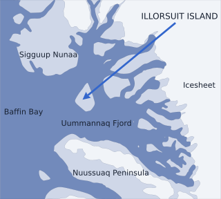
Nunavik Peninsula is a large peninsula in northwestern Greenland. It separates two cultural and geographical regions of northwestern Greenland: Uummannaq Fjord region in the southeast, and Upernavik Archipelago in the north.

Qullissat is a former settlement in the Qeqertalik municipality, located on the northeast coast of Disko Island on the west coast of Greenland. It was a coal mining town founded to exploit the natural resources of Disko Island. The mines operated for 48 years until 1972, when the economic base of the settlement collapsed, leading to its abandonment.
Sullorsuaq Strait is a strait on the western coast of Greenland.
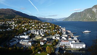
Stranda is the administrative centre of Stranda Municipality in Møre og Romsdal county, Norway. The village is located on the western shore of the Storfjorden. The 2.4-square-kilometre (590-acre) village has a population (2018) of 2,969 and a population density of 1,237 inhabitants per square kilometre (3,200/sq mi). This is the largest urban area in the municipality.
Qeqertarsuaq is an island in Avannaata municipality, located in the Karrat Fjord in northwestern Greenland. Nearby islands are Illorsuit Island and Upernivik Island.
On September 16, 2023, a massive landslide occurred in Dickson Fjord, northeastern Greenland. It was triggered by a series of factors, including the glacial debuttressing due to climate change. Greenland, being highly sensitive to rising temperatures, has experienced accelerated glacial retreat and destabilization in recent years, making landslides more frequent and severe.
