Kerki

Last updated
Kerki
Atamyrat (1999-2017)
Zamm (in antiquity)
Kerki airport.jpg
Kerki airport
Turkmenistan adm location map.svg
Red pog.svg
Kerki
Location in Turkmenistan
Coordinates: 37°51′11″N65°14′13″E / 37.85306°N 65.23694°E / 37.85306; 65.23694
Country Flag of Turkmenistan.svg Turkmenistan
Province Lebap Province
District Kerki District
Population
 (2011)
  Total96,720
Time zone UTC+5

Kerki is a city in and capital of Kerki District, Lebap Province, Turkmenistan. It was formerly known as Zamm [1] and, between 1999 and 2017, as Atamyrat.

Contents

Geography

It is situated on a plain on the left bank of the Amu Darya river. Nearby towns and villages include Mukry (3.3 nm), Amydarýa (2.1 nm), Surhy (3.1 nm) and Kerkichi (2.2 nm). [2]

Climate

Climate data for Kerki (1991–2020)
MonthJanFebMarAprMayJunJulAugSepOctNovDecYear
Record high °C (°F)24.4
(75.9)
29.9
(85.8)
35.4
(95.7)
39.0
(102.2)
42.8
(109.0)
44.4
(111.9)
46.0
(114.8)
45.5
(113.9)
41.1
(106.0)
36.7
(98.1)
32.9
(91.2)
27.4
(81.3)
46.0
(114.8)
Mean maximum °C (°F)19.5
(67.1)
23.0
(73.4)
29.5
(85.1)
34.9
(94.8)
39.1
(102.4)
42.2
(108.0)
43.7
(110.7)
42.1
(107.8)
38.5
(101.3)
32.7
(90.9)
27.7
(81.9)
21.1
(70.0)
32.8
(91.0)
Daily mean °C (°F)4.7
(40.5)
7.1
(44.8)
12.7
(54.9)
19.1
(66.4)
25.1
(77.2)
29.7
(85.5)
31.0
(87.8)
28.8
(83.8)
23.2
(73.8)
16.6
(61.9)
10.2
(50.4)
5.6
(42.1)
17.8
(64.0)
Mean minimum °C (°F)−6.8
(19.8)
−5.8
(21.6)
−0.9
(30.4)
4.7
(40.5)
11.2
(52.2)
16.3
(61.3)
18.0
(64.4)
14.7
(58.5)
8.9
(48.0)
2.3
(36.1)
−2.9
(26.8)
−6.1
(21.0)
4.5
(40.1)
Record low °C (°F)−22.8
(−9.0)
−19.0
(−2.2)
−6.9
(19.6)
−0.3
(31.5)
6.2
(43.2)
12.6
(54.7)
16.4
(61.5)
11.2
(52.2)
4.8
(40.6)
−3.6
(25.5)
−9.0
(15.8)
−20.9
(−5.6)
−22.8
(−9.0)
Average precipitation mm (inches)25.7
(1.01)
36.9
(1.45)
37.0
(1.46)
28.2
(1.11)
10.0
(0.39)
1.7
(0.07)
0.9
(0.04)
0.0
(0.0)
0.2
(0.01)
3.5
(0.14)
17.6
(0.69)
23.3
(0.92)
185.0
(7.28)
Average precipitation days (≥ 1.0 mm)16.118.417.513.96.71.10.30.00.42.412.012.2100.9
Source: NOAA [3]

Etymology

According to Atanyyazow, the name Kerki is most likely of Persian origin, from ker ("fortress") and kuh ("mountain"), meaning "fortress on a mountain". [4] However, Muqaddasī and de Goeje assert it is a Turkified pronunciation of the Persian name Karkuh (کرکوه), meaning "deaf mountain". [5] The ancient name, Zamm, is of obscure origin.

On 29 December 1999, by Parliamentary Resolution HM-60, the city and district of Kerki were renamed Atamyrat in honor of Atamyrat Nyýazow, father of Saparmurat Niyazov, who had worked in Kerki as a teacher before being killed in World War II. On 25 November 2017, by Parliamentary Resolution No. 679-V, Atamyrat was changed back to Kerki for both the city and the district. [6]

Architecture

The urban core consists of numerous one-story brick structures dating back to the period of the Russian Empire.. [7]

Transportation

Air

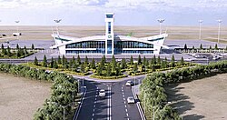
The town is served by the new Kerki Airport, which replaced a defunct municipal airport in 2021. [8]

Road

Kerki lies on the P-36 and P-39 highways, which both lead northwest to Turkmenabat, one on each side of the Amu Darya. Nearby junctions connect to the P-89, which leads north to the border with Uzbekistan at Tallymerjen, and the P-37, which leads southeast to the border with Uzbekistan at Kelif. In the opposite direction the P-36 also continues south to a junction with the Kerki-Ymamnazar ýoly, which in turn leads to the border with Afghanistan at Ymamnazar. [9] In February 2013, a road bridge connecting the city with Kerkichi was commissioned; [10] it replaced an old pontoon bridge. [7]

Rail

In 1999, the rail line from Türkmenabat to Kerki was finished, linking Kerki to the Turkmen railway network without having to detour into neighbouring Uzbekistan. [11] In late 2016, a railway line was built south to Ymamnazar on the border with Afghanistan and further to Aqina, turning Kerki into a railway hub. [12]

Sights

Astana Baba Mausoleum is managed by the Kerki city museum, and consists of a minaret and tomb built in the 11th century. Allamberdar Mausoleum (ru) is also part of the Kerki city museum. This 11th-century building represents Seljuk architecture of northern Khorasan.

See also

Related Research Articles

<span class="mw-page-title-main">Amu Darya</span> River in Central Asia

The Amu Darya, also called the Amu, the Amo, and historically the Oxus, is a major river in Central Asia and Afghanistan. Rising in the Pamir Mountains, north of the Hindu Kush, the Amu Darya is formed by the confluence of the Vakhsh and Panj rivers, in the Tigrovaya Balka Nature Reserve on the border between Afghanistan and Tajikistan, and flows from there north-westwards into the southern remnants of the Aral Sea. In its upper course, the river forms part of Afghanistan's northern border with Tajikistan, Uzbekistan, and Turkmenistan. In ancient history, the river was regarded as the boundary of Greater Iran with Turan, which roughly corresponded to present-day Central Asia. The Amu Darya has a flow of about 70 cubic kilometres per year on average.

<span class="mw-page-title-main">Geography of Turkmenistan</span> Overview of the geography of Turkmenistan

Turkmenistan is a landlocked country in Central Asia, bordering the Caspian Sea to the west, Iran and Afghanistan to the south, Uzbekistan to the north-east, and Kazakhstan to the north-west. It is the southernmost republic of the Commonwealth of Independent States (CIS), the loose federation created at the end of 1991 by most of the Post-Soviet states.

Transport in Turkmenistan includes roadways, railways, airways, seaways, and waterways, as well as oil-, gas-, and water pipelines. Road-, rail-, and waterway transport fall under the jurisdiction of the Ministry of Industry and Communications.

<span class="mw-page-title-main">Lebap Region</span> Region of Turkmenistan

Lebap Region is one of the regions of Turkmenistan. It is in the northeast of the country, bordering Afghanistan, Uzbekistan along the Amu Darya. Its administrative centre is Türkmenabat. It has an area of 93,727 square kilometers, and a population of 1,447,298 people.

<span class="mw-page-title-main">Türkmenabat</span> Capital of Lebap Province, Turkmenistan

Türkmenabat, formerly Amul, Çärjew, and Novy Chardzhuy, is the second-largest city in Turkmenistan and the administrative centre of Lebap Province. As of 2009, it had a population of approximately 254,000 people. From 1924 to 1927, it was also named Leninsk in honor of Vladimir Lenin.

<span class="mw-page-title-main">Konye-Urgench</span> City in north Turkmenistan on the site of the former capital of Khwarazm

Konye-Urgench, also known as Old Urgench or Urganj, is a city of about 30,000 inhabitants in north Turkmenistan, just south from its border with Uzbekistan. It is the site of the ancient town of Gurgānj, which contains the ruins of the capital of Khwarazm. Its inhabitants deserted the town in the early eighteenth century in order to develop a new settlement, and Konye-Urgench has remained undisturbed ever since. In 2005, the ruins of Old Urgench were inscribed on the UNESCO List of World Heritage Sites.

<span class="mw-page-title-main">Emirate of Bukhara</span> 1785–1920 state in Central Asia

The Emirate of Bukhara was a Muslim polity in Central Asia that existed from 1785 to 1920 in what is now Uzbekistan, Tajikistan, Turkmenistan and Kazakhstan. It occupied the land between the Amu Darya and Syr Darya rivers, known formerly as Transoxiana. Its core territory was the fertile land along the lower Zarafshon river, and its urban centres were the ancient cities of Samarqand and the emirate's capital, Bukhara. It was contemporaneous with the Khanate of Khiva to the west, in Khwarazm, and the Khanate of Kokand to the east, in Fergana. In 1920, it ceased to exist with the establishment of the Bukharan People's Soviet Republic.

Çagagüzer is the former name of a village in eastern Turkmenistan near the border with Afghanistan. It is located in Burguçy geňeşligi, Kerki District, Lebap Province.

Darganata is the capital city of Darganata District in Lebap Province of Turkmenistan.

<span class="mw-page-title-main">Garabekewül</span> Place in Lebap Province, Turkmenistan

Garabekewül is a city in Saýat District, Lebap Province, Turkmenistan.

Köýtendag is a city and the administrative center of Köýtendag District in Lebap Province, Turkmenistan. On 29 December 1999, by Parliamentary Resolution No. HM-61, the city and district of Çarşangy were renamed Köýtendag. On 27 July 2016, by Parliamentary Resolution No. 425-V the town of Köýtendag was upgraded in status to "city in a district".

<span class="mw-page-title-main">Index of Turkmenistan-related articles</span>

The list of Turkmenistan-related articles is below

Amu Dar'ya is a town in Köýtendag District, Lebap Province, Turkmenistan, on the river of the same name opposite the town of Kerki. As of 1989, it had a population of 5,018.

<span class="mw-page-title-main">Rail transport in Turkmenistan</span> Overview of rail transport in Turkmenistan

Turkmenistan has 4,980 kilometres (3,090 mi) of railways. The railway operator is the state owned company Türkmendemirýollary. The company belongs to the Ministry of Railways of Turkmenistan. Turkmenistan is currently expanding its rail system to cover 5,256.25 kilometres (3,266.08 mi) more distance, which will take its network to 10,236.25 kilometres (6,360.51 mi) track kilometres by 2025.

Turkmenistan is a country with large potential for an expanded tourism industry. Many of its Central Asian cities were main points of trade on the Silk Road, linking Eastern and Western civilizations. Many neighboring countries promote their countries based on their location along the Great Silk Road. Tourism has grown rapidly in recent years. Tourists from abroad are deterred by the restrictive visa policy regime with all countries of the world. Tourism is regulated by the Tourism Committee of Turkmenistan.

Open joint-stock company Deryayollary is a state-owned operator of waterways and river-ports in Turkmenistan. The company operates 1,013 km (629 mi) of river-ways on Amu Darya and Karakum Canal. The company belongs to the Turkmendenizderyayollary Agency. Operator based in Turkmenabat.

<span class="mw-page-title-main">Railways Agency of Turkmenistan</span> Turkmen government agency

The Railways Agency of Turkmenistan (Turkmen: "Türkmendemirýollary" agentligi, previously the Ministry of Railways, is a government agency in Turkmenistan responsible for oversight of the state rail corporation "Demirýollary" AGPJ.

Mukry is a town in Köýtendag District, Lebap Province, Turkmenistan. It is located near Kerki and Amu Dar'ya.

<span class="mw-page-title-main">Turkmenistan–Uzbekistan border</span> International border

The Turkmenistan–Uzbekistan border is the border between the countries of Turkmenistan and the Republic of Uzbekistan. At 1,793 km, it is Turkmenistan's longest border and Uzbekistan's second longest. The border runs from the tripoint with Kazakhstan to the tripoint with Afghanistan.

References

  1. Bosworth, C. E. (1989). "ĀMOL (ĀMŪYA)". Archived copy. Encyclopaedia Iranica, Vol. I, Fasc. 9. pp. 982–983. Archived from the original on 2017-12-29. Retrieved 2016-02-08.{{cite encyclopedia}}: CS1 maint: archived copy as title (link)
  2. Falling rain gazetteer
  3. "World Meteorological Organization Climate Normals for 1991-2020". National Oceanic and Atmospheric Administration. Retrieved February 6, 2024.
  4. Atanyýazow, Soltanşa (1980). Түркменистаның Географик Атларының Дүшүндиришли Сөзлүги [Explanatory Dictionary of Geographic Names in Turkmenistan]. Ashgabat: Ылым. p. 182.
  5. Muqaddasī, Muḥammad ibn Aḥmad, and M. J. de Goeje. 1967. Kitāb Aḥsan al-taqāsīm fī maʻrifat al-aqālīm. Bibliotheca geographorum Arabicorum, pars 3. Laydin: Maṭbaʻ Brīl.
  6. "Внесены изменения в административно-территориальное деление Лебапского велаята" [Changes to the administrative-territorial divisions in Lebap velayat] (in Russian). Türkmenistan Bu Gün. 2017-11-27. Archived from the original on 2018-07-30. Retrieved 2018-01-05.
  7. 1 2 Brummell, Paul (2005). Turkmenistan. Bradt Travel Guides. p. 197. ISBN   978-1-84162-144-9.
  8. "Kerki Airport awarded ICAO Code and International Certificate of Conformity". "Turkmenistan: Golden Age". 24 June 2021.
  9. OpenStreetMap
  10. Президенты Украины и Туркмении открыли мост через Амударью и заложили новый аэропорт
  11. Grantham, Andrew (15 July 2008). "Atamyrat to Afghanistan railway plan" . Retrieved 17 January 2017.
  12. Salehai, Zarghona (28 November 2016). "Afghan-Turkmenistan railroad inaugurated". Pajhwok Afghan News. Retrieved 17 January 2017.