
The A66 is a major road in Northern England, which in part follows the course of the Roman road from Scotch Corner to Penrith. It runs from east of Middlesbrough in North Yorkshire to Workington in Cumbria.
U.S. Route 421 is a diagonal northwest–southeast United States Numbered Highway in the states of North Carolina, Tennessee, Virginia, Kentucky, and Indiana. The highway runs for 941 miles (1,514 km) from Fort Fisher, North Carolina, to US 20 in Michigan City, Indiana. Along its routing, US 421 serves several cities including Wilmington, North Carolina, Greensboro, North Carolina, Bristol, Tennessee, Lexington, Kentucky, and Indianapolis, Indiana. US 421 is a spur route of US 21, which it meets west of Yadkinville, North Carolina.
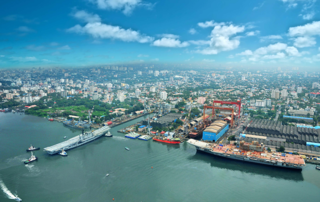
Ernakulam is the central portion of the city of Kochi in Kerala, India and has lent its name to the Ernakulam district. Many major establishments, including the Kerala High Court, the office of the Kochi Municipal Corporation and the Cochin Shipyard are situated here.
The Main Central Road, better known as MC Road is the arterial State Highway starting from Kesavadasapuram in Trivandrum city and ends at Angamaly, a suburb of Kochi city in Ernakulam District, in the state of Kerala, India. It is designated as State Highway 1 by the Kerala Public Works Department. The highway was built by Raja Kesavadas, Dewan of Travancore.

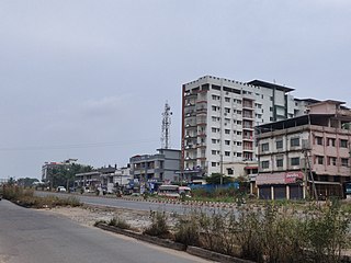
Thana is a commercial center in the city of Kannur in Kerala, South India.
U.S. Route 20 (US 20) is a part of the U.S. Highway System that runs from Newport, Oregon, to Boston, Massachusetts. In the U.S. state of New York, US 20 extends 372.32 miles (599.19 km) from the Pennsylvania state line at Ripley to the Massachusetts state line in the Berkshire Mountains. US 20 is the longest surface road in New York. It runs near the Lake Erie shore from Ripley to Buffalo and passes through the southern suburbs of Buffalo, the Finger Lakes, the glacial moraines of Central New York, and the city of Albany before crossing into Massachusetts. US 20 connects to all three major north–south Interstate Highways in Upstate New York: Interstate 390 (I-390) near Avon, I-81 south of Syracuse, and I-87 in Albany by way of Fuller Road Alternate.
U.S. Route 60 (US 60) is an east–west United States Highway within Arizona. The highway runs for 369 miles (594 km) from a junction with Interstate 10 near Quartzsite to the New Mexico State Line near Springerville. As it crosses the state, US 60 overlaps at various points: I-17, I-10, SR 77, SR 260, US 191, and US 180. Between Wickenburg and Phoenix, the route is known as Grand Avenue. From Tempe to Apache Junction, it is known as the Superstition Freeway.
Thokottu is a commercial junction to the south of Mangalore city on National Highway 66 and the gateway to Mangalore city from the South (Kerala). It is one of the major and busiest junctions of Mangalore city wherein one road goes towards east to Deralakatte and Konaje, educational hubs with several premium educational institutions and few information technology companies, the other road towards west goes to Ullal. This junction connects Mangalore city, second major city of Karnataka with Talapady and Kerala. A flyover is constructed in the junction to reduce the congestion for the travellers travelling between Mangalore city and Kerala. The creation of educational institutions in Deralakatte and Konaje has led to the construction of many commercial complexes in the area.
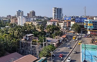
Kankanadi or Kankanady is one of the major upscale commercial and residential localities of Mangalore city. It houses many highrise buildings and transforming into a highrise hub of Mangalore CBD region along with its major counterparts like Bejai, Kadri, Attavar & Falnir. It is one of the busiest localities of Mangalore.
Kentucky Route 70 (KY 70) is a long east-east state highway that originates at a junction with U.S. Route 60 (US 60) in Smithland in Livingston County, just east of the Ohio River. The route continues through the counties of Crittenden, Caldwell, Hopkins, Muhlenberg, Butler, Edmonson, Barren, Barren, Metcalfe, Green, Taylor, Casey, Pulaski, Lincoln and back into Pulaski again to terminate at a junction with US 150 near Maretburg in Rockcastle.

The Main Eastern Highway is the lifeline of the high range townships of the Travancore region of Kerala state, India. It is also known as Punalur-Muvattupuzha Highway. Main Eastern Highway is categorized as State Highway - 08 of Kerala. It is the second longest State Highway of Kerala covering a distance of 153.6 km. The districts it passes through are Kollam, Pathanamthitta, Kottayam, Idukki and Ernakulam.
The Marikina–Infanta Highway, also known as Marcos Highway, Marilaque Road or Marikina-Infanta Road, is a scenic mountain 117.5-kilometer (73.0 mi) highway that connects Metro Manila with Infanta, Quezon in the Philippines.

Kadamattom Church is an ancient Malankara Orthodox Syrian Church, located in Kadamattom near Kolenchery, in Ernakulam district, Kerala
State Highway 2 is a State Highway in Kerala, India that starts from Thiruvananthapuram Peroorkada and ends near Thenmala Kollam by joining with Kollam-Tirumangalam NH-744. The highway is 73.2 km long. The major towns in this highway are Nedumangad,Palode and Kulathupuzha.It is a major road connecting Thiruvananthapuram the Capital City of Kerala to Tamil Nadu. In 2016 NHAI approved in principle this road as National highway.

The Indian city of Thiruvananthapuram has a well-developed transport infrastructure. The city and its suburbs may be traversed using road and rail. Within the city, city buses, taxis and auto rickshaws provide mobility. Scooters and motorcycles are the favored means of personal transport. Ola, Uber and other taxi services operate there.

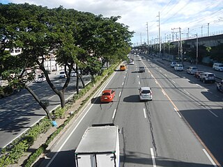
The Kochi Bypass is a segment of NH66(National Highway 66) that bypasses the CBD of the city of Kochi in Kerala, India. The highway stretches 17 km from Edapally in the Ernakulam district to Aroor in Alappuzha district, via. Palarivattom, Vyttila, Kundannoor, Madavana, Kumbalam. The Government of Kerala began the preliminary works in 1973. After a slow progress, it was partially opened for traffic in the beginning years of the 1980s. The section between Edapally and Vyttila had four lanes from the beginning. The rest of the carriageway was also upgraded to different sections of 4 lane, 5lane and 6 lanes by 2010
Coimbatore is a city in the state of Tamil Nadu, India. Most transportation in the city and suburbs is over its road network. Coimbatore is well connected to most cities and towns in India by road, rail, and air, but not through waterways. The city has successful transport infrastructure compared to other Indian cities, though road infrastructures are not well maintained and developed according to the growing needs of transport, making traffic congestion a major problem in the city. A comprehensive transport development plan has been made to address many traffic problems.
EVR Periyar Salai (EVR High Road), earlier known as Poonamallee High Road(NH 48) and originally the Grand Western Trunk Road, is an arterial road in Chennai, India. It is the longest road in Chennai. Running from east to west, the 14-kilometre (8.7 mi) road starts at Muthuswamy Bridge near Madras Medical College at Park Town and ends near Maduravoyal Junction via Kilpauk, Aminjikarai, Anna Nagar Arch, Arumbakkam, Koyambedu. It further continues west towards Poonamallee and traverses Sriperumbudur, Walajapet, and Ranipet.
National Highway 66, commonly referred to as NH 66, is a 4 lane 1,608 km (999 mi) long busy National Highway that runs roughly north–south along the western coast of India, parallel to the Western Ghats. It connects Panvel to Cape Comorin (Kanyakumari), passing through the states of Maharashtra, Goa, Karnataka, Kerala and Tamil Nadu.
Interstate business routes are roads connecting a central or commercial district of a city or town with an Interstate bypass. These roads typically follow along local streets often along a former U.S. Route or state highway that had been replaced by an Interstate. Interstate business route reassurance markers are signed as either loops or spurs using a green shield shaped sign and numbered like the shield of the parent Interstate highway.

