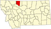
Kevin, Montana

Last updated

Kevin, Montana
Toole County Montana Incorporated and Unincorporated areas Kevin Highlighted.svg
Location of Kevin, Montana
Coordinates: 48°44′54″N111°57′58″W / 48.74833°N 111.96611°W / 48.74833; -111.96611
Country United States
State Montana
County Toole
Area
[1]
  Total0.39 sq mi (1.00 km2)
  Land0.36 sq mi (0.94 km2)
  Water0.03 sq mi (0.07 km2)
Elevation
3,330 ft (1,015 m)
Population
 (2020)
  Total154
  Density426.59/sq mi (164.51/km2)
Time zone UTC-7 (Mountain (MST))
  Summer (DST) UTC-6 (MDT)
ZIP code
59454
Area code 406
FIPS code 30-40525
GNIS feature ID0773012

Kevin is a town in Toole County, Montana, United States. The population was 154 at the 2020 census, [2] equal to the 2010 Census population. The town was named after Thomas Kevin, superintendent of the Alberta Railway & Irrigation Company. [3] Locals pronounce Kevin with a long E, like Keevin. [4]

Contents

Oil was discovered in the Kevin Sunburst Oil Field in 1922. [5]

Geography

Kevin is located at 48°44′54″N111°57′58″W / 48.74833°N 111.96611°W / 48.74833; -111.96611 (48.748338, -111.966212). [6] Interstate 15 passes near the community, with access from Exit 379. Goedertz Lake is nearby.

According to the United States Census Bureau, the town has a total area of 0.36 square miles (0.93 km2), of which 0.34 square miles (0.88 km2) is land and 0.02 square miles (0.05 km2) is water. [7]

Demographics

Historical population
CensusPop.Note
1930 324
1940 36011.1%
1960 375
1970 250−33.3%
1980 208−16.8%
1990 185−11.1%
2000 178−3.8%
2010 154−13.5%
2020 1540.0%
U.S. Decennial Census [8] [2]

2010 census

As of the census [9] of 2010, there were 154 people, 71 households, and 41 families residing in the town. The population density was 452.9 inhabitants per square mile (174.9/km2). There were 90 housing units at an average density of 264.7 per square mile (102.2/km2). The racial makeup of the town was 98.7% White, 0.6% African American, and 0.6% Native American. Hispanic or Latino of any race were 0.6% of the population.

There were 71 households, of which 25.4% had children under the age of 18 living with them, 45.1% were married couples living together, 4.2% had a female householder with no husband present, 8.5% had a male householder with no wife present, and 42.3% were non-families. 39.4% of all households were made up of individuals, and 14.1% had someone living alone who was 65 years of age or older. The average household size was 2.17 and the average family size was 2.90.

The median age in the town was 42 years. 26.6% of residents were under the age of 18; 5.1% were between the ages of 18 and 24; 20.8% were from 25 to 44; 32.4% were from 45 to 64; and 14.9% were 65 years of age or older. The gender makeup of the town was 53.2% male and 46.8% female.

2000 census

As of the census [10] of 2000, there were 178 people, 72 households, and 47 families residing in the town. The population density was 511.8 inhabitants per square mile (197.6/km2). There were 91 housing units at an average density of 261.7 per square mile (101.0/km2). The racial makeup of the town was 88.76% White, 5.62% Native American, 1.12% Asian, 0.56% Pacific Islander, 3.37% from other races, and 0.56% from two or more races. Hispanic or Latino of any race were 5.62% of the population.

There were 72 households, out of which 37.5% had children under the age of 18 living with them, 50.0% were married couples living together, 4.2% had a female householder with no husband present, and 34.7% were non-families. 29.2% of all households were made up of individuals, and 19.4% had someone living alone who was 65 years of age or older. The average household size was 2.47 and the average family size was 3.00.

In the town, the population was spread out, with 28.1% under the age of 18, 6.7% from 18 to 24, 28.7% from 25 to 44, 20.8% from 45 to 64, and 15.7% who were 65 years of age or older. The median age was 39 years. For every 100 females there were 97.8 males. For every 100 females age 18 and over, there were 106.5 males.

The median income for a household in the town was $20,417, and the median income for a family was $29,167. Males had a median income of $30,625 versus $18,750 for females. The per capita income for the town was $14,003. About 20.5% of families and 19.9% of the population were below the poverty line, including 35.7% of those under the age of eighteen and 21.2% of those 65 or over.

Related Research Articles

<span class="mw-page-title-main">Toole County, Montana</span> County in Montana, United States

Toole County is a county in the northern portion of the U.S. state of Montana. As of the 2020 census, the population was 4,971. Its county seat is Shelby. The county was established in 1914 from parts of Hill County and Teton County and was named after Joseph Toole, the first and fourth governor of Montana. Its northern boundary is the Canada–United States border south of Alberta.

<span class="mw-page-title-main">Lexington, Alabama</span> Town in Alabama, United States

Lexington is a town in Lauderdale County, Alabama, United States. It is part of the Florence–Muscle Shoals Metropolitan Statistical Area known as "The Shoals". It incorporated in 1959. As of the 2010 census, the population of the town is 735, down from 840 in 2000. The current mayor of Lexington is Sandra Killen-Burroughs.

<span class="mw-page-title-main">Mesquite Creek, Arizona</span> CDP in Mohave County, Arizona

Mesquite Creek is an unincorporated community and census-designated place (CDP) in Mohave County, Arizona, United States. The population was 403 at the 2020 census.

<span class="mw-page-title-main">Maurice, Iowa</span> City in Iowa, United States

Maurice is a city in Sioux County, Iowa, United States, along the West Branch of the Floyd River. The population was 265 at the time of the 2020 census. It is home to the "Famous Maurice Fire Escape Slide" in the town park.

<span class="mw-page-title-main">Starks, Maine</span> Town in the state of Maine, United States

Starks is a town in Somerset County, Maine, United States. The town was named after General John Stark of the Revolutionary War. The population was 593 at the 2020 census.

<span class="mw-page-title-main">Port Huron Township, Michigan</span> Charter township in Michigan, United States

Port Huron Charter Township is a charter township of St. Clair County in the U.S. state of Michigan. The population was 10,792 at the 2020 Census. The city of Port Huron is adjacent to the township.

<span class="mw-page-title-main">Comstock, Minnesota</span> City in Minnesota, United States

Comstock is a city in Clay County, Minnesota, United States. The population was 100 at the 2020 census.
<span class="mw-page-title-main">Toston, Montana</span> Census-designated place in Montana, United States

Toston is a census-designated place (CDP) in Broadwater County, Montana, United States. The population was 108 at the 2010 census.

<span class="mw-page-title-main">Cascade, Montana</span> Town in Cascade County, Montana, United States

Cascade is a town in Cascade County, Montana, United States. The population was 600 at the 2020 census. It is part of the Great Falls, Montana Metropolitan Statistical Area, which in 2020 had a population of 84,414. Cascade was incorporated in 1911.

<span class="mw-page-title-main">Simms, Montana</span> CDP in Montana, United States

Simms is a census-designated place (CDP) in Cascade County, Montana, United States. The population was 354 at the 2010 census. It is part of the Great Falls, Montana Metropolitan Statistical Area.

<span class="mw-page-title-main">Sun Prairie, Montana</span> CDP in Montana, United States

Sun Prairie is a census-designated place (CDP) in Cascade County, Montana, United States. The population was 1,630 at the 2010 census. It is part of the Great Falls Metropolitan Statistical Area and may have evolved as a remote suburb of Great Falls.

<span class="mw-page-title-main">Ulm, Montana</span> CDP in Montana, United States

Ulm is a census-designated place (CDP) in Cascade County, Montana, United States. It was originally a large ranch owned by Indiana-born cattleman William Ulm. The population was 738 at the 2010 census. It is part of the Great Falls, Montana Metropolitan Statistical Area. The Zip Code is 59485.

<span class="mw-page-title-main">Ismay, Montana</span> Town in Montana, United States

Ismay is a town in Custer County, Montana, United States. There is a post office at Ismay, and a church, and no other businesses or services. The population was 17 at the 2020 census. The town is the least-populous incorporated municipality in the state of Montana.

<span class="mw-page-title-main">Winifred, Montana</span> Town in Montana, United States

Winifred is a small town in rural north-central Fergus County, Montana, United States. It was founded in 1913 and provides services for its region's populace. The town population was 172 at the 2020 census. The current mayor is Travis Willson.

<span class="mw-page-title-main">Harrison, Montana</span> Census-designated place in Montana, United States

Harrison is a census-designated place (CDP) in Madison County, Montana, United States. The population was 137 at the 2010 census, down from 162 in 2000.

<span class="mw-page-title-main">Sunburst, Montana</span> Town in Montana, United States

Sunburst is a town in Toole County, Montana, United States. The population was 333 in the 2020 census.

<span class="mw-page-title-main">Broadview, Montana</span> Town in Montana, United States

Broadview is a town in Yellowstone County, Montana, United States. The population was 139 at the 2020 census.

Smithfield is a town in Madison County, New York, United States. Administrative offices are in the hamlet of Peterboro. The town and hamlet both are named after Peter Smith, an original land owner. As of the 2010 Census, the population was 1,288.
<span class="mw-page-title-main">Buna, Texas</span> Census-designated place in Texas, United States

Buna is an unincorporated community and census-designated place (CDP) in Jasper County, Texas, United States. The population was 2,137 at the 2020 census.

<span class="mw-page-title-main">Honey Creek, Sauk County, Wisconsin</span> Town in Wisconsin, United States

Honey Creek is a town in Sauk County, Wisconsin, United States. The town took its name from the nearby stream of the same name. The population was 749 at the 2020 census. The unincorporated communities of Denzer and Leland are located in the town.

References

  1. "ArcGIS REST Services Directory". United States Census Bureau. Retrieved September 5, 2022.
  2. 1 2 "U.S. Census website". United States Census Bureau . Retrieved November 2, 2021.
  3. "Kevin". Montana Place Names Companion. Montana Historical Society. Retrieved April 5, 2021.
  4. "Kevin - Sunburst Montana". Sunburst Montana. Sunburst Community Foundation. Retrieved January 3, 2024.
  5. "Sunburst". Montana Place Names Companion. Montana Historical Society. Retrieved April 9, 2021.
  6. "US Gazetteer files: 2010, 2000, and 1990". United States Census Bureau. February 12, 2011. Retrieved April 23, 2011.
  7. "US Gazetteer files 2010". United States Census Bureau. Archived from the original on July 2, 2012. Retrieved December 18, 2012.
  8. "Census of Population and Housing". Census.gov. Retrieved June 4, 2015.
  9. "U.S. Census website". United States Census Bureau . Retrieved December 18, 2012.
  10. "U.S. Census website". United States Census Bureau . Retrieved January 31, 2008.