Cut Bank, Montana

Last updated

Cut Bank
Cut Bank Creek Montana.jpg
Housing along Cut Bank Creek
Glacier County Montana Incorporated and Unincorporated areas Cut Bank Highlighted.svg
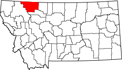
Location of Cut Bank, Montana
Coordinates: 48°38′5″N112°19′52″W / 48.63472°N 112.33111°W / 48.63472; -112.33111
Country United States
State Montana
County Glacier
Area
[1]
  Total1.16 sq mi (3.01 km2)
  Land1.16 sq mi (3.00 km2)
  Water0.00 sq mi (0.01 km2)
Elevation
3,773 ft (1,150 m)
Population
 (2020)
  Total3,056
  Density2,641.31/sq mi (1,020.07/km2)
Time zone UTC−7 (Mountain (MST))
  Summer (DST) UTC−6 (MDT)
ZIP code
59427
Area code 406
FIPS code 30-18775
GNIS feature ID0770395
Website cityofcutbank.org

Cut Bank is a city in and the county seat of Glacier County, Montana, United States, located just east of the "cut bank" (gorge) along Cut Bank Creek. [2] The population was 3,056 at the 2020 census, [3] The town began in 1891 with the arrival of the Great Northern Railway. [4]

Contents

Geography

Cut Bank is located in eastern Glacier County at 48°38′5″N112°19′52″W / 48.63472°N 112.33111°W / 48.63472; -112.33111 (48.634801, −112.331090). [5] U.S. Route 2 passes through the city as Main Street, leading east 22 miles (35 km) to Interstate 15 at Shelby and west 34 miles (55 km) to Browning. The Blackfeet Indian Reservation is located just west of Cut Bank, on the western side of Cut Bank Creek.

According to the United States Census Bureau, the city has a total area of 0.99 square miles (2.56 km2), all land. [6]

The city is located 30 miles (48 km) south of the Canada–United States border. The name of the city comes from the cut bank (gorge) a scenic hazard to navigation and a geologic feature of the same name. The Cut Bank Creek river is spanned cliffs to cliffs by a scenic elevated railway bridge high above the canyon floor less than a mile from the edge of the town.

Demographics

Historical population
CensusPop.Note
1900 43
1910 5001,062.8%
1920 1,181136.2%
1930 845−28.5%
1940 2,509196.9%
1950 3,72148.3%
1960 4,53922.0%
1970 4,004−11.8%
1980 3,688−7.9%
1990 3,329−9.7%
2000 3,105−6.7%
2010 2,869−7.6%
2020 3,0566.5%
source: [7]

U.S. Decennial Census [8] [3]

2010 census

As of the 2010 census, [9] there were 2,869 people, 1,249 households and 739 families residing in the city. The population density was 2,927 inhabitants per square mile (1,130.1/km2). There were 1,441 housing units at an average density of 1,470 per square mile (567.6/km2). The racial makeup of the city was 74.7% White, 0.2% African American, 19.0% Native American, 0.5% Asian, 0.4% from other races, and 5.2% from two or more races. Hispanic or Latino of any race were 2.5% of the population.

There were 1,249 households, of which 30.3% had children under the age of 18 living with them, 43.4% were married couples living together, 10.6% had a female householder with no husband present, 5.1% had a male householder with no wife present, and 40.8% were non-families. 35.7% of all households were made up of individuals, and 14.6% had someone living alone who was 65 years of age or older. The average household size was 2.26 and the average family size was 2.94.

The median age was 41.2 years. 24.4% of residents were under the age of 18; 7.7% were between the ages of 18 and 24; 22.4% were from 25 to 44; 28.8% were from 45 to 64; and 16.8% were 65 years of age or older. The gender makeup of the city was 48.2% male and 51.8% female.

Transportation

Cut Bank is served by Amtrak's Empire Builder long-distance train on its route from Chicago to Seattle/Portland. [10] There is one eastbound and one westbound train per day.

A train of the same name served the city under Amtrak's predecessor, the Great Northern Railway. The city, in conjunction with Amtrak and the current track owner BNSF Railway, recently repainted its historic train station in the traditional Great Northern depot colors.

The city contains an important railroad freight yard operated by the BNSF.

Cut Bank Municipal Airport is three miles southwest of Cut Bank.

Education

Cut Bank Public Schools educates students from kindergarten through 12th grade. [11] Cut Bank High School's team name is the Wolves. [12]

Cut Bank has a public library, called the Glacier County Library. [13]

Climate

Cut Bank experiences a semi-arid climate (Köppen BSk) with long, cold, dry winters and short, warm, wetter summers. In winter, bitterly cold arctic air masses move south and impact the eastern side of the American Continental Divide. During such invasions Cut Bank, with its comparatively high elevation and topography is frequently the coldest location in the lower 48 U.S. States. Being close to the eastern slopes of the Rocky Mountains also makes the area subject to occasional Chinook winds that can rapidly increase the local temperature.

Climate data for Cut Bank, Montana (Cut Bank Municipal Airport), 19912020 normals, extremes 1903present
MonthJanFebMarAprMayJunJulAugSepOctNovDecYear
Record high °F (°C)67
(19)
71
(22)
77
(25)
87
(31)
91
(33)
101
(38)
106
(41)
107
(42)
97
(36)
88
(31)
79
(26)
67
(19)
107
(42)
Mean maximum °F (°C)54.8
(12.7)
54.7
(12.6)
62.5
(16.9)
72.1
(22.3)
80.4
(26.9)
85.5
(29.7)
93.1
(33.9)
93.3
(34.1)
88.0
(31.1)
76.2
(24.6)
61.9
(16.6)
53.7
(12.1)
95.3
(35.2)
Average high °F (°C)32.3
(0.2)
34.2
(1.2)
42.6
(5.9)
52.3
(11.3)
62.3
(16.8)
70.4
(21.3)
80.2
(26.8)
79.7
(26.5)
68.7
(20.4)
54.4
(12.4)
41.0
(5.0)
32.9
(0.5)
54.2
(12.3)
Daily mean °F (°C)21.8
(−5.7)
23.1
(−4.9)
31.1
(−0.5)
40.2
(4.6)
49.6
(9.8)
57.6
(14.2)
64.9
(18.3)
63.9
(17.7)
54.4
(12.4)
42.0
(5.6)
30.6
(−0.8)
22.8
(−5.1)
41.8
(5.4)
Average low °F (°C)11.3
(−11.5)
12.0
(−11.1)
19.7
(−6.8)
28.1
(−2.2)
37.0
(2.8)
44.7
(7.1)
49.6
(9.8)
48.0
(8.9)
40.1
(4.5)
29.7
(−1.3)
20.2
(−6.6)
12.6
(−10.8)
29.4
(−1.4)
Mean minimum °F (°C)−18.9
(−28.3)
−14.0
(−25.6)
−5.6
(−20.9)
11.6
(−11.3)
23.4
(−4.8)
34.8
(1.6)
39.5
(4.2)
37.2
(2.9)
25.7
(−3.5)
9.1
(−12.7)
−6.8
(−21.6)
−15.3
(−26.3)
−28.8
(−33.8)
Record low °F (°C)−46
(−43)
−47
(−44)
−34
(−37)
−25
(−32)
9
(−13)
21
(−6)
32
(0)
25
(−4)
−4
(−20)
−14
(−26)
−33
(−36)
−46
(−43)
−47
(−44)
Average precipitation inches (mm)0.22
(5.6)
0.23
(5.8)
0.36
(9.1)
0.95
(24)
1.65
(42)
2.73
(69)
1.29
(33)
0.96
(24)
1.08
(27)
0.57
(14)
0.42
(11)
0.31
(7.9)
10.77
(274)
Average snowfall inches (cm)4.0
(10)
4.1
(10)
6.8
(17)
3.9
(9.9)
1.2
(3.0)
0.0
(0.0)
0.0
(0.0)
0.0
(0.0)
0.4
(1.0)
3.0
(7.6)
5.6
(14)
4.4
(11)
33.4
(83.5)
Average precipitation days (≥ 0.01 in)4.24.25.97.99.811.36.76.16.55.14.84.276.7
Average snowy days (≥ 0.1 in)4.94.87.03.20.90.00.00.00.52.54.55.233.5
Source: NOAA (snow, snow days 19812010) [14] [15] [16]

Notable people

See also

Related Research Articles

<span class="mw-page-title-main">Pondera County, Montana</span> County in Montana, United States

Pondera County is a county in the U.S. state of Montana. As of the 2020 census, the population was 5,898. Its county seat is Conrad.

<span class="mw-page-title-main">Glacier County, Montana</span> County in Montana, United States

Glacier County is located in the U.S. state of Montana. As of the 2020 census, the population was 13,778. The county is located in northwestern Montana between the Great Plains and the Rocky Mountains, known to the Blackfeet as the "Backbone of the World". The county is geographically and culturally diverse and includes the Blackfeet Indian Reservation, Glacier National Park, and Lewis and Clark National Forest. The county is bordered by 75 miles of international boundary with two ports of entry open year-round and one seasonal international border crossing into Alberta, Canada.

<span class="mw-page-title-main">Flathead County, Montana</span> County in Montana, United States

Flathead County is in the U.S. state of Montana. At the 2020 census, its population was 104,357, making it the state's fourth most populous county. Its county seat is Kalispell. Its numerical designation is 7. Its northern border is on the state's north border, making it contiguous with the Canada–US border, facing British Columbia.

<span class="mw-page-title-main">Custer County, Montana</span> County in Montana, United States

Custer County is a county located in the U.S. state of Montana. As of the 2020 census, the population was 11,867. Its county seat is Miles City. The county was established on June 2, 1865, as one of the nine original counties of the Territory of Montana named Big Horn County, and was renamed on February 16, 1877, in honor of Lieutenant Colonel George Armstrong Custer.

<span class="mw-page-title-main">Scobey, Montana</span> City in Montana, United States

Scobey is a city in and the county seat of Daniels County, Montana, United States. The population was 999 at the 2020 census.

<span class="mw-page-title-main">Columbia Falls, Montana</span> City in Montana, United States

Columbia Falls is a city along the Flathead River in Flathead County, Montana, United States. The population was 5,308 at the 2020 census. Columbia Falls has been ranked as one of the best and safest places to live in Montana.

<span class="mw-page-title-main">Kalispell, Montana</span> City in Montana, United States

Kalispell is a city in Montana and the county seat of Flathead County, Montana, United States. The 2020 census put Kalispell's population at 24,558. In Montana's northwest region, it is the largest city and the commercial center of the Kalispell Micropolitan Statistical Area. The name Kalispell is a Salish word meaning "flat land above the lake"..

<span class="mw-page-title-main">Martin City, Montana</span> Unincorporated community in Montana, United States

Martin City is an unincorporated community and census-designated place (CDP) in Flathead County, Montana, United States. As of the 2010 census, it had a population of 500, up from 331 in 2000.

<span class="mw-page-title-main">Whitefish, Montana</span> City in Montana, United States

Whitefish is a city in Flathead County, Montana, United States. According to the 2020 United States Census, there were 7,751 people in the city.

<span class="mw-page-title-main">Manhattan, Montana</span> Town in Montana, United States

Manhattan is a town in Gallatin County, Montana, United States. The population was 2,086 at the 2020 census. It is part of the 'Bozeman Micropolitan Statistical Area'.

<span class="mw-page-title-main">Browning, Montana</span> Former town in Montana, United States

Browning is a former town in Glacier County, Montana, United States. It is the headquarters for the Blackfeet Indian Reservation and was the only incorporated town on the Reservation. The population was 1,018 at the 2020 census.

<span class="mw-page-title-main">East Glacier Park Village, Montana</span> CDP in Montana, United States

East Glacier Park is an unincorporated community and census-designated place (CDP) in Glacier County, Montana, United States. As of the 2020 census, it had a population of 354.

<span class="mw-page-title-main">Starr School, Montana</span> Census-designated place in Montana, United States

Starr School is a census-designated place (CDP) in Glacier County, Montana, United States. The population was 252 at the 2010 census.

<span class="mw-page-title-main">Havre, Montana</span> City in Montana, United States

Havre is the county seat and largest city in Hill County, Montana, United States. Havre is nicknamed the crown jewel of the Hi-Line. It is said to be named after the city of Le Havre in France. As of the 2020 census the population was 9,362.

<span class="mw-page-title-main">Augusta, Montana</span> Census-designated place in Montana, United States

Augusta is an unincorporated community and census-designated place (CDP) in Lewis and Clark County, Montana, United States. The population was 309 at the 2010 census and rose to 316 in the 2020 census. The most accepted version in the naming of this town is after Augusta Hogan, thought to be the first child born in this town, the daughter of J. D. Hogan, an early rancher.

<span class="mw-page-title-main">Chester, Montana</span> Town in Montana, United States

Chester is a town in and the county seat of Liberty County, Montana, United States. The population was 847 at the time of both the 2010 and 2020 U.S. Census.

<span class="mw-page-title-main">Conrad, Montana</span> City in Montana, United States

Conrad is a city in and the county seat of Pondera County, Montana, United States. The population was 2,318 at the 2020 census. Each June, the Whoop Up Days, a town wide celebration that includes a parade and rodeo, takes place in Conrad.

<span class="mw-page-title-main">Valier, Montana</span> Town in Montana, United States

Valier is a town in Pondera County, Montana, United States. The population was 530 at the 2020 census.

<span class="mw-page-title-main">Shelby, Montana</span> City in Montana, United States

Shelby is a city in and the county seat of Toole County, Montana, United States. The population was 3,169 at the 2020 census.

<span class="mw-page-title-main">Joplin, Montana</span> Unincorporated community in Montana, United States

Joplin is a unincorporated community and census-designated place (CDP) in Liberty County, Montana, United States. The population was 157 at the 2010 census.

References

  1. "ArcGIS REST Services Directory". United States Census Bureau. Retrieved September 5, 2022.
  2. "Find a County". National Association of Counties. Archived from the original on May 31, 2011. Retrieved June 7, 2011.
  3. 1 2 "U.S. Census website". United States Census Bureau . Retrieved November 2, 2021.
  4. "Cut Bank". Montana Place Names Companion. Montana Historical Society. Retrieved April 2, 2021.
  5. "US Gazetteer files: 2010, 2000, and 1990". United States Census Bureau. February 12, 2011. Retrieved April 23, 2011.
  6. "US Gazetteer files 2010". United States Census Bureau. Archived from the original on January 25, 2012. Retrieved December 18, 2012.
  7. Moffatt, Riley. Population History of Western U.S. Cities & Towns, 1850-1990. Lanham: Scarecrow, 1996, 129.
  8. "Census of Population and Housing". Census.gov. Retrieved July 16, 2016.
  9. "U.S. Census website". United States Census Bureau . Retrieved December 18, 2012.
  10. "Cut Bank, Montana". Amtrak. Retrieved June 14, 2019.
  11. "Cut Bank School District 15" . Retrieved April 12, 2021.
  12. "Member Schools". Montana High School Association. Retrieved April 19, 2021.
  13. "Montana Public Libraries". PublicLibraries.com. Retrieved June 14, 2019.
  14. "NOWData - NOAA Online Weather Data". National Oceanic and Atmospheric Administration . Retrieved July 17, 2021.
  15. "Summary of Monthly Normals 19912020". National Oceanic and Atmospheric Administration . Retrieved July 17, 2021.
  16. "U.S. Climate Normals Quick Access – Station: Cut Bank Airport, MT (19812010)". National Oceanic and Atmospheric Administration. Retrieved December 31, 2022.