East Glacier Park Village, Montana

Last updated

East Glacier Park, Montana
CDP
East Glacier Park Village MT - aerial.jpg
Glacier County Montana Incorporated and Unincorporated areas East Glacier Park Village Highlighted.svg
Location of East Glacier Park, Montana
Coordinates: 48°26′49″N113°13′23″W / 48.44694°N 113.22306°W / 48.44694; -113.22306
CountryUnited States
State Montana
County Glacier
Area
[1]
  Total4.36 sq mi (11.29 km2)
  Land4.36 sq mi (11.29 km2)
  Water0.00 sq mi (0.00 km2)
Elevation
4,823 ft (1,470 m)
Population
 (2020)
  Total354
  Density81.21/sq mi (31.36/km2)
Time zone UTC−7 (Mountain (MST))
  Summer (DST) UTC−6 (MDT)
Area code 406
FIPS code 30-22985
GNIS feature ID1867336 [2]

East Glacier Park (Blackfeet: Omahkoyis, "Big Tree Lodge") is an unincorporated community and census-designated place (CDP) in Glacier County, Montana, United States. [2] As of the 2020 census, it had a population of 354. [3]

Contents

History

The Great Northern Railway platted the community of Midvale in the 1890s. [4] The town name was eventually changed to Glacier Park and officially became East Glacier Park in 1949. [4] There are two National Register of Historic Places listings: the Ranger Station Historic District and the Women's Club. [5] [6]

2022 attack

On July 19, 2022, 37-year-old Derick Amos Madden rammed his pickup truck (a Toyota Tacoma) into a Syracuse, New York, family in East Glacier Park Village. After crashing, he emerged with a shotgun and fatally shot the father and his 18-month-old daughter. He also critically injured the mother and the sister-in-law, the latter of whom had been in a relationship with Madden. Madden, who also used a knife in the attack, was subsequently killed by the sister-in-law when she fought back. Two other children in the family survived uninjured. [7] [8]

Geography

According to the United States Census Bureau, the CDP has a total area of 4.4 square miles (11 km2), all land. A significant number of lakes are located in the area.

Climate

East Glacier's climate is borderline Subarctic / Humid Continental, with warm summers, and winters generally beginning in November and lasting into March, bringing cold temperatures and over 176 inches of snowfall annually.

Climate data for East Glacier, Montana, 1991–2020 normals, 1971-2020 extremes: 4806ft (1465m)
MonthJanFebMarAprMayJunJulAugSepOctNovDecYear
Record high °F (°C)57
(14)
63
(17)
67
(19)
80
(27)
86
(30)
89
(32)
97
(36)
97
(36)
92
(33)
86
(30)
67
(19)
55
(13)
97
(36)
Mean maximum °F (°C)48.3
(9.1)
49.1
(9.5)
55.0
(12.8)
65.4
(18.6)
74.5
(23.6)
81.1
(27.3)
87.2
(30.7)
87.6
(30.9)
82.7
(28.2)
70.7
(21.5)
55.5
(13.1)
47.3
(8.5)
89.5
(31.9)
Mean daily maximum °F (°C)30.4
(−0.9)
30.5
(−0.8)
37.1
(2.8)
45.6
(7.6)
55.6
(13.1)
64.1
(17.8)
73.8
(23.2)
74.0
(23.3)
63.3
(17.4)
49.9
(9.9)
36.3
(2.4)
29.3
(−1.5)
49.2
(9.5)
Daily mean °F (°C)21.7
(−5.7)
21.8
(−5.7)
28.0
(−2.2)
36.1
(2.3)
44.9
(7.2)
52.7
(11.5)
59.9
(15.5)
59.2
(15.1)
50.5
(10.3)
39.6
(4.2)
29.0
(−1.7)
21.9
(−5.6)
38.8
(3.8)
Mean daily minimum °F (°C)13.1
(−10.5)
13.0
(−10.6)
18.9
(−7.3)
26.5
(−3.1)
34.3
(1.3)
41.3
(5.2)
46.0
(7.8)
44.4
(6.9)
37.7
(3.2)
29.4
(−1.4)
21.8
(−5.7)
14.6
(−9.7)
28.4
(−2.0)
Mean minimum °F (°C)−17.2
(−27.3)
−12.8
(−24.9)
−6.5
(−21.4)
9.0
(−12.8)
23.0
(−5.0)
31.3
(−0.4)
36.6
(2.6)
33.6
(0.9)
25.8
(−3.4)
9.8
(−12.3)
−4.6
(−20.3)
−13.4
(−25.2)
−27.9
(−33.3)
Record low °F (°C)−36
(−38)
−44
(−42)
−35
(−37)
−13
(−25)
16
(−9)
15
(−9)
30
(−1)
18
(−8)
8
(−13)
−14
(−26)
−26
(−32)
−42
(−41)
−44
(−42)
Average precipitation inches (mm)3.09
(78)
2.56
(65)
2.55
(65)
2.21
(56)
2.89
(73)
4.00
(102)
1.54
(39)
1.46
(37)
2.17
(55)
2.55
(65)
2.78
(71)
2.63
(67)
30.43
(773)
Average snowfall inches (cm)29.4
(75)
26.8
(68)
23.9
(61)
15.7
(40)
4.0
(10)
1.4
(3.6)
0.0
(0.0)
0.4
(1.0)
2.1
(5.3)
9.9
(25)
21.2
(54)
29.9
(76)
164.7
(418.9)
Average extreme snow depth inches (cm)26.1
(66)
30.4
(77)
30.7
(78)
22.7
(58)
7.2
(18)
0.8
(2.0)
0.0
(0.0)
0.3
(0.76)
1.3
(3.3)
7.8
(20)
11.2
(28)
18.5
(47)
37.4
(95)
Source 1: NOAA [9]
Source 2: XMACIS2 (records, monthly max/mins & snowfall/depth) [10]
Climate data for East Glacier, snowfall 1949-present
MonthJanFebMarAprMayJunJulAugSepOctNovDecYear
Record high °F (°C)57
(14)
63
(17)
67
(19)
80
(27)
86
(30)
89
(32)
97
(36)
97
(36)
92
(33)
86
(30)
67
(19)
53
(12)
97
(36)
Mean daily maximum °F (°C)32.6
(0.3)
34.5
(1.4)
40.8
(4.9)
48.8
(9.3)
58.2
(14.6)
66.8
(19.3)
74.9
(23.8)
74.7
(23.7)
63.7
(17.6)
53.1
(11.7)
38.0
(3.3)
31.1
(−0.5)
51.4
(10.8)
Mean daily minimum °F (°C)12.8
(−10.7)
13.6
(−10.2)
19.4
(−7.0)
27.1
(−2.7)
34.3
(1.3)
40.7
(4.8)
45.3
(7.4)
44.0
(6.7)
37.4
(3.0)
29.5
(−1.4)
21.4
(−5.9)
13.4
(−10.3)
28.2
(−2.1)
Record low °F (°C)−36
(−38)
−44
(−42)
−35
(−37)
−13
(−25)
16
(−9)
15
(−9)
30
(−1)
18
(−8)
8
(−13)
−12
(−24)
−26
(−32)
−42
(−41)
−44
(−42)
Average precipitation inches (mm)2.43
(62)
1.90
(48)
1.89
(48)
1.67
(42)
2.34
(59)
3.30
(84)
1.74
(44)
1.33
(34)
1.76
(45)
1.74
(44)
2.60
(66)
2.44
(62)
25.14
(638)
Average snowfall inches (cm)34.4
(87)
26.5
(67)
25.1
(64)
18.9
(48)
4.1
(10)
1.0
(2.5)
0.0
(0.0)
0.2
(0.51)
2.3
(5.8)
8.3
(21)
24.5
(62)
31.1
(79)
176.4
(446.81)
Average precipitation days14111310101188891113126
Average snowy days1289620.200.11381059.3
Source: "NowData Great Falls". NWS. Retrieved December 26, 2019.

Demographics

Historical population
CensusPop.Note
2020 354
U.S. Decennial Census [11]

As of the census [12] of 2000, there were 396 people, 148 households, and 101 families residing in the CDP. The population density was 90.9 inhabitants per square mile (35.1/km2). There were 219 housing units at an average density of 50.3 per square mile (19.4/km2). The racial makeup of the CDP was 43.43% White, 0.25% African American, 51.77% Native American, 1.26% from other races, and 3.28% from two or more races. Hispanic or Latino of any race were 0.76% of the population.

There were 148 households, out of which 35.1% had children under the age of 18 living with them, 50.7% were married couples living together, 14.2% had a female householder with no husband present, and 31.1% were non-families. 23.0% of all households were made up of individuals, and 4.1% had someone living alone who was 65 years of age or older. The average household size was 2.68 and the average family size was 3.27.

In the CDP, the population was spread out, with 32.1% under the age of 18, 5.6% from 18 to 24, 28.8% from 25 to 44, 26.5% from 45 to 64, and 7.1% who were 65 years of age or older. The median age was 36 years. For every 100 females, there were 93.2 males. For every 100 females age 18 and over, there were 92.1 males.

The median income for a household in the CDP was $37,417, and the median income for a family was $39,250. Males had a median income of $32,250 versus $27,917 for females. The per capita income for the CDP was $17,318. About 14.3% of families and 14.1% of the population were below the poverty line, including 17.3% of those under age 18 and 26.8% of those age 65 or over.

Infrastructure

Transportation

The East Glacier Park Amtrak Station is open seasonally during the spring, summer and fall, served by the Empire Builder between Chicago and Seattle/Portland. During the winter the stop is at Browning, Montana, just east of East Glacier Village.[ citation needed ] Glacier Park International Airport at Kalispell is the closest airport.

Emergency services

The East Glacier Volunteer Fire Department was founded in 1968. Today, it consists of around 18 volunteers who help protect the village and surrounding area from the threat of wildland fire.

See also

Related Research Articles

<span class="mw-page-title-main">Glacier County, Montana</span> County in Montana, United States

Glacier County is located in the U.S. state of Montana. As of the 2020 census, the population was 13,778. The county is located in northwestern Montana between the Great Plains and the Rocky Mountains, known to the Blackfeet as the "Backbone of the World". The county is geographically and culturally diverse and includes the Blackfeet Indian Reservation, Glacier National Park, and Lewis and Clark National Forest. The county is bordered by 75 miles of international boundary with two ports of entry open year-round and one seasonal international border crossing into Alberta, Canada.

<span class="mw-page-title-main">Hazardville, Connecticut</span> Census-designated place in Connecticut, United States

Hazardville is a section of the town of Enfield, Connecticut, in Hartford County. It is a census-designated place (CDP) that had a total population of 4,599 as of the 2010 census.

<span class="mw-page-title-main">Marshfield Hills, Massachusetts</span> Census-designated place in Massachusetts, United States

Marshfield Hills is a census-designated place (CDP) in the town of Marshfield in Plymouth County, Massachusetts, United States. The population was 2,356 at the 2010 census. The historic center of the village has been designated a historic district and listed on the National Register of Historic Places.

<span class="mw-page-title-main">Bigfork, Montana</span> Unincorporated community in Montana, United States

Bigfork is a census-designated place (CDP) in Flathead County, Montana, United States. It is within Montana's Rocky Mountains. The population was 5,118 at the 2020 census, up from 4,270 in 2010.

<span class="mw-page-title-main">Coram, Montana</span> Unincorporated community in Montana, United States

Coram is an unincorporated community and census-designated place (CDP) in Flathead County, Montana, United States. The population was 539 in 2010, up from 337 at the 2000 census. Coram lies 7 miles (11 km) southwest of the western entrance of Glacier National Park.

<span class="mw-page-title-main">Martin City, Montana</span> Unincorporated community in Montana, United States

Martin City is an unincorporated community and census-designated place (CDP) in Flathead County, Montana, United States. As of the 2010 census, it had a population of 500, up from 331 in 2000.

<span class="mw-page-title-main">South Browning, Montana</span> Census-designated place in Montana, United States

South Browning is a census-designated place (CDP) in Glacier County, Montana, United States. The population was 1,785 at the 2010 census. South Browning is a rural village on the Blackfeet Indian Reservation. It is bordered to the north by the town of Browning.

<span class="mw-page-title-main">Gardiner, Montana</span> Unincorporated community in Park County, Montana, United States

Gardiner is a census-designated place (CDP) in Park County, Montana, United States, along the 45th parallel. As of the 2020 census, the population of the community and nearby areas was 833.

<span class="mw-page-title-main">Avon, Montana</span> CDP in Montana, United States

Avon is a census-designated place (CDP) in Powell County, Montana, United States. The population was 124 at the 2000 census. The town sits along the Little Blackfoot River, and serves as a gateway to the Beaverhead-Deerlodge National Forest.

<span class="mw-page-title-main">Zia Pueblo, New Mexico</span> CDP in New Mexico, United States

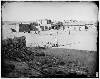
Zia Pueblo is a census-designated place (CDP) in Sandoval County, New Mexico, United States. The population was 646 at the 2000 census, with 310 males and 336 females. The pueblo after which the CDP is named is included within the CDP; it is listed on the National Register of Historic Places.

<span class="mw-page-title-main">St. James, New York</span> Hamlet and census-designated place in New York, United States

St. James is a hamlet and census-designated place (CDP) in Suffolk County, New York, United States. The population of the CDP was 13,487 at the 2020 census. St. James is part of the Town of Smithtown and is located on the North Shore of Long Island. The ZIP code is 11780.

<span class="mw-page-title-main">Croydon, Pennsylvania</span> Census-designated place in Pennsylvania, United States

Croydon is a census-designated place located in Bristol Township, Bucks County, Pennsylvania, United States. As of the 2010 census, the CDP had a total population of 9,950.

<span class="mw-page-title-main">Atlantic, Pennsylvania</span> Census-designated place in Pennsylvania, United States

Atlantic is a census-designated place (CDP) in Crawford County, Pennsylvania, United States. The population was 77 at the 2010 census, up from 43 in 2000.

<span class="mw-page-title-main">Evansburg, Pennsylvania</span> Census-designated place in Pennsylvania, United States

Evansburg is a census-designated place (CDP) in Montgomery County, Pennsylvania, United States. The population was 2,129 at the 2010 census. It is a section of Lower Providence Township and is the namesake of Evansburg State Park.

<span class="mw-page-title-main">Harrisville, Rhode Island</span> Census-designated place in Rhode Island, United States

Harrisville is a census-designated place (CDP) and village in the town of Burrillville in Providence County, Rhode Island, United States. The population was 1,605 at the 2010 census. Much of the community composes a historic district listed on the National Register of Historic Places. The village was named after nineteenth century manufacturer Andrew Harris. Previously, the village was named Rhodesville, after Captain William Rhodes, an eighteenth century privateer.

<span class="mw-page-title-main">Wilder, Vermont</span> Census-designated place in Vermont, United States

Wilder is an unincorporated village and census-designated place (CDP) within the town of Hartford in Windsor County, Vermont, United States. It is the location of the Wilder Dam on the Connecticut River. The population of the CDP was 1,690 at the 2010 census. The village center is an early example of a planned mill community, and was listed on the National Register of Historic Places as the Wilder Village Historic District in 1999.

Coeymans is a hamlet in Albany County, New York, United States. It is located on Route 144 in the southeastern part of the Town of Coeymans. The population was 835 at the 2000 census, which listed the community as a census-designated place (CDP), but it was not included as a CDP in the 2010 census.

<span class="mw-page-title-main">Brandon (CDP), Vermont</span> CDP in Vermont, United States

Brandon is an unincorporated village and census-designated place (CDP) in the town of Brandon, Rutland County, Vermont, United States. As of the 2020 census, the population was 1,727.

<span class="mw-page-title-main">Arlington (CDP), Vermont</span> Census-designated place in Vermont, United States

Arlington is a census-designated place (CDP) in the towns of Arlington and Sunderland, Bennington County, Vermont, United States. The population was 1,213 at the 2010 census.

<span class="mw-page-title-main">Canaan (village), Connecticut</span> United States historic place

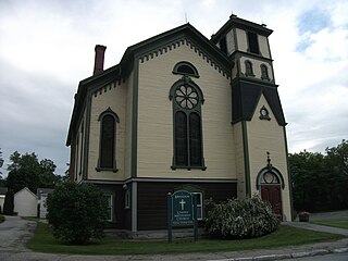
Canaan is a village and census-designated place (CDP) within the town of North Canaan in Litchfield County, Connecticut, United States. Formerly known as Canaan Depot, the village is more commonly known as Canaan Village to distinguish it from the town of Canaan located to the south of North Canaan. The Canaan Village Historic District is listed on the National Register of Historic Places. As of the 2010 census, the CDP had a population of 1,212, out of a total population of 3,315 in the town of North Canaan.

References

  1. "ArcGIS REST Services Directory". United States Census Bureau. Retrieved September 5, 2022.
  2. 1 2 U.S. Geological Survey Geographic Names Information System: East Glacier Park Village
  3. "East Glacier Park Village CDP, Montana". data.census.gov. U.S. Census Bureau. Retrieved April 11, 2023.
  4. 1 2 "East Glacier Park". Montana Place Names Companion. Montana Historical Society. Retrieved April 2, 2021.
  5. "National Register Information System  East Glacier Ranger Station Historic District (#86003696)". National Register of Historic Places . National Park Service. November 2, 2013. Retrieved April 16, 2024.
  6. Carpenter, Becky; Flick, Joann (April 1, 2013). "National Register of Historic Places Registration Form: Glacier Park Women's Club". Yumpu . National Register of Historic Places. Retrieved April 16, 2024.
  7. Brown, Matthew (July 19, 2022). "Pickup driver hits family in Montana, kills 2 with shotgun". Associated Press. Retrieved July 20, 2022.
  8. Stelloh, Tim (July 19, 2022). "Toddler and her father killed in Montana after a man drove into a family and started shooting, officials say". NBC News. Retrieved July 20, 2022.
  9. "East Glacier, Montana 1991-2020 Monthly Normals" . Retrieved August 16, 2023.
  10. "xmACIS". National Oceanic and Atmospheric Administration. Retrieved November 21, 2023.
  11. "Census of Population and Housing". Census.gov. Retrieved June 4, 2016.
  12. "U.S. Census website". United States Census Bureau . Retrieved January 31, 2008.